March 3, 2009: Ice extent nears annual maximum
Sign up for the  Arctic Sea Ice News RSS feed for automatic notification of analysis updates. Updates are also available via Twitter.
Arctic sea ice extent continued to increase through the month of February, as it approaches its annual maximum. Ice extent averaged for February 2009 is the fourth-lowest February in the satellite record. From February 18 to 22, ice extent declined slightly, primarily because of weather conditions off the coast of Alaska; ice extent then rebounded.
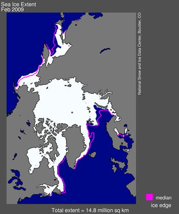
 Figure 1. Arctic sea ice extent for February 2009 was 14.84 million square kilometers (5.73 million square miles). The magenta line shows the 1979–2000 average extent for December. The black cross indicates the geographic North Pole. Sea Ice Index data. About the data. —Credit: National Snow and Ice Data Center. High-resolution image
Overview of conditions
Arctic sea ice extent averaged for the month of February was 14.84 million square kilometers (5.73 million square miles). February extent was 800,000 square kilometers (309,000 square miles) less than the 1979–2000 average, and 140,000 square kilometers (54,000 square miles) less than for February 2008.
During the month of February, Arctic sea ice extent increased by 520,000 square kilometers (201,000 square miles), an average increase of 19,000 square kilometers (7,300 square miles) per day. These values are based on data from the F13 Special Sensor Microwave/Imager (SSM/I) sensor, which NSIDC is once again using because of problems with the sensor on the F15 satellite. See our February 26 post for details.
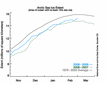
 Figure 2. The graph above shows daily sea ice extent. The solid blue line indicates 2008–2009; the dashed green line shows 2006–2007 (the record-low summer minimum occurred in 2007); and the solid gray line indicates average extent from 1979 to 2000. Sea Ice Index data. —Credit: National Snow and Ice Data Center. High-resolution image
 Conditions in context
Arctic sea ice extent continued to climb through the month of February; NSIDC scientists expect Arctic sea ice to reach its annual maximum extent sometime in March. The date of the maximum can vary by as much as 6 weeks. The average date of the maximum is March 6, based on the satellite record from 1979 to 2008.
From February 18 to 22, ice extent declined from 14.89 million square kilometers (5.75 million square miles) to 14.80 million square kilometers (5.71 million square miles), before rebounding at the end of the month. Such ups and downs are not unusual at this time of year, as ice extent nears its annual maximum.
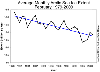
 Figure 3. Monthly February ice extent for 1979 to 2009 shows 2009 as the fourth-lowest February on record. —Credit: National Snow and Ice Data Center. High-resolution image
February 2009 compared to past Februaries
Monthly average ice extent for February 2009 was the fourth lowest in the satellite record. February 2005 had the lowest ice extent for the month; February 2006 was the second lowest; and February 2007 is in third place. Including 2009, the downward linear trend in February ice extent over the satellite record stands at –2.8% per decade.
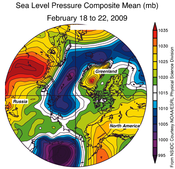
 Figure 4. The map of sea level pressure (in millibars) over the Arctic, averaged for February 18–22, 2009, shows the pressure systems that caused warm southerly winds to compact and melt the ice in the Bering Sea and Gulf of Alaska. —Credit: From National Snow and Ice Data Center courtesy NOAA/ESRL Physical Sciences Laboratory. High-resolution image
 Short-term changes in winter ice extent
The temporary decline in ice extent from February 18 to 22 illustrates the sensitivity of Arctic sea ice extent to transient weather conditions. Conditions along southern boundary of the ice cover, such as in the Bering Sea, are typically just barely cold enough for ice to exist, and the ice there can quickly expand or retreat in response to changes in temperature and winds.
The decline in mid-February appears to have been caused by the combination of low pressure centered in the western Bering Sea and high pressure centered in the western Gulf of Alaska. This weather pattern caused warm, southerly winds between the low and high pressure cells, which pushed the ice edge to the north and promoted melt. Air temperatures in the region at the 925 millibar level (approximately 915 meters [3,000 feet] above the surface) were up to 8°C (14°F) above average.
Link to NSIDC site: http://nsidc.org/arcticseaicenews/index.html


No comments:
Post a Comment