Blog Archive

Showing posts with label floods. Show all posts

Sunday, April 2, 2017

Climate Code Red: Climate change pushing floods, cyclones to new extremes, with worse to come

by David Spratt, Climate Code Red, April 1, 2017


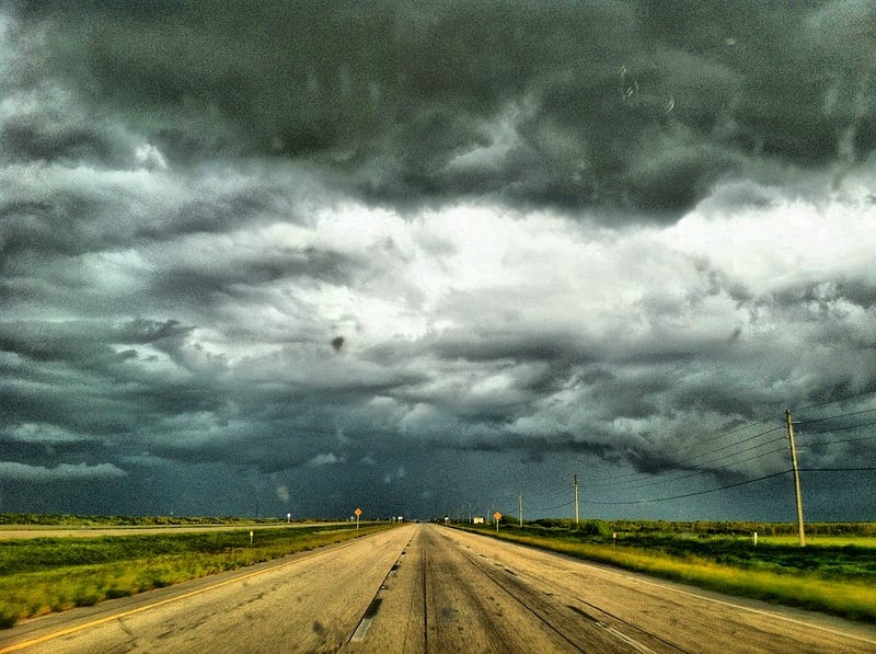
With Australia experiencing the aftermath of Cyclone Debbie and record-breaking rains and severe flooding in southeast Queensland and along the north coast of New South Wales, here’s a look at how global warming has, and will, push floods and cyclones to new extremes.

Flooding extremes

Warm air can be more humid than cold air, that is, it can hold more water vapour in absolute terms. And atmospheric water vapour content increases 7% for each 1-degree-Celsius increase in global average temperature, establishing the conditions for more intense rainfall events. 

Flash floods are likely to sweep across the Australian landscape with increasing intensity, particularly in urban or residential areas. Peak rainfall is predicted to soar with rising surface temperatures as Australia experiences ever greater extremes of heat.  

The frequency of major flood events (defined as events which caused extensive flooding within 50 kilometres of the coast, or inundation that extended 20 kilometres along the coast) along Australia's eastern seaboard has doubled in last 150 years, with climate change one of the possible factors, senior Bureau of Meteorology researchers say. 

Record-breaking heavy rainfall and a clear upward trend in downpours over the last 30 years fits in with global temperature rise caused by greenhouse gases. Statistical analysis of rainfall data from 1901 to 2010 around the globe, shows that from 1980 to 2010 there were 12% more of these intense events than would be expected in a climate without global warming. Wet regions generally saw a bigger increase in deluges and drier regions a smaller one. In southeast Asia, the observed increase in record-breaking rainfall events is as high as 56%.

Giant air streams pushing new extremes: The increase of devastating weather extremes in summer, including floods, is likely linked to human-made climate change, mounting evidence shows, with the recent discovery of giant airstreams circling the Earth, waving up and down between the Arctic and the tropics. These planetary waves transport heat and moisture. When these planetary waves stall, droughts or floods can occur. Warming caused by greenhouse-gases from fossil fuels creates favourable conditions for such events.

 “The unprecedented 2016 California drought, the 2011 U.S. heatwave and 2010 Pakistan flood, as well as the 2003 European hot spell, all belong to a most worrying series of extremes,” says Michael Mann, a lead author of the study. “The increased incidence of these events exceeds what we would expect from the direct effects of global warming alone, so there must be an additional climate change effect. In data from computer simulations as well as observations, we identify changes that favour unusually persistent, extreme meanders of the jet stream that support such extreme weather events. Human activity has been suspected of contributing to this pattern before, but now we uncover a clear fingerprint of human activity.”

Attribution studies show how the risk of a particular event may have changed due to the human influence on climate. Some attribution results surveyed by the World Meteorological Organisation include:

  • The US National Oceanic and Atmospheric Administration determined that human-caused climate change increased chances of the fatal and record rains in Louisiana by at least 40% and could have nearly doubled the odds of such a storm.
  • A scientific analysis of devastating 2014 floods in the United Kingdom, which cost an estimated $646 million in insurance losses, found that human-caused climate change has increased the chance of the extreme rain event by 43%.
  • In May–June 2016, portions of northeast France received 6 full weeks of rain in 24 hours. A formal attribution study released June 9, 2016, found that such extreme rains are at least 40%—and as much as 90%—more likely in some areas of France.
Cyclone extremes

Cyclones, in part, draw their energy from the temperature of the ocean's surface waters, so a warming climate and ocean puts more energy into storms, including cyclones, loading them with more rainfall, and stronger winds pushing more of a storm surge.
The recent Climate Council brief notes, “Increasing temperature of the surface ocean affects the intensity of cyclones, both maximum wind speeds and in the intensity of rainfall that occurs in association with the cyclone.”  The force exerted on buildings and structures when cyclones make landfall increases disproportionately with wind speed.

The Council also notes that: “Tropical cyclones form most readily when there are very warm conditions at the ocean surface and when the vertical temperature gradient through the atmosphere is strong. As this vertical gradient weakens as the climate continues to warm, it is likely that fewer tropical cyclones will form.”

Whilst the best evidence scientists have suggests cyclones are unlikely to increase in number, a 2013 study challenges the status quo, suggesting they will occur more frequently, as well becoming more intense. 

In 2013, researchers reported that the stronger hurricanes in the North Atlantic, the South Pacific, and South Indian Oceans have become more intense.  The same year, the UN meteorological agency concluded that climate change is making super typhoons worse. 

In 2015, an international research team found that a warming planet is already stoking the intensity of tropical cyclones in the northwest Pacific, and their ferocity will continue to increase even with moderate climate change over this century.

More broadly, a 2010 study found that "future projections based on theory and high-resolution dynamical models consistently indicate that greenhouse warming will cause the globally averaged intensity of tropical cyclones to shift towards stronger storms, with intensity increases of 2–11% by 2100...higher resolution modelling studies typically project substantial increases in the frequency of the most intense cyclones, and increases of the order of 20% in the precipitation rate within 100 km of the storm centre.

Recent records

With sustained wind speeds of more than 310 kilometres per hour, Typhoon Haiyan in the Philippines in November 2013 was the most powerful tropical cyclone to make landfall in recorded history. The previous record was held by Hurricane Camille, which in 1969 hit the state of Mississippi with wind speeds of just over 300 km/h. Data compiled from the US National Oceanic and Atmospheric Administration shows sea temperatures were about 0.5
1.0 degree Celsius above normal in the waters to the east of the Philippines as Haiyan began forming. The waters cooled in the storm's wake, an indication of how the storm sucked up energy.   

Hurricane Patricia which hit Mexico in October 2015 achieved a record peak intensity with maximum sustained winds 345 km/h, making it the most intense tropical cyclone on record in the Western Hemisphere, and the strongest globally in terms of 1-minute maximum sustained winds. Cyclone Winston in February 2016 was the strongest tropical cyclone to make landfall in Fiji and the South Pacific Basin in recorded history.

Attribution studies 

  • Superstorm Sandy which hit the northeast coast of the USA with devastating effect in October 2012 was made worse by unusually warm waters which increased the hurricane’s intensity. As well, human-caused sea level rise added to the storm surge, and on the stretch of the Atlantic Coast that spans from Norfolk to Boston, sea levels have been rising four times faster than the global average. Researchers say that “It is possible that subways and tunnels may not have been flooded without the warming-induced increases in sea level and storm intensity and size.”  More broadly, the authors say that “‘snowmaggedon’ in February 2010, superstorm Sandy in October 2012 , supertyphoon Haiyan in November 2013, and the Boulder floods of September 2013 were all influenced by high sea-surface temperatures that had a discernible human component.
  • The Climate Council reported that climate change exacerbated the damage caused by Cyclone Pam, which left a trail of destruction across Vanuatu in 2015.
Damage 

Reinsurance giant, MunichRe, says that "nowhere in the world are weather risks changing faster than in Eastern Asia," and concludes that "as a result of climate change... the intensity of typhoons will increase" in Eastern Asia.  On 11 November 2013, in the aftermath of super-typhoon Haiyan, MunichRe surveyed losses:

Eastern Asia has been hard hit by weather-related loss events in the past three decades. Their number has increased by more than a factor of four, causing overall losses from weather-related events of some US$ 700bn during this period. The insured losses of US$ 76bn amounted to only around 10% of overall losses, with 62% of these attributable to Japan. Floods caused 56% of the overall losses in Eastern Asia, but only 30% of insured losses. The number of floods has increased strongly and is expected to increase further in the coming decades. With insured losses of US$ 16bn, the 2011 Thailand floods caused the biggest-ever weather-related insured loss in the region. After floods, it is typhoons that cause the greatest weather-related losses. New analyses indicate a clear cycle of activity for typhoons, and increased typhoon activity is expected over the coming years..."
And in Australia, The Age reports that new modelling has shown that a cyclone the size of Debbie could have catastrophic consequences on the Gold Coast and as far as Brisbane, with winds of 260km/h, in areas where many homes and towers do not meet cyclonic safety standards. As climate change pushes cyclones further south, tens of billions of dollars worth of infrastructure is at risk. Actuaries, who predict and model scenarios for banks and insurers, have warned properties could become "uninsurable" as premiums rise up to 250% to meet this global warming challenge.

http://www.climatecodered.org/2017/04/climate-change-pushing-floods-cyclones.html

Saturday, August 13, 2016

Eric Holthaus: America’s Latest 500-Year Rainstorm Is Underway Right Now in Louisiana

Observers are calling the record floods a “classic signal of climate change” — and high-resolution models predict another one to two feet of rain by Saturday evening.

Photo: Ines Hegedus-Garcia/Flickr.

by Eric Holthaus, Pacific Standard Magazine, August 12, 2016

By mid-morning on Friday, more than a foot of rain had fallen near Kentwood, Louisiana, in just a 12-hour stretch — a downpour with an estimated likelihood of just once every 500 years, and roughly three months’ worth of rainfall during a typical hurricane season. It’s the latest in a string of exceptionally rare rainstorms that are stretching the definition of “extreme” weather. It’s exactly the sort of rainstorm that’s occurring more frequently as the planet warms.
In response to the ongoing heavy rains, Louisiana Governor John Bel Edwards declared a statewide state of emergency on Friday, and local governments are distributing sandbags, conducting water rescues, and facilitating evacuations. The New Orleans Times-Picayune is maintaining a live blog of the latest developments. The Tickfaw River north of New Orleans soared 18 feet in about 12 hours to a new record crest on Friday morning, beating the water level of April 1983, and 5 feet higher than the high-water mark during Hurricane Isaac in 2012, the last hurricane to make landfall in Louisiana.
Meanwhile, a lot more rain is still on the way. High-resolution weather models predict an additional one or two feet of rain by Saturday evening, a total the local National Weather Service referred to as “scarily high.” The NWS has issued its highest alert for excessive rain and warned of “significant to catastrophic flash flooding.” A “flash flood emergency” is in effect for the hardest-hit regions, a warning reserved only for the direst and most life-threatening events.
An instant analysis from Climate Nexus refers to today’s Louisiana rainstorm as a “classic signal of climate change.” It’s right.
Obviously, this is no ordinary storm. Though the overall structure of this meteorological event does not meet the technical requirements for a tropical storm or hurricane (it’s attached to a stalled weather front, for example), the NWS is treating it roughly the same way, and the physics of the rain clouds themselves are similar. (Tropical rain clouds are generally more efficient at converting cloud moisture into raindrops.)
This storm’s tropical nature, in combination with record-warm water temperatures just offshore in the Gulf of Mexico, are creating a nearly perfect environment for extremely heavy rain and record flooding in one of the wettest places in the country. As the atmosphere warms thanks to greenhouse gas emissions, it can hold more water vapor — and this effect makes it exponentially more likely that extreme rainfall events will occur. The weather balloon released on Friday morning from the New Orleans office of the NWS measured near all-time record levels of atmospheric moisture, higher than some measurements taken during past hurricanes. The NWS meteorologist who reported this morning’s reading remarked simply, “obviously we are in record territory.”
An instant analysis from Climate Nexus refers to today’s Louisiana rainstorm as a “classic signal of climate change.” It’s right. The NWS maintains a statistical database used to calculate the “annual exceedance probability” of a given rainfall event — basically, the expected frequency this event would occur in any given year.
Today’s rainstorm in Louisiana is at least the eighth 500-year rainfall event across America in little more than a year, including similarly extreme downpours in Oklahoma last May, central Texas (twice: last May and last October), South Carolina last October, northern Louisiana this March, West Virginia in June, and Maryland last month.
And these were just the events that the agency decided to write a report on. One notable exception to this list is the Tax Day Flood in the Houston metropolitan area this April, at least the fourth major flood in that region in a span of a year. The local flood control district extrapolated the 23.5 inches of rain over 14.5 hours in Pattison, Texas, during the Tax Day Storm to be a one-in-10,000-year event.
Statistical calculations like these make a major assumption: That the climate of the past is the same as the climate of today. That’s no longer a very good assumption.

https://psmag.com/americas-latest-500-year-rainstorm-is-underway-right-now-in-louisiana-98acbdf435d0#.uum50kkps

Friday, November 6, 2015

Global warming's fingerprints are all over recent extreme weather, research shows


Extreme-weather-repoert051


IMAGE: DANIEL KALISZ/GETTY IMAGES

by Andrew Freedman, Mashable, November 5, 2015

Extreme weather events, from droughts to floods and heat waves, are some of the most tangible present day impacts of global warming, and they will take center stage in speeches at the upcoming Paris Climate Summit. Now a new report gives leaders pushing to reduce emissions of global warming pollution, including President Obama, additional ammunition.
The report, published Thursday as a special supplement to the Bulletin of the American Meteorological Society, amounts to the largest-ever assessment of global warming’s role in intensifying the severity and altering the likelihood of extreme weather events during 2014.
It amounts to the equivalent of a climate change CSI report, and its conclusions are damning in pointing to global warming as being an accomplice to numerous damaging extreme events worldwide.
In total, the report contains analyses from 32 different research groups examining 28 extreme weather and climate events on all continents. The dozens of researchers from 21 countries found that climate change’s fingerprints are all over the scene of the crime in more than half of these events, including California wildfires, Middle Eastern drought and heat waves in Australia.
Specifically, tropical cyclones in the central Pacific, deadly heat waves in Australia, Asia and South America, and a deadly snowstorm in the Himalayas, were each in part the result of human activities, the studies show.
“For each of the past four years, this report has demonstrated that individual events, like temperature extremes, have often been shown to be linked to additional atmospheric greenhouse gases caused by human activities, while other extremes, such as those that are precipitation related, are less likely to be convincingly linked to human activities,” said Tom Karl, director of the National Centers for Environmental Information in Asheville, North Carolina.
“As the science of event attribution continues to advance, so too will our ability to detect and distinguish the effects of long-term climate change and natural variability on individual extreme events. Until this is fully realized, communities would be well-served to look beyond the range of past extreme events to guide future resiliency efforts."
These studies are part of a new and increasingly sophisticated subfield within climate science known as extreme event attribution, which involves attempts to tease out the influence of climate change, natural variability and other factors that go into extreme events.
Notably, each of the assessments of extreme climate events in Australia found clear evidence of human influences, including increased likelihood of a heat wave in Brisbane, Australia, heat waves in Adelaide and Melbourne in January 2014, record warm spring temperatures across Australia.

Man-made extremes

The events that had a man-made component to them included tropical cyclones that hit Hawaii, the Argentinean heat wave of 2013, and Australian heat waves.
Four separate studies by different scientific teams found that human influences, mainly in the form of increased emissions of global warming pollutants, caused a substantial increase in the likelihood and severity of several heat waves that struck Australia in 2014. These included events in Melbourne and in Brisbane, where extreme heat hit during the G20 Summit and global warming was conspicuously absent from leaders’ agenda.
For example, climate model simulations for 2014 indicated that man-made global warming “very likely increased the likelihood of hot and very hot November days in Brisbane by at least 25% and 44% respectively,” the G20 heat wave study concluded.
Another study published Thursday found that the record warm Australian spring of 2014, during which all-time temperature records were exceeded across the continent, “would likely not have occurred without increases in carbon dioxide over the last 50 years,” combined with weather patterns in the upper atmosphere.
Perhaps the most fascinating, albeit extremely deadly, event scientists analyzed was the blizzard that killed 43 people, including 21 trekkers, in the Himalayas. This storm resulted from the combination of Category 4 Tropical Cyclone Hudhud with other weather systems in a rare confluence of extreme events.
The study found that climate change increases the odds of such “unusual mergers” between tropical cyclones and upper level weather disturbances, because of the ways it is changing weather patterns in that region. The study detected a northward shift in intense tropical cyclones in the Bay of Bengal, as well as an intensification in the strongest storms that have occurred as water temperatures in the area have increased.
These changes have raised the risk of such storms in northeastern India and increased the frequency of extremely high amounts of moisture slamming up against the wall of the Himalayan Mountains in Nepal, where such water vapor falls as heavy snow.
“The implication of these results is that, although weather systems similar to that of 13–14 October 2014 did occur in the past, there is a tendency for both types of weather systems to interact more frequently,” the study said.
The Nepal disaster, which was the deadliest event in the history of Nepal’s mountain climbing history, had some similarities to Hurricane Sandy, when a massive tropical cyclone in the Western Atlantic interacted with a feature in the jet stream to bring several feet of snow to West Virginia while flooding parts of the East Coast with a deadly storm surge.
In addition, another study using computer modeling found that man-made global warming has increased the odds of unusually high sea surface temperatures in the western tropical Pacific Ocean and northeast Pacific Ocean. Such temperature extremes contributed to record heat in Alaska and whole scale shifts in the distribution of sea life, as well as changes in tropical cyclone behavior in the western tropical Pacific.

Many studies turned up little evidence of a man-made influence

Many studies did not turn up a man-made influence on particular extreme events, although every weather event today takes place in an atmosphere altered by man-made activities.
One study by scientists at Spain’s Barcelona Supercomputing Center, found that the all-time maximum in Antarctic sea ice in 2014 was mainly the result of unusual wind patterns that enhanced offshore production of sea ice. The study found that these winds, and the resulting spike in sea ice extent, are now less likely to occur due to climate change.
All-time maximum of Antarctic sea ice in 2014 resulted chiefly from anomalous winds that transported cold air masses away from the Antarctic continent, enhancing thermodynamic sea ice production far offshore. This type of event is becoming less likely because of climate change.
The authors of the overall report noted that attribution assessments are limited by the often limited observational records and limitations of computer models. “In general, when attribution assessments fail to find anthropogenic [man-made] signals this alone does not prove anthropogenic climate change did not influence the event,” the report states. “The failure to find a human fingerprint could be due to insufficient data or poor models and not the absence of anthropogenic effects.”

Looking back a year later: what’s the relevance to society?

The examination of 2014’s extremes demonstrates a major weakness of these studies so far, which is that they frequently take so long to be completed that they come months or a year or more after the events themselves. This is well after such events have disappeared from the news, and after many of the governmental leaders who dealt with these events — such as former Australian Prime Minister Tony Abbott — have left office.
Such studies often require supercomputing resources obtained either through national supercomputing centers — such as at Barcelona or the National Center for Atmospheric Research in Colorado — or distributed computing, in which everyday citizens use their home computers’ down time to perform computations for climate scientists. This project, known as Weather At Home, is led by a team in the U.K. and partially funded by The Guardian newspaper and Microsoft.
“Understanding our influence on specific extreme weather events is groundbreaking science that will help us adapt to climate change,” said Stephanie Herring, lead editor for the report.
“As the field of climate attribution science grows, resource managers, the insurance industry, and many others can use the information more effectively for improved decision making and to help communities better prepare for future extreme events.”
There are ongoing efforts to change this, however, and make more rapid assessments.
http://mashable.com/2015/11/05/extreme-weather-global-warming/

Sunday, October 12, 2014

Michael Mann: If a Tree Falls in the Forest, But No Scientist Says So...

by Dr. Michael E. Mann, Huffington Post, October 3, 2014

CALIFORNIA DROUGHT
Photo by George Rose, Getty Images.

Recently, the highly respected Bulletin of the American Meteorology Society ("BAMS" to those in the know), published a special issue consisting of a couple dozen articles investigating the potential impact climate change might have had on various extreme weather events of 2013. This has become somewhat of an annual rite now (see for example the corresponding 2012 special issue), a sort of scientific postmortem on what role climate change might have played in specific weather events.
It might be tempting to view this volume as an authoritative statement by the scientific community on the role climate change may or may not have had in some high profile, devastating recent extreme weather events. But that would be misguided. The BAMS special issue is not a representative, community-wide scientific assessment like those published by the National Academy of Sciences or the Intergovernmental Panel on Climate Change. The editors, instead, have solicited contributions from a relatively small number of groups, so the findings do not necessarily reflect the range of views of the broader scientific community. Some leading climate scientists who were not included in the effort have presented evidence of a greater role for climate change in several of the events dismissed or downplayed by the BAMS articles (see, e.g., Kevin Trenberth of NCAR on the September 2013 Colorado floods, Stefan Rahmstorf of the University of Potsdam on the June 2013 Central European floods, and Jennifer Francis of Rutgers on the 2013/2014 California Drought).
The California drought is of particular interest since it is both an unprecedented and absolutely devastating ongoing event. The thread potentially connecting that event to climate change is the unusual atmospheric pattern that prevailed during winter 2013/2014. That pattern was associated with a persistent "ridge" of high pressure over the western U.S. (see my previous Huffington Post piece) that caused the jet stream to plunge southward over the central U.S., chilling the eastern third of the country, and to veer northward over the west coast, pushing the warm moist subtropical Pacific air masses that would normally deliver plentiful rainfall (and snowpack) to California well to the north, resulting in bone-dry conditions in California and balmy weather in Alaska.
In fact, there are at least three different mechanisms that are potentially relevant to the connection between the 2013/2014 California drought and human-caused climate change. There is (1) the impact of climate change on the pattern of sea surface temperature (SST) off the west coast. One recent study suggests that climate change favors an SST pattern in the North Pacific that increases the incidence of the atmospheric circulation pattern responsible for the current drought. Then there is (2) the marked decrease in Arctic Sea Ice due to global warming. Studies going back more than a decade show that reduced Arctic sea ice may also favor such an atmospheric circulation pattern. More recent work by Jennifer Francis of Rutgers provides independent support for that mechanism. Finally, there is (3) the effect of global warming on soil moisture. All other things being equal, warming of soils leads to greater rates of evaporation and drying. This mechanism leads to worsened drought even if rainfall patterns are unchanged.
One of the three BAMS articles investigating the climate change connection with the California Drought (by Noah Diffenbaugh of Stanford and collaborators) did find a climate change role. They found that the high pressure ridge responsible for deflecting storms to the north was indeed made more likely by climate change. Even without accounting for increased evaporation due to warmer soils, they conclude that climate change likely increased the probability of the 2013/2014 California drought.
Two of the three BAMS articles, however, argue against a climate change connection. But here's the problem: the experimental design used in these studies completely leaves out all three of the mechanisms described above. These studies only looked at the impact of the overall warming of SSTs, without addressing whether climate change might be favoring the specific pattern of SST tied to the high pressure ridge and consequent drought. Neither of the studies accounts for the possible impact of decreasing Arctic Sea Ice (Indeed, one of the two studies explicitly acknowledges this shortcoming: "Other factors, such as the impact of climate change on the...SST gradient and storm tracks... and changes in sea ice extent... are not examined."). Finally, neither of the studies account for the impact of warming on soil evaporation. So, the fact that two of the three studies find no climate change connection may simply point to deficiencies in the approaches used. The adage "absence of evidence is not evidence of absence" would appear to apply in spades here.
Predictably, the conflicting findings and mixed message of the BAMS report led to confused and misleading headlines like the LA Times "California drought and climate warming: Studies find no clear link." Contrast that with Stanford's press release "Causes of California drought linked to climate change, Stanford scientists say" and the Sacramento Bee commentary "Droughts likely to be new normal for California."
I fear that the problem here runs far deeper than the specific flaws in the experimental designs of certain studies. What is most problematic is an over-dependence on climate model "detection and attribution" approaches for assessing the impact of climate change on the likelihood of extreme weather events. That machinery fails when the approaches used in these studies fail to capture real-world processes that may be critical to these relationships. The failure to identify a climate change impact may simply represent a failure on the part of the chosen model to capture real world processes, rather than the absence of a climate change influence on the events in question.
I'm troubled that this latter possibility receives such short thrift in many of the articles in the BAMS volume. Indeed, a quote by UK scientist Myles Allen in the New York Times' coverage of the BAMS findings encapsulates the hubris by some climate researchers: "If we don't have evidence, I don't think we should hint darkly all the time that human influence must be to blame somehow." Never mind the caricature of his fellow scientists here as furtively attempting, in the absence of any evidence, to blame every weather event on climate change (who are these scientists that Allen speaks of? I've never read any quotes by climate scientists that could possibly be characterized this way). The real problem is the lack of humility among some scientists when it comes to evaluating the potential impacts that climate change may be having on our environment. As leading climate scientist Kevin Trenberth has put it, "The environment in which all storms form has changed owing to human activities." Trenberth notes that global warming has already increased the average amount of water vapor in the atmosphere by about 4%, "extra moisture flowing into the storms that produced the heavy rains and likely contributed to the strength of the storms through added energy."
In other words, climate change has fundamentally altered the atmospheric environment in which all weather takes place, and has very likely increased the frequency and intensity of various types of extreme weather, including more intense flooding events, more extensive continental drought, more extreme heat and more intense storms. Just because an event hasn't been positively "attributed" to climate change in a formal "detection and attribution" study does not preclude speaking about the role climate change may have played, when the event is (a) consistent with expectations in a warming world, and (b) part of a larger trend. A negative finding in an attribution study could be a consequence of deficiencies in the experimental design. And the notion that scientists could possibly publish a peer-reviewed article for every weather event that may have been influenced by climate change is, on its face, absurd.
And so to return to where we started, just as a tree that falls in the forest did so whether or not a scientist was there to observe it, an extreme weather event influenced by climate change was thusly influenced, whether or not a scientist published a peer-reviewed article establishing so. We should keep that in mind when we talk about the ways that climate change is already impacting extreme weather, and likely to impact it further if we do nothing to reduce the ongoing warming of the planet.
http://www.huffingtonpost.com/michael-e-mann/climate-change-weather-bams_b_5907892.html

Monday, June 23, 2014

Jeff Masters: May 2014 Earth's warmest May since records began in 1880

by Jeff Masters, wunderblog, June 23, 2014

May 2014 was Earth's warmest May since records began in 1880, beating the record set in 2010, said NOAA's National Climatic Data Center (NCDC) and NASA. The planet has now had two back-to-back warmest months on record, since NOAA also rated April 2014 as being tied for the warmest April on record. This is the first time Earth has experienced back-to-back warmest months on record since a four-month stretch during March, April, May and June 2010. Global ocean temperatures during May 2014 were 0.59 °C (1.06 °F) above the 20th century average; this ties with June 1998, October 2003 and July 2009 for the greatest departure from average of any month in recorded history. Global land temperatures were the 4th warmest on record in May 2014, and the year-to-date January-May period has been the 5th warmest on record for the globe. Global satellite-measured temperatures in May 2014 for the lowest 8 km of the atmosphere were 6th or 3rd warmest in the 36-year record, according to Remote Sensing Systems and the University of Alabama Huntsville (UAH), respectively. Northern Hemisphere snow cover during May was the 6th lowest in the 48-year record. 

Figure 1. Departure of temperature from average for May 2014, the warmest May for the globe since record keeping began in 1880. In Europe, Latvia and Norway had their warmest May on record, as did South Korea in Asia. Portions of Central Asia and Australia were also record warm. No record cold was observed. Image credit: National Climatic Data Center (NCDC) .

Notable weather events of May 2014
According to wunderground's weather historian, Christopher C. Burt, in his May 2014 Global Weather Extremes Summary, an amazing heat wave occurred in China, Japan, and the Koreas the last week of May. Beijing saw its warmest May temperature on record with a 41.1 °C (106.0 °F) reading on May 30th, and all-time national heat records for the month of May were set for South Korea and China. A remarkable heat wave along the Baltic Sea broke the all time May heat record for Estonia (33.1 °C/91.6 °F at Kunda on May 19th) and at St. Petersburg, Russia, with 33.0 °C (91.4 °F), also on May 19th. Gambia tied its all-time national heat record (for any month) on May 4th when the temperature rose to 45.5 °C (113.9 °F) at Kaur. 


Figure 2. The deadliest weather disaster of 2014 so far has been the tragic landslide in the Argo District of Badakhshan Province, NE Afghanistan, on May 2. Death toll estimates vary widely, from 350 to 2,700. According to Dave's Landslide Blog, the landslide came after prolonged heavy rainfall in the region and occurred in the middle of the day on a Friday, when many people are likely to be at home. The slide occurred in two phases, with an initial slide that buried many people. In the aftermath, many people from local villages went to help, only to be buried by the second landslide. Image credit: BBC correspondent Bilal Sarwary.


Three billion-dollar weather disasters in May 2014
Three billion-dollar weather-related disasters hit the Earth during May 2014, according to the May 2014 Catastrophe Report from insurance broker Aon Benfield. The total number of billion-dollar weather disasters through May is 10, which is behind the record-setting pace of 2013, which had 13 such disasters by the end of May, and ended up with a record 41 such disasters by the end of the year.


Disaster 1. Torrential rains on May 14-15 in Serbia and Bosnia-Herzegovina caused extreme flooding that killed at least 80 people and caused $4.5 billion in damage. The heavy rains were caused by Extratropical Storm Yvette, a strong and slow-moving upper-level low pressure that cut off from the jet stream and lingered over the region for two days, pulling up copious amounts of moisture from the Mediterranean Sea. This aerial view of the flooded area near the Bosnian town of Brcko along the river Sava was taken May 18, 2014. (AP Photo/Bosnia Army)


Disaster 2. Flooding rains in China May 24-28 killed 37 people and caused $1.2 billion in damage. In this image we see dark clouds gathering in Guangzhou, Guangdong Province of China on May 22, 2014. Image credit: ChinaFotoPress/ChinaFotoPress via Getty Images.


Disaster 3. An outbreak of severe weather hit the Midwest, Rockies, and Northeast U.S. from May 18 to 23, causing $2.5 billion in damage. In this image taken by wunderphotographer Darhawk, we see a supercell thunderstorm near Denver, Colorado, on May 22, 2014, that prompted issuance of a tornado warning.

An El Niño Watch continues 
May 2014 featured neutral El Niño conditions in the equatorial Eastern Pacific, and sea surface temperatures have been hovering near the threshold for El Niño, +0.5 °C from average, from late April through June 23. However, the atmosphere has not been behaving like it should during an El Niño event. The Southern Oscillation Index (SOI) --the difference in surface pressure between Darwin, Australia and the island of Tahiti --tends to drop to negative values during the presence of an El Niño atmosphere, but has been positive over the past 30 days. Heavy thunderstorm activity over Indonesia and near the International Date Line is typically enhanced during an El Niño event, and was near normal at the beginning of June. This activity has picked up over the past week, but must increase substantially before we can say the atmosphere is responding in an El Niño-like fashion. The Madden-Julian Oscillation, a pattern of increased thunderstorm activity near the Equator that moves around the globe in 30-60 days, is currently weak and disorganized, and will not be a factor in moving conditions towards El Niño this week. 


NOAA is continuing its El Niño Watch, giving a 70% chance that an El Niño event will occur by the summer, with an 80% chance by the fall. In a June 20 article at Climate Central, Stephen Baxter, a seasonal forecaster with NOAA's Climate Prediction Center, said: “we’re nicely on track for a weak to moderate, but still potentially impactful” El Niño event in the fall to winter months.

Arctic sea ice falls to 3rd lowest May extent on record 
Arctic sea ice extent during May was the 3rd lowest in the 36-year satellite record, according to the National Snow and Ice Data Center (NSIDC). 

Most impressive weather videos of May 2014 

Video 1. One of the most spectacular weather videos taken in May 2014 was of a Low-Precipitation (LP) supercell thunderstorm on May 18, 2014, between Wright and Newcastle, WY. The best footage begins about 0:50 into the clip. The rotation of the thunderstorm is beautifully captured. LP supercells usually form in dry regions, where there might be just enough moisture to form the storm, but not enough moisture to rain very hard. You can usually find the updraft on the rear flank (back) of the storm. On radar, an LP will not show up as a hook echo because there's not enough precipitation within the storm to provide the reflectivity. These storms might not look that strong, but they can pack a punch. LP supercells often produce tornadoes and large hail.


Video 2. An EF-2 tornado with 120 mph winds hit this camp for oil workers just south of Watford City, North Dakota, on May 27, 2014. The tornado injured 9 people and damaged or destroyed 15 trailers. Dan Yorgason, who lives in a neighboring workers camp to the one destroyed, filmed the tornado from inside his truck. "The tornado was coming down the hill along our only escape route. There was nowhere for us to go. It was crazy," he said. The contrast of the brown of the lower part of the funnel with the white portion of the upper funnel is particularly striking 2:00 into the video.


Video 3. A severed bridge floats down the Bosna River in Bosnia and Herzegovina on May 14, 2014. Here is a video of the bridge before it was swept away.

Win $100 in this month's wunderground "Climate Lottery" 
Every three months, the Weather Channel's Guy Walton runs a "Climate Lottery" in his wunderground blog where players guess U.S. temperatures for the coming three months. Last season's winner earned a free 10-year wunderground membership. This winner of the new contest will pocket a cool $100. Simply go to Guy's blog and pick three numbers between 1 and 120 (with 1 representing the coldest possible ranking and 120 being the highest possible ranking) for June, July, and August 2014 U.S. temperatures, plus a tie-breaker “Power Ball” or overall ranking number for summer 2014. Post your prediction in the comments section of the blog. Picks must be made by midnight EDT July 5th. The National Climatic Data Center’s ranking numbers for summer 2014 will be posted on or shortly after September 15th, 2014.

I'll have a new post on Wednesday, as the tropics are quiet in the Atlantic, and no development is expected this week.


http://www.wunderground.com/blog/JeffMasters/comment.html?entrynum=2705