Blog Archive

Showing posts with label Filchner-Ronne Ice Shelf. Show all posts

Saturday, December 6, 2014

Robert Schribbler: Warm Water Rising From the Depths: Much of Antarctica Now Under Threat of Melt

by Robert Schribbler, Robert Schribbler's blog, December 5, 2014

Antarctica. A seemingly impregnable fortress of cold. Ice mountains rising 2,100 meters high. Circumpolar winds raging out from this mass of chill frost walling the warm air out. And a curtain of sea ice insulating the surface air and mainland ice sheets from an increasingly warm world. A world that is now on track to experience one of its hottest years on record.
Antarctica, the coldest place on Earth, may well seem impregnable to this warming. But like any other fortress, it has its vulnerable spots. In this case, a weak underbelly. For in study after study, we keep finding evidence that warm waters are rising up from the abyss surrounding the chill and frozen continent. And the impact and risk to Antarctica’s glacial ice mountains is significant and growing.
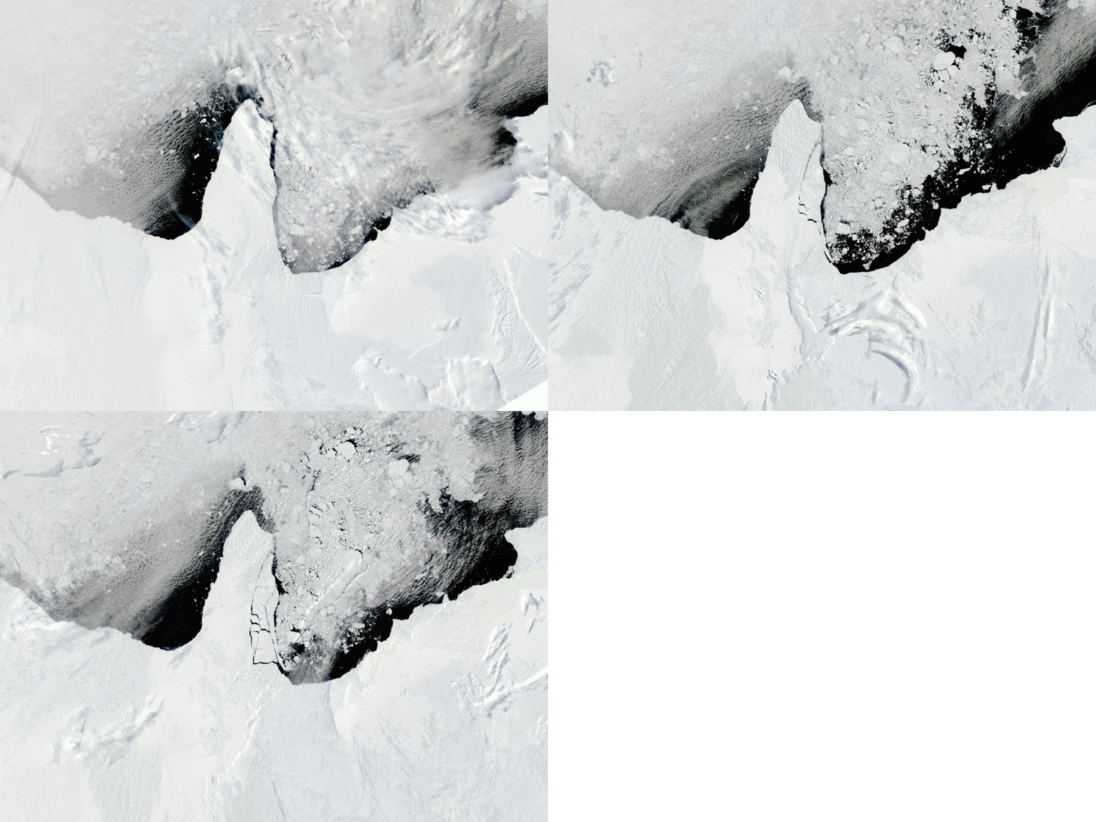
Rapid Break-up of Ice From Filchner Ronne Ice Shelf in Jan 2010
(Collapse of ice structure at the leading edge of the Filchner-Ronne Ice Shelf adjacent to a rapidly warming Weddell Sea during January of 2010. A new study has found warm water upwelling from the Circumpolar Deep Water is rapidly approaching this massive ice shelf. Loss of Filchner-Ronne and its inland buttressed glaciers would result in 10 feet of sea level rise. Image source: Commons.)
For a study this week confirmed that Antarctica is now seeing a yearly loss of ice equal to one half the volume of Mt Everest every single year. A rate of loss triple that seen just ten years ago. An acceleration that, should it continue, means a much more immediate threat to coastal regions from sea level rise than current IPCC projections now estimate.
Shoaling of the Circumpolar Deep Water
The source of this warm water comes from a deep-running current that encircles all of Antarctica. Called the Circumpolar Deep Water, this current runs along the outside margin of the continental shelf. Lately, the current has been both warming and rising up the boundaries of the continental zone. And this combined action is rapidly bringing Antarctica’s great ice sheets under increasing threat of more rapid melt.
According to a new study led by Sunke Schmidtko, this deep water current has been warming at a rate of 0.1 degrees Celsius per decade since 1975. Even before this period of more rapid deep water warming, the current was already warmer than the continental shelf waters near Antarctica’s great glaciers. With the added warming, the Circumpolar Deep Water boasts temperatures in the range of 33 to 35 degrees Fahrenheit — enough heat to melt any glacier it contacts quite rapidly.
Out in the deep ocean waters beyond the continental shelf zone surrounding Antarctica, the now warmer waters of this current can do little to effect the great ice sheets. Here Sunke’s study identifies the crux of the problem — the waters of the Circumpolar Deep Water are surging up over the continental shelf margins to contact Antarctica’s sea fronting glaciers and ice shelves with increasing frequency.
In some cases, these warm waters have risen by more than 300 feet up the continental shelf margins and come into direct contact with Antarctic ice — causing it to rapidly melt. This process is most visible in the Amundsen Sea where an entire flank of West Antarctica is now found to be undergoing irreversible collapse. The great Pine Island Glacier, the Thwaites Glacier and many of its tributaries altogether composing enough ice to raise sea levels by 4 feet are now at the start of their last days. All due to an encroachment of warm water rising up from the abyss.
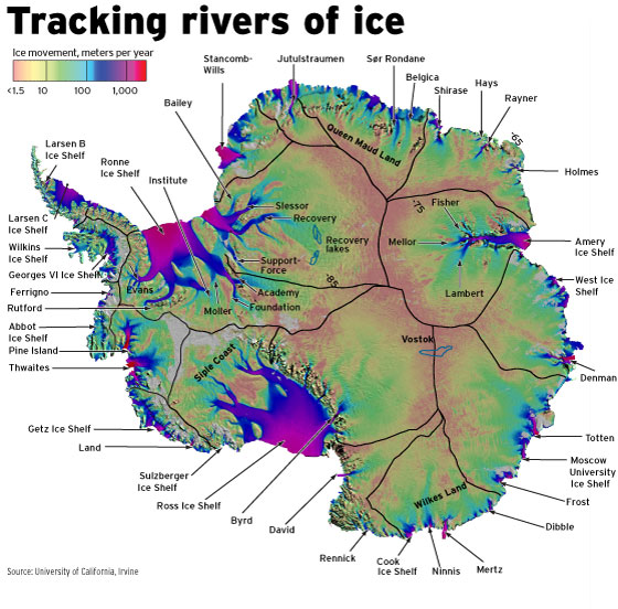
Rivers of Ice Antarctica
(Antarctic rivers of ice. Rising and warming waters from the Circumpolar Deep Water along continental margins have been increasingly coming into contact with ice shelf and glacier fronts that float upon or face the surrounding seas. The result has been much higher volumes of melt water contributions than expected from Antarctica. Image source: University of California.)
But the warm water rise is not just isolated to the Amundsen Sea. For Sunke also found that the warm water margin in the Weddell Sea on the opposite flank of West Antarctica was also rapidly on the rise. From 1980 to 2010, this warm water zone had risen from a depth of about 2100 feet to less than 1100 feet. A rapid advance toward another massive concentration of West Antarctic ice.
The impacts of a continued rise of this kind can best be described as chilling.
Sunke notes in an interview with National Geographic:
If this shoaling rate continues, there is a very high likelihood that the warm water will reach the Filchner Ronne Ice Shelf, with consequences which are huge.
Filchner Ronne, like the great Pine Island Glacier, has been calving larger and larger ice bergs during recent years. Should warm waters also destabilize this vast ice shelf another 1.5 feet of sea level rise would be locked in due to its direct loss. Including the massive inland glaciers that Filchner Ronne buttresses against a seaward surge, much larger than the ones near the Amundsen sea, would add a total of 10 feet worth of additional sea level rise.
Together, these destabilized zones would unleash much of West Antartica and some of Central Antartica, resulting in as much as 14 feet of sea level rise over a 100 to 200 year timeframe. This does not include Greenland, which is also undergoing rapid destabilization, nor does it include East Antarctica — which may also soon come under threat due to the encroachment of warm waters rising from the depths.
Are IPCC Projected Rates of Sea Level Rise Too Conservative?
The destabilization of glaciers along the Amundsen sea, the imminent threat to the Filchner Ronne Ice Shelf, and the less immediate but still troubling threat to East Antarctica’s glaciers, together with a rapidly destabilizing Greenland Ice Sheet, calls into question whether current IPCC predictions for sea level rise before 2100 are still valid.
IPCC projects a rise in seas of 1-3 feet by the end of this Century. But much of that rise is projected to come from thermal expansion of the world’s oceans — not from ice sheet melt in Antarctica and Greenland. Current rates of sea level rise of 3.3 milimeters each year would be enough to hit 1 foot of sea level rise by the end of this Century. However, just adding in the melting of the Filchner Ronne — a single large ice shelf — over the same period would add 4.4 milimeters a year. Add in a two century loss of the Amundsen glaciers — Pine Island and Thwaites — and we easily exceed the three foot mark by 2100.
Notably, this does not include the also increasingly rapid loss of ice coming from Greenland, the potential for mid century additions from East Antarctica, or lesser but still important additions from the world’s other melting glaciers.
Such more rapid losses to ice sheets may well reflect the realities of previous climates. At current CO2e levels of 481 ppm (400 ppm CO2 + methane and other human greenhouse gas additions) global sea levels were as much as 75-120 feet higher than they are today. Predicted greenhouse gas levels of 550 to 600 ppm CO2e by the middle of this century (Breaking 550 ppm CO2 alone by 2050 to 2060) are enough to set in place conditions that would eventually melt all the ice on Earth and raise sea levels by more than 200 feet. For there was no time in the past 55 million years when large ice sheets existed under atmospheric CO2 concentrations exceeding 550 parts per million.
Glaciologist Eric Rignot has been warning for years that the IPCC sea level rise estimates may well be too conservative. And it seems that recent trends may well bear his warnings out. If so, the consequences to millions of people living along the world’s coastlines are stark and significant. For the world, it appears we face the increasing likelihood of a near-term inland mass-migration of people and property. A stunning set of losses and tragedy starting now and ongoing through many decades and centuries to come.
Links:

Friday, May 25, 2012

Climate scientists discover new weak point of the Antarctic ice sheet

Climate scientists discover new weak point of the Antarctic ice sheet


WeakShelf1-250
Edge of the Filchner-Ronne Ice Shelf in the Weddell Sea, Photo: Ralph Timmermann, Alfred Wegener Institute

 by R&D Daily, May 15, 2012
The results of the climate modelers from the Alfred Wegener Institute will come as a surprise to the professional world with the majority of experts assuming that the consequences of global warming for Antarctica would be noticeable primarily in the Amundsen Sea and therefore in the western part of Antarctica.

“The Weddell Sea was not really on the screen because we all thought that unlike the Amundsen Sea its warm waters would not be able to reach the ice shelves. But we found a mechanism which drives warm water towards the coast with an enormous impact on the Fichner-Ronne Ice Shelf in the coming decades,' says Dr. Hartmut Hellmer, oceanographer at the Alfred Wegener Institute and lead author of the study.

Using different model calculations, he and his colleagues Dr. Frank Kauker, Dr. Ralph Timmermann and Dr. Jürgen Determann as well as Dr. Jamie Rae from Met Office, Hadley Centre, U.K.,  demonstrate that as a result of a chain reaction large ice masses could presumably slide into the ocean within the next six decades.

This chain reaction is triggered by rising air temperatures above the southeastern Weddell Sea.

“Our models show that the warmer air will lead to the currently solid sea ice in the southern Weddell Sea becoming thinner and therefore more fragile and mobile in a few decades," says  Frank Kauker. If this happens, fundamental transport processes will change.


/uploadedImages/RD/News/2012/05/WeakShelf2.jpg

click to enlarge
Illustration of the present conditions of the circulation in the Southern Weddell Sea: A consolidated sea-ice cover forms high-salinity shelf water (blue arrow) that prevents the warm coastal current (red arrow) from passing the coastal shelf and moving into the shelf ice cavity. Graphic: Alfred Wegener Institute
“This will mean that a hydrographic front in the southern Weddell Sea will disappear which has so far prevented warm water from getting under the ice shelf. According to our calculations, this protective barrier will disintegrate by the end of this century," explains Hellmer.

An inflow of warmer water beneath the Filchner-Ronne Ice Shelf will melt the ice from below.

“We expect the greatest melting rates near the so-called grounding line, the zone in which the ice shelf settles on the sea floor at the transition to the glacier. At this point the Filchner-Ronne Ice Shelf is melting today at a rate of around 5 m per year. By the turn of the next century the melt rates will rise to up to 50 m per year," says Hellmer’s colleague Jürgen Determann.

How the ice streams behind will react in the event of a melt of such enormous proportions is currently being investigated by Jürgen Determann. One thing is obvious, however: “Ice shelves are like corks in the bottles for the  ice streams behind them. They reduce the ice flow because they lodge in bays everywhere and rest on islands. If, however, the ice shelves melt from below, they become so thin that the  dragging surfaces become smaller and the ice behind them starts to move," explains Hellmer.

"If the high melting rates are completely compensated by  inland ice flow, this loss in mass would correspond to an additional rise in global sea level of 4.4 mm per year," adds Jürgen Determann. According to the latest estimates based on remote sensing data, global sea level rose for the period 2003-2010 at a rate of 1.5 mm per year due to melting of glaciers and ice shelves. This occurs in addition to the 1.7 mm per year due to thermal expansion of the oceans.

The forecasts of the current study are based on independent calculations of the ocean models BRIOS (Bremerhaven Regional Ice Ocean Simulations) and FESOM (Finite Element Sea Ice Ocean Model). The scientists used the atmospheric projections of the British Met Office Hadley Centre in Exeter as  forcing data. These included, for example, information on the future development of the wind and of the temperature in Antarctica.


/uploadedImages/RD/News/2012/05/WeakShelf3.jpg

click to enlarge
Illustration of simulated conditions for the year 2070: Due to thinning of the sea-ice cover less high-salinity shelf water is formed. This amount of shelf water is too small to prevent the warm coastal current from passing the continental slope. It fills the deeper part of the Filchner Ice Shelf cavitiy, bringing lot of warmth to the bottom side and the grounding line of the ice shelf, which starts to melt from below. Graphic: Alfred Wegener Institute
Hellmer and his colleagues have thoroughly checked  the model results for being realistic: “We started the BRIOS model in 1860 to see whether its results also  represent the current situation. We found that this condition was satisfied. For example, the water temperatures for the Weddell Sea predicted by BRIOS are close to those we have actually measured  in the recent past," says Ralph Timmermann, who adds, “The BRIOS model has been verified on many occasions in the past. It correctly predicts sea ice thickness, concentration, and drift as well as circulation patterns. And FESOM is well on the way to attaining BRIOS status. However, it has a far higher resolution, which is why we have to wait a long time until the computer has calculated several decades and more. BRIOS only needs less than a week for a century."

The study was conducted as part of the EU-funded research programme “Ice2sea." This project brings together scientists from 24 leading research institutions of the European Union and from Chile, Norway and Iceland. Together, the scientists aim for decoding the interactions between ice and climate and in this way facilitate more precise predictions about the effects of melting ice on sea level.

Ice2sea project

Twenty-first-century warming of a large Antarctic ice shelf cavity by a redirected coastal current.

Source: Alfred Wegener Institute

Wednesday, May 16, 2012

Warm ocean currents may threaten the stability of Antarctica's Filchner-Ronne Ice Shelf in the Weddell Sea if global temperatures continue to rise

Big Antarctic ice sheet appears doomed:  Warming climate predicted to trigger collapse of Filchner-Ronne shelf


Warm ocean currents may threaten the stability of Antarctica's Filchner-Ronne Ice Shelf in the Weddell Sea if global temperatures continue to rise.


access


Warm ocean currents may threaten the stability of Antarctica's Filchner-Ronne Ice Shelf in the Weddell Sea if global temperatures continue to rise.Ralph Timmermann, Alfred Wegener Institute


by 2100 by Devin Powell, Science News, May 10th, 2012  


The degradation of the historically stable Filchner-Ronne Ice Shelf would upset ice on land, triggering runaway melting over a vast region of the continent and accelerating global sea level rise.


“The loss of this ice shelf would be catastrophic,” says Ian Joughin, a glaciologist at the University of Washington. 


“We could be looking at tens of centimeters or even meters of sea level rise.” The finding is in stark contrast to recent research suggesting that sea level rise due to the melting of Greenland’s glaciers may fall short of worst-case scenarios (SN Online: 5/3/12).


“We need to start paying attention to this area of the West Antarctic Ice Sheet, which has so far been ignored,” says Laurence Padman, a physical oceanographer with Earth & Space Research in Corvallis, Ore.


Antarctica’s Filchner-Ronne Ice Shelf, located just east of the giant peninsula that extends toward South America, hasn’t caused much worry to date in terms of sea level rise. Anchored to the seafloor, the shelf extends outward over the Weddell Sea and covers an area the size of Sweden. The ice is hundreds of meters thick in places and shows signs of growth in recent years.


But climate change may soon reverse that trend, the new study suggests. Global air temperatures are projected to rise 4 degrees Celsius as the amount of carbon dioxide in the atmosphere increases over the next century. New simulations show the warmer air could thin and break up sea ice floating in Weddell Sea. Winds in the area would then transfer less energy to the ice and more energy directly into the ocean, churning up the water. In the researchers’ projected scenario, changing ocean currents push in warm waters that now circle Antarctica at a distance. By 2036 deep pulses of warm water reach up into shallow waters just offshore. By 2070 the heated currents completely displace the water that now fills the space between the ice shelf and the seafloor, raising temperatures by 2 degrees.


Heated in this way, the bottom of the shelf would disintegrate dramatically. Melting would jump roughly 20-fold from today’s 82 billion metric tons per year to 1.6 trillion metric tons per year by the end of the 21st century — or sooner.


“Having in mind that the presently observed CO2 emissions are larger than projected … the event can start even earlier,” says Hartmut Hellmer, a physical oceanographer at the Alfred Wegener Institute for Polar and Marine Research in Bremerhaven, Germany.


Warm water has already eaten away at other ice chunks in West Antarctica. Parts of the gigantic Pine Island Glacier lost four times as much ice in 2006 as in 1995. Air above the ice didn’t warm fast enough to explain this acceleration in melting, but in 2010 an autonomous submersible discovered a stream of warm water at the base of the glacier that could have done the job.


West of the Antarctic Peninsula, ocean-driven melting might already be widespread. Satellite observations show that several ice shelves on the Amundsen and Bellingshausen seas thinned between 2003 and 2008. Hotspots with the most melting were near seafloor troughs suitable for channeling warm waters blown in by the wind, researchers report in the April 26 Nature.


“People once thought that ice shelves change slowly over thousands of years,” says Hamish Pritchard, a glaciologist at the British Antarctic Survey in Cambridge. “We’re saying there’s a sensitivity to the oceans and to the climate that’s much greater than we previously realized.”


If the Filchner-Ronne Ice Shelf were to start shrinking, things could go from bad to worse very quickly. Radio waves beamed from an airplane show that the bedrock on which the ice is anchored tilts downward as it goes inland, researchers report online May 9 in Nature Geoscience. Retreating ice would thus pull back into ever-deeper waters, where more of the ice’s surface would be exposed and where higher pressures would speed melting.


“We believe this region is on the threshold of change,” says team member Martin Siegert, a glaciologist at the University of Edinburgh. “It needs some push to get over that [threshold], but we don’t believe that push has to be very hard to deliver a lot of deglaciation. ”


Siegert and his colleagues have also discovered that the shelf once shrank dramatically. A layer of sediments beneath ice farther inland must have been deposited during a time when the ice pulled back a couple hundred of kilometers, leaving the bedrock exposed to water. 


If history repeats itself, the stakes would be high. With the thinning or disappearance of the shelf, ice that now covers West Antarctica would flow faster out toward the sea. An extraordinary amount of water could be dumped into the world’s oceans.


http://www.sciencenews.org/view/generic/id/340580/description/Big_Antarctic_ice_sheet_appears_doomed 

Thursday, May 10, 2012

Scientists Discover New Site of Potential Instability in West Antarctic Ice Sheet under the Filchner-Ronne Ice Shelf


Scientists Discover New Site of Potential Instability in West Antarctic Ice Sheet

University of Texas -- Austin, May 10, 2012
AUSTIN, Texas — Using ice-penetrating radar instruments flown on aircraft, a team of scientists from the U.S. and U.K. have uncovered a previously unknown sub-glacial basin nearly the size of New Jersey beneath the West Antarctic Ice Sheet (WAIS) near the Weddell Sea. The location, shape and texture of the mile-deep basin suggest that this region of the ice sheet is at a greater risk of collapse than previously thought.
Location and Topography of New Sub-glacial Basin in West Antarctica
Bottom Image: This radar image of bedrock elevation reveals the new sub-glacial basin (purple and blue regions). The basin is divided into two components (A and B) and lies just inland of the West Antarctic Ice Sheet's grounding line (black line), where streams of ice flowing toward the Weddell Sea begin to float. Top Image: White box indicates location of bottom image. Pine Island Glacier (PIG) and Thwaites Glacier—two parts of the West Antarctic Ice Sheet previously studied by the U.S. and U.K. researchers—drain into the Amundsen Sea.
Team members at The University of Texas at Austin compared data about the newly discovered basin to data they previously collected from other parts of the WAIS that also appear highly vulnerable, including Pine Island Glacier and Thwaites Glacier. Although the amount of ice stored in the new basin is less than the ice stored in previously studied areas, it might be closer to a tipping point.
"If we were to invent a set of conditions conducive to retreat of the West Antarctic Ice Sheet, this would be it,” said Don Blankenship, senior research scientist at The University of Texas at Austin's Institute for Geophysics and co-author on the new paper. "With its smooth bed that slopes steeply toward the interior, we could find no other region in West Antarctica more poised for change than this newly discovered basin at the head of the Filchner-Ronne Ice Shelf. The only saving grace is that losing the ice over this new basin would only raise sea level by a small percentage of the several meters that would result if the entire West Antarctic Ice Sheet destabilized."
The study's co-authors also included Duncan Young, research scientist associate at the Institute for Geophysics.
The study, published this week in the journal Nature Geoscience, was carried out in a collaboration led by the University of Edinburgh with the British Antarctic Survey and the Universities of Aberdeen, Exeter and York, as well as The University of Texas at Austin.
"This is a significant discovery in a region of Antarctica that at present we know little about," said Professor Martin Siegert of the University of Edinburgh, who led the project. "The area is on the brink of change, but it is impossible to predict what the impact of this change might be without further work enabling better understanding of how the West Antarctic Ice Sheet behaves."
The seaward edge of the newly discovered basin lies just inland of the ice sheet's grounding line, where streams of ice flowing toward the sea begin to float.
Two features of the basin, which is entirely below sea level, are particularly worrisome to scientists: First, like a cereal bowl, its edges slope down steeply. If the grounding line begins to retreat upstream, seawater will replace it and more ice will begin to float. The study's authors predict that this positive feedback mechanism would sustain retreat of the ice sheet until eventually all of the ice filling the basin goes afloat. Second, the bed of the basin on which the ice rests is smooth. There are few big bumps, or "pinning points," to hold back sliding ice.
The newly discovered basin covers 20,000 square kilometers (7,700 square miles), nearly the size of New Jersey, and is well below sea level, nearly 2 kilometers (about 1.2 miles) deep in places.
In a related paper published simultaneously in the journal Nature, computer models reveal that the Weddell Sea region may experience warmer ocean conditions at the end of the 21st century, which could provide the trigger for ice sheet change.
For more information, contact: Marc Airhart, Geology Foundation, Jackson School of Geosciences, 512 471 2241.


