Blog Archive

Wednesday, March 31, 2010

Homes and dreams drown as waters rise in Rhode Island, Connecticut, Massachusetts

Homes and dreams drown as waters rise in Northeast

A tow truck operator checks on a car he is pulling out of a flooded road in Exeter, R.I., on Wednesday, March 31, 2010. Flooding on a scale rarely see AP – A tow truck operator checks on a car he is pulling out of a flooded road in Exeter, R.I., on Wednesday, …

CRANSTON, R.I. – Flooding on a scale rarely seen in New England forced hundreds of residents from their homes and businesses Wednesday, overwhelmed sewage systems and isolated communities as it washed out bridges and rippled across thoroughfares from Maine to Connecticut.

As three days of record-breaking rains tapered to a drizzle, forecasters warned the worst of widespread flooding was still ahead as rivers and streams had yet to crest — for the second time in a month.

In Rhode Island, which bore the brunt of the storm, residents were experiencing the worst flooding in more than 100 years. Stretches of Interstate 95, the main route linking Boston to New York, were closed and could remain so for days. Amtrak suspended some trains on its busy routes in the area because of water over the tracks.

Every resident of Rhode Island, a state of about 1 million, was asked to conserve water and electricity because of flooded sewage systems and electrical substations. Rising waters either stranded hundreds of people or sent them to shelters. Many of those who stayed behind appeared shell-shocked, still recovering from floods two weeks ago caused by as much as 10 inches of rain.

Angelo Padula Jr.'s auto restoration shop in West Warwick, Padula and Son Used Auto, stood in 10 feet of water from the Pawtuxet River — after 100 years in business, its likely death knell, Padula said.

"I think we're all done," he said. "If the federal government doesn't give us disaster money, I don't think we can ever come back from this. You're talking millions and millions of dollars in these businesses. Now I know how the people in New Orleans felt."

The flooding caps a month that set rainfall records across the region. Boston measured nearly 14 inches for March, breaking the previous record for the month, set in 1953. New Jersey, New York City and Portland, Maine, surpassed similar records. Providence registered its rainiest month on record, period, with a total of more than 15 inches of rain in March.

Gov. Don Carcieri called the flooding "unprecedented in our state's history." President Barack Obama had issued an emergency declaration late Tuesday for Rhode Island, ordering federal aid for relief and authorizing the Federal Emergency Management Agency to coordinate efforts.

Monica Bourgeois, 45, cried Wednesday morning as she stood outside her home in Cranston, where a sewer pump station gave out and hundreds of residents had evacuated by early Wednesday. The Pawtuxet had turned her lawn into a lake and flooded her basement with six feet of still-rising water.

"I have absolutely no idea how we're going to pay for this," she said. "I'm extremely, extremely worried. Do you know how much a new furnace costs? We're just praying to God for some help."

Similar concerns plagued residents throughout New England. National Guard troops went into action in Rhode Island, Massachusetts and Connecticut. A pond dam in Porter, Maine, let loose Tuesday morning, sending a torrent of water down country roads but injuring no one. Water covered roads in New Hampshire.
Stonington, Conn., a coastal town on a peninsula, was largely cut off as two of its three bridges went out. A bridge also gave out in Freetown, Mass., isolating about 1,000 residents.

Non-essential state workers in Rhode Island were given the day off, and state officials asked schools and private businesses to consider closing, as well. Officials in Warwick, where a water and sewage treatment plant failed, asked residents not to launder clothes or flush toilets. The state also asked people to stay off highways and local roads.

In Connecticut, the muddy earth beneath a Middletown apartment complex parking lot gave way, leaving two buildings teetering over the ravine of a river. Residents were taken to an emergency shelter at a high school.
Authorities also evacuated 50 units at a condominium complex in Jewett City in eastern Connecticut because a sewage treatment plant next door was under at least 4 feet of water.

In Massachusetts, the biggest concerns were in the southeastern part of the state, where a highway was closed. Heavy rains buckled a road in Fall River, near the Rhode Island border.

In Peabody, north of Boston, a court closed Wednesday because flooding made it inaccessible. Some residents there evacuated. Downtown businesses piled sandbags at their front doors and nearby streets were closed.

Demetri Skalkos, co-owner of McNamara's liquor store, said about three feet of water stood in the basement. He said he was worried about losing business over the traditionally busy Easter period.

"This is the Holy Week," he said. "... If we don't do business now, when are we going to do business?"
___
Contributing to this report were Associated Press writers Bob Salsberg in Boston, Michelle R. Smith in Providence and Clarke Canfield in Portland.

Link:  http://news.yahoo.com/s/ap/20100331/ap_on_bi_ge/us_severe_weather

Teleconference on Recent Developments in Climate Science with Robert Corell, Heidi Cullen and Matthew Nisbet

Media Advisory – For April 1, 2010
For Release on March 30, 2010                                                                       
 

Teleconference on Recent Developments in Climate Science:
Thursday, April 1, 2010, at 11 a.m. EDT

Experts provide latest insights and context on climate science, including research updates, and trends in extreme weather and public opinion

WASHINGTON, D.C. – A panel of experts will participate in a national teleconference on Thursday, April 1, at 11 a.m. EDT to provide environment and science reporters, editorial board members, and other journalists the latest insights and perspectives on the climate change debate.

As the U.S. Senate shifts its attention to climate and energy legislation, this session is intended to provide a balanced perspective on the climate science, including the latest reports on temperature trends, public opinion, and related issues.

The discussion will be moderated by the Honorable Sherwood Boehlert (R-NY), retired chair of the U.S. House of Representatives Science Committee, and a special advisor to the Project on Climate Science, a new initiative committed to collecting and disseminating high-quality scientific research and information on climate change.

Other speakers will include:


  • Robert Corell, Ph.D., Chair of the Arctic Climate Impact Assessment and Senior Fellow, American Meteorological Society, who will discuss the state of climate science and review the latest data on record warming trends;
  • Heidi Cullen, Ph.D., climatologist and correspondent at Climate Central, former Weather Channel climate expert and former research scientist at the National Center for Atmospheric Research, who will address recent extreme weather events in the United States and the relationship of natural climate patterns with long-term global warming trends.
  • Matthew Nisbet, Ph.D., an American University social scientist with expertise in public opinion research and the intersection between media, politics and science, will assess polling data on the public’s understanding of climate science and global warming as well as whether there is a consensus about global warming among climate scientists.
To participate in this press call, U.S.-based callers should dial 800-895-1549 (the international number is 785-424-1057). Please tell the operator that you are seeking the “science” conference call.

Note: This call is for media only, and will include a question and answer session for journalists.

RSVP to Abbey Franke at info@projectonclimatescience.org

For further information, please contact Richard Ades at rades@prismpublicaffairs.com or 202-207-3665, or Laura Gross at lgross@prismpublicaffairs.com or 202-207-3645

Tuesday, March 30, 2010

Records falls as rainstorm pounds U.S. East Coast flooding in Rhode Island, Massachusetts, Connecticut, March 30, 2010

Records falls as rainstorm pounds U.S. East Coast

Route 119 is closed as workers continue to fix a collapsed culvert in Littleton, Mass., Monday, March 29, 2010 where authorities asked some residents to voluntarily evacuate around Spectacle Pond as it continues to swell due to rain.
"Worst is still ahead of us," says Rhode Island Governor as second major storm pounds the Northeast with worst floods in more than 100 years.
by Eric Tucker, Associated Press, The Globe and Mail, March 30, 2010

Cranston, R.I.The second major rainstorm of the month pounded the Northeast on Tuesday, pushing rivers over their banks, closing roads and schools, prompting evacuations, and shattering at least one rainfall record.
Rhode Island Gov. Don Carcieri asked residents Tuesday afternoon to get home by dinnertime to avoid traveling in what officials expect to be the worst flooding to hit the state in more than 100 years.

“The worst is still ahead of us,” he said during a broadcast carried live on the state's major TV stations. “We're in a serious, serious situation.”

National Guard troops were activated in Massachusetts and Rhode Island, where neighborhoods still recovering from earlier flooding were again swamped after two days of unrelenting rain. Troops in Connecticut were put on alert.

A storm two weeks ago dropped as much as much as 10 inches of rain on the same region. The National Weather Service said nearly 13 inches of rain had fallen during March in Boston, breaking the previous record of 11 inches for the month set in 1953. New York City could also break its March record.

Providence had about 7.2 inches of rain from the current storm as of 10 a.m., pushing the monthly rainfall total to 37 centimetres and within an inch of the city's all-time monthly record, set in October 2005, the weather service said.

Scattered home evacuations were reported in Rhode Island, Connecticut and Massachusetts. No injuries had been reported in those states because of the storm as of midday Tuesday.

In one water-weary neighborhood along the Pawtuxet River in Cranston, basements were flooded and water at the end of one street was waist deep. One resident hung a sign: “FEMA + State + City of Cranston. Buy our houses.”

Brian Dupont, a real estate broker who owns two homes on the street, said Tuesday morning that he worried the water would rise to the first floors.

“Right now it's bad and getting worse,” said Dupont, who with his son put down 30 sandbags around the properties but was not sure how effective they would be.

“We've got a saying, ‘Its like trying to shovel against the tide.’ It's terrible, terrible,” said Dupont, who was afraid the home might now be unsellable.

Standing water pooled on or rushed across roads in the region, making driving treacherous and forcing closures. Steve Kass, spokesman for the Rhode Island Emergency Management Agency, said officials feared Interstate 95, a major East Coast thoroughfare, could end up under water in some sections.

In Maine, a dam in Porter let loose Tuesday morning, sending a torrent of water down country roads. One road ended up covered with 30 centimetres of water, but no evacuations or injuries were reported.

North of New York City, a man in his 70s drove past a barricade onto a flooded section of the Bronx River Parkway and had to be rescued from the roof of his truck, Westchester County police said. On Long Island, rain coupled with tides inundated a 32-kilometre stretch of oceanfront road in Southampton.

Water Row, a scenic road running along the Sudbury River in Wayland, Mass., lived up to its name Tuesday as water from the swollen river covered the street.

Bob Irving, the town's police chief and emergency management director, said Water Row and two other low-lying streets along the river had been closed, but no mandatory evacuations had been ordered yet.

During the three-day storm earlier in the month, amphibious Duck Boats like the ones used to ferry tourists around downtown Boston were deployed to take stranded residents to and from their homes. The boats could be used again if conditions deteriorate, Mr. Irving said.

In Connecticut, Norwich officials declared a state of emergency as the Yantic River continued to rise. Officials in Stonington ordered an evacuation of some areas as a precaution against rising flood waters.

Weather-related delays averaged three hours at Newark Liberty International Airport, and two hours at New York's La Guardia Airport, according to the Port Authority of New York and New Jersey. In New York City, a mudslide caused some interruptions on a commuter rail line in the Bronx.

The rain also caused a run on basement sump pumps at hardware and home improvement stores.

Jim Tatarczuk, manager of Amesbury Industrial Supply Co. Inc., told The Daily News of Newburyport, Mass., his store would normally stock about 130 pumps for the spring, but he has sold nearly double that already.

“There are people who are still pumping out from the old storm, and now we have more on its way,” he said.
U.S. President Barack Obama issued disaster declarations for many areas of New England to free up federal aid to residents and households for damages caused by late winter and early spring storms. Assistance can include grants for temporary housing and home repairs, and low-cost loans to cover uninsured property losses.

Link:  http://www.theglobeandmail.com/news/world/records-falls-as-rainstorm-pounds-us-east-coast/article1517343/

Thursday, March 25, 2010

NASA study finds Atlantic 'Conveyor Belt' not slowing overturning circulation of the global ocean

NASA Study Finds Atlantic 'Conveyor Belt' Not Slowing

overturning circulation of the global ocean Illustration depicting the overturning circulation of the global ocean. Throughout the Atlantic Ocean, the circulation carries warm waters (red arrows) northward near the surface and cold deep waters (blue arrows) southward. Image credit: NASA/JPL.  › Larger image
NASA'S JPL, PASADENA, March 25, 2010 -- New NASA measurements of the Atlantic Meridional Overturning Circulation, part of the global ocean conveyor belt that helps regulate climate around the North Atlantic, show no significant slowing over the past 15 years. The data suggest the circulation may have even sped up slightly in the recent past.

The findings are the result of a new monitoring technique, developed by oceanographer Josh Willis of NASA's Jet Propulsion Laboratory in Pasadena, Calif., using measurements from ocean-observing satellites and profiling floats. The findings are reported in the March 25 issue of Geophysical Research Letters.

The Atlantic overturning circulation is a system of currents, including the Gulf Stream, that bring warm surface waters from the tropics northward into the North Atlantic. There, in the seas surrounding Greenland, the water cools, sinks to great depths and changes direction. What was once warm surface water heading north turns into cold deep water going south. This overturning is one part of the vast conveyor belt of ocean currents that move heat around the globe.

Without the heat carried by this circulation system, the climate around the North Atlantic -- in Europe, North America and North Africa -- would likely be much colder. Scientists hypothesize that rapid cooling 12,000 years ago at the end of the last ice age was triggered when freshwater from melting glaciers altered the ocean's salinity and slowed the overturning rate. That reduced the amount of heat carried northward as a result.

Until recently, the only direct measurements of the circulation's strength have been from ship-based surveys and a set of moorings anchored to the ocean floor in the mid-latitudes. Willis' new technique is based on data from NASA satellite altimeters, which measure changes in the height of the sea surface, as well as data from Argo profiling floats. The international Argo array, supported in part by the National Oceanic and Atmospheric Administration, includes approximately 3,000 robotic floats that measure temperature, salinity and velocity across the world's ocean.

With this new technique, Willis was able to calculate changes in the northward-flowing part of the circulation at about 41 degrees latitude, roughly between New York and northern Portugal. Combining satellite and float measurements, he found no change in the strength of the circulation overturning from 2002 to 2009. Looking further back with satellite altimeter data alone before the float data were available, Willis found evidence that the circulation had sped up about 20 percent from 1993 to 2009. This is the longest direct record of variability in the Atlantic overturning to date and the only one at high latitudes.

The latest climate models predict the overturning circulation will slow down as greenhouse gases warm the planet and melting ice adds freshwater to the ocean. "Warm, freshwater is lighter and sinks less readily than cold, salty water," Willis explained.

For now, however, there are no signs of a slowdown in the circulation. "The changes we're seeing in overturning strength are probably part of a natural cycle," said Willis. "The slight increase in overturning since 1993 coincides with a decades-long natural pattern of Atlantic heating and cooling."

If or when the overturning circulation slows, the results are unlikely to be dramatic. "No one is predicting another ice age as a result of changes in the Atlantic overturning," said Willis. "Even if the overturning was the Godzilla of climate 12,000 years ago, the climate was much colder then. Models of today's warmer conditions suggest that a slowdown would have a much smaller impact now.

"But the Atlantic overturning circulation is still an important player in today's climate," Willis added. "Some have suggested cyclic changes in the overturning may be warming and cooling the whole North Atlantic over the course of several decades and affecting rainfall patterns across the United States and Africa, and even the number of hurricanes in the Atlantic."

With their ability to observe the Atlantic overturning at high latitudes, Willis said, satellite altimeters and the Argo array are an important complement to the mooring and ship-based measurements currently being used to monitor the overturning at lower latitudes. "Nobody imagined that this large-scale circulation could be captured by these global observing systems," said Willis. "Their amazing precision allows us to detect subtle changes in the ocean that could have big impacts on climate."

For more information about NASA and agency programs, visit: http://www.nasa.gov.
JPL is managed for NASA by the California Institute of Technology in Pasadena.
Alan Buis (818) 354-0474. Jet Propulsion Laboratory, Pasadena, Calif.. Alan.buis@jpl.nasa.gov

Link:   http://www.jpl.nasa.gov/news/news.cfm?release=2010-101

Rare tropical cyclone forms in deep South Atlantic Ocean off Argentina

Rare tropical cyclone forms

by wwakld, weatherwatch.co.nz, March 16, 2010

The second–ever known tropical cyclone in the South Atlantic Ocean can't escape satellite eyes, and this past weekend, the Geostationary Operational Environmental Satellite, GOES-12 captured a visible image of Tropical Storm 90Q which was located off the coast of Argentina.

GOES-12 satellite captured an image of the Tropical Storm 90Q on Friday last week when it was more than 2000kms east of Buenos Aires, Argentina.

GOES-12 is operated by the National Oceanic and Atmospheric Administration, and images are created by NASA's GOES Project, located at NASA's Goddard Space Flight Center, Greenbelt, Md.

Tropical Storm 90Q is now moving quickly in a southeasterly direction and is starting to interact with a mid-latitude frontal system.

By now the Southern Atlantic Ocean's second tropical storm in recorded history is expected to have merged with a cold front and just remain in the history books.


The TRMM satellite data was used to create a 3-D image of 90Q. The image showed some fairly high thunderstorm tops near the center of the storm reaching to heights above 12.5 km (over 41,010 feet). IMAGE: SSAI/NASA Goddard, Hal Pierce

Link:  http://www.weatherwatch.co.nz/content/rare-tropical-cyclone-forms

As global mean temperature increases, soils are releasing more CO2

Even soil feels the heat: Soils release more carbon dioxide as globe warms

ScienceDaily, March 25, 2010 — Twenty years of field studies reveal that as the Earth has gotten warmer, plants and microbes in the soil have given off more carbon dioxide. So-called soil respiration has increased about one-tenth of 1% per year since 1989, according to an analysis of past studies in the journal Nature.

The scientists also calculated the total amount of carbon dioxide flowing from soils, which is about 10-15% higher than previous measurements. That number -- about 98 petagrams of carbon a year (or 98 billion metric tons) -- will help scientists build a better overall model of how carbon in its many forms cycles throughout the Earth. Understanding soil respiration is central to understanding how the global carbon cycle affects climate.

"There's a big pulse of carbon dioxide coming off of the surface of the soil everywhere in the world," said ecologist Ben Bond-Lamberty of the Department of Energy's Pacific Northwest National Laboratory. "We weren't sure if we'd be able to measure it going into this analysis, but we did find a response to temperature."

The increase in carbon dioxide given off by soils -- about 0.1 petagram (100 million metric tons) per year since 1989 -- won't contribute to the greenhouse effect unless it comes from carbon that had been locked away out of the system for a long time, such as in Arctic tundra. This analysis could not distinguish whether the carbon was coming from old stores or from vegetation growing faster due to a warmer climate. But other lines of evidence suggest warming is unlocking old carbon, said Bond-Lamberty, so it will be important to determine the sources of extra carbon.

The Opposite of Photosynthesis

Plants are famous for photosynthesis, the process that stores energy in sugars built from carbon dioxide and water. Photosynthesis produces the oxygen we breathe as a byproduct. But plants also use oxygen and release carbon dioxide in the same manner that people and animals do. Soil respiration includes carbon dioxide from both plants and soil microbes, and is a major component of the global carbon cycle.

Theoretically, the biochemical reactions that plants and soil microbes engage in to produce carbon dioxide suggest that higher temperatures should result in more carbon dioxide being released. But unlike the amount of sunlight reaching Earth, soil respiration can't be measured from space and can't yet be simulated effectively with computer models.

So, the researchers turned to previous studies to see if they could quantify changes in global soil respiration. PNNL's Bond-Lamberty and his colleague Allison Thomson, working at the Joint Global Change Research Institute in College Park, Md., examined 439 soil respiration studies published between 1989 and 2008.

They compiled data about how much carbon dioxide has leaked from plants and microbes in soil in an openly available database. To maintain consistency, they selected only data that scientists collected via the now-standard methods of gas chromatography and infrared gas analysis. The duo compared 1,434 soil carbon data points from the studies with temperature and precipitation data in the geographic regions from other climate research databases.

After subjecting their comparisons to statistical analysis, the researchers found that the total amount of carbon dioxide being emitted from soil in 2008 was more than in 1989. In addition, the rise in global temperatures correlated with the rise in global carbon flux. However, they did not find a similar relation between precipitation and carbon.

Zooming In

Previous climate change research shows that Arctic zones have a lot more carbon locked away than other regions. Using the complete set of data collected from the studies, the team estimated that the carbon released in northern -- also called boreal -- and Arctic regions rose by about 7%; in temperate regions by about 2%; and in tropical regions by about 3%, showing a trend consistent with other work.

The researchers wanted to know if their data could provide more detailed information about each region. So they broke down the complete data set by regional climates and re-examined the smaller groups of data using different statistical methods. The regional data from the temperate and tropical climates produced results consistent with other results, such as more carbon being released at higher temperatures, but the boreal-Arctic climate data did not. In addition, removing only 10% of the boreal-Arctic data points was enough to invalidate the statistical significance of the boreal-Arctic result. Together, the results support the idea that more boreal data on regional climates is needed to reach statistical relevance.

"We identified an area where we need to do more work," said Thomson.

The authors designed the database so that other researchers could contribute to it. The paper describing the database can be found online in Biogeosciences < http://www.biogeosciences-discuss.net/7/1321/2010/bgd-7-1321-2010.html>.

Reference: Bond-Lamberty and Thomson, 2010. Temperature-associated increases in the global soil respiration record, Nature, March 25, 2009; doi: 10.1038/nature08930.

This research was supported by Pacific Northwest National Laboratory and by the Office of Biological and Environmental Research within the Department of Energy's Office of Science.

Link:  http://www.sciencedaily.com/releases/2010/03/100324141959.htm

Wednesday, March 24, 2010

S. A. Khan, J. Wahr, M. Bevis, I. Velicogna & E. Kendrick, GRL, Spread of ice mass loss into northwest Greenland observed by GRACE and GPS

Geophysical Research Letters, 37 (2010) L06501; doi: 10.1029/2010GL042460.

Spread of ice mass loss into northwest Greenland observed by GRACE and GPS

Shfaqat Abbas Khan (DTU Space, Department of Geodesy, National Space Institute, Copenhagen, Denmark), John Wahr (Department of Physics and Cooperative Institute for Research in Environmental Sciences, University of Colorado at Boulder, Boulder, CO, U.S.A.), Michael Bevis (School of Earth Sciences, Ohio State University, Columbus, OH, U.S.A.), Isabella Velicogna (Department of Earth System Science, University of California, Irvine, CA, and Jet Propulsion Laboratory, California Institute of Technology, Pasadena, CA, U.S.A.) and Eric Kendrick (School of Earth Sciences, Ohio State University, Columbus, OH, U.S.A.)

Abstract

Greenland's main outlet glaciers have more than doubled their contribution to global sea level rise over the last decade. Recent work has shown that Greenland's mass loss is still increasing. Here we show that the ice loss, which has been well-documented over southern portions of Greenland, is now spreading up along the northwest coast, with this acceleration likely starting in late 2005. We support this with two lines of evidence. One is based on measurements from the Gravity Recovery and Climate Experiment (GRACE) satellite gravity mission, launched in March 2002. The other comes from continuous Global Positioning System (GPS) measurements from three long-term sites on bedrock adjacent to the ice sheet. The GRACE results provide a direct measure of mass loss averaged over scales of a few hundred km. The GPS data are used to monitor crustal uplift caused by ice mass loss close to the sites. The GRACE results can be used to predict crustal uplift, which can be compared with the GPS data. In addition to showing that the northwest ice sheet margin is now losing mass, the uplift results from both the GPS measurements and the GRACE predictions show rapid acceleration in southeast Greenland in late 2003, followed by a moderate deceleration in 2006. Because that latter deceleration is weak, southeast Greenland still appears to be losing ice mass at a much higher rate than it was prior to fall 2003. In a more general sense, the analysis described here demonstrates that GPS uplift measurements can be used in combination with GRACE mass estimates to provide a better understanding of ongoing Greenland mass loss; an analysis approach that will become increasingly useful as long time spans of data accumulate from the 51 permanent GPS stations recently deployed around the edge of the ice sheet as part of the Greenland GPS Network (GNET). 

Received 10 January 2010; accepted 18 February 2010; published 19 March 2010.

Citation: Khan, S. A., J. Wahr, M. Bevis, I. Velicogna & E. Kendrick (2010), Spread of ice mass loss into northwest Greenland observed by GRACE and GPS, Geophys. Res. Lett., 37, L06501; doi: 10.1029/2010GL042460.

Link:  http://www.agu.org/pubs/crossref/2010/2010GL042460.shtml

Animation depicting the spread of ice loss into northwest Greenland observed by GRACE from 2003 through 2009, by John Wahr

The animation below, produced by CU-Boulder's Wahr, depicts the spread of ice loss into northwest Greenland observed by GRACE from 2003 through 2009. The shift in the color spectrum beginning with turquoise and ending in black over the seven-year time span shows the decreasing mass of ice relative to 2003. Courtesy John Wahr, University of Colorado.

To view animations of the GRACE mission, visit: www.csr.utexas.edu/grace/gallery/animations/

Title

“Spread of ice mass loss into northwest Greenland observed by GRACE and GPS”

Authors

Shfaqat Abbas Khan: DTU Space, Department of Geodesy, National Space Institute, Copenhagen, Denmark;
John Wahr: Department of Physics and Cooperative Institute for Research in Environmental Sciences, University of Colorado at Boulder, Boulder, Colorado, USA;
Michael Bevis and Eric Kendrick: School of Earth Sciences, Ohio State University, Columbus, Ohio, USA;
Isabella Velicogna: Department of Earth System Science, University of California, Irvine, California, USA; and Jet Propulsion Laboratory, California Institute of Technology, Pasadena, California, USA.

Contact information for co-authors

Shfaqat Abbas Khan, Tel. +45 61 10 80 98, Email: abbas@space.dtu.dk
Isabella Velicogna, Tel. +1 (949) 824-5419, Email: Isabella@uci.edu
John Wahr, Tel. +1 (303) 492-8349, Email: John.Wahr@colorado.edu

Greenland Ice Sheet Losing Mass on Northwest Coast

Greenland Ice Sheet Losing Mass on Northwest Coast

ScienceDaily, March 24, 2010 — Ice loss from the Greenland ice sheet, which has been increasing during the past decade over its southern region, is now moving up its northwest coast, according to a new international study.

Led by the Denmark Technical Institute's National Space Institute in Copenhagen and involving the University of Colorado at Boulder, the study indicated the ice-loss acceleration began moving up the northwest coast of Greenland starting in late 2005. The team drew their conclusions by comparing data from NASA's Gravity and Recovery Climate Experiment satellite system, or GRACE, with continuous GPS measurements made from long-term sites on bedrock on the edges of the ice sheet.

The data from the GPS and GRACE provided the researchers with monthly averages of crustal uplift caused by ice-mass loss. The team combined the uplift measured by GRACE over United Kingdom-sized chunks of Greenland while the GPS receivers monitor crustal uplift on scales of just tens of miles. "Our results show that the ice loss, which has been well documented over southern portions of Greenland, is now spreading up along the northwest coast," said Shfaqat Abbas Khan, lead author on a paper that will appear in Geophysical Research Letters.

The team found that uplift rates near the Thule Air Base on Greenland's northwest coast rose by roughly 1.5 inches, or about 4 centimeters, from October 2005 to August 2009. Although the low resolution of GRACE -- a swath of about 155 miles, or 250 kilometers across -- is not precise enough to pinpoint the source of the ice loss, the fact that the ice sheet is losing mass nearer to the ice sheet margins suggests the flows of Greenland outlet glaciers there are increasing in velocity, said the study authors.

"When we look at the monthly values from GRACE, the ice mass loss has been very dramatic along the northwest coast of Greenland," said CU-Boulder physics Professor and study co-author John Wahr, also a fellow at CU-Boulder's Cooperative Institute for Research in Environmental Sciences.

"This is a phenomenon that was undocumented before this study," said Wahr. "Our speculation is that some of the big glaciers in this region are sliding downhill faster and dumping more ice in the ocean."

Other co-authors on the new GRL study included Michael Bevis and Eric Kendrick from Ohio State University and Isabella Velicogna of the University of California-Irvine, who also is a scientist at NASA's Jet Propulsion Laboratory. GRL is published by the American Geophysical Union.

A 2009 study published in GRL by Velicogna, who is a former CU-Boulder research scientist, showed that between April 2002 and February 2009, the Greenland ice sheet shed roughly 385 cubic miles of ice. The mass loss is equivalent to about 0.5 millimeters of global sea-level rise per year.

"These changes on the Greenland ice sheet are happening fast, and we are definitely losing more ice mass than we had anticipated, " said Velicogna. "We also are seeing this ice mass loss trend in Antarctica, a sign that warming temperatures really are having an effect on ice in Earth's cold regions."

Researchers have been gathering data from GRACE since NASA launched the system in 2002. Two GRACE satellites whip around Earth 16 times a day separated by 137 miles and measure changes in Earth's gravity field caused by regional shifts in the planet's mass, including ice sheets, oceans and water stored in the soil and in underground aquifers.

"GRACE is unique in that it allows us to see changes in the ice mass in almost real time," said Velicogna. "Combining GRACE data with the separate signals from GPS stations gives us a very powerful tool that improves our resolution and allows us to better understand the changes that are occurring."

In addition to monitoring the Thule GPS receiver in northwest Greenland as part of the new GRL study, the team also is taking data from GPS receivers in southern Greenland near the towns of Kellyville and Kulusuk. An additional 51 permanent GPS stations recently set up around the edges of the Greenland ice sheet should be useful to measure future crustal uplift and corresponding ice loss, said Wahr.

"If this activity in northwest Greenland continues and really accelerates some of the major glaciers in the area -- like the Humboldt Glacier and the Peterman Glacier -- Greenland's total ice loss could easily be increased by an additional 50 to 100 cubic kilometers (12 to 24 cubic miles) within a few years," said Khan.

The study was funded by NASA and the National Science Foundation.

Greenland is about one-fourth the size of the United States and the massive ice sheet covers about 80 percent of its surface. It holds about 20 percent of the world's ice, the equivalent of about 21 feet of global sea rise. Air temperatures over the Greenland ice sheet have increased by about 4 degrees Fahrenheit since 1991, which most scientists attribute to a build-up of greenhouse gases in the atmosphere.

A 2006 study by Wahr and Velicogna using the GRACE satellite indicated that Greenland lost roughly 164 cubic miles of ice from April 2004 to April 2006 -- more than the volume of water in Lake Erie.

Link:  http://www.sciencedaily.com/releases/2010/03/100323161819.htm

Tuesday, March 23, 2010

Nope! For the thousandths time, it is not the Sun!

Nope!  For the thousandths time, it is not the Sun!


http://www.flickr.com/photos/47410290@N04/

Joseph Romm: Study reports, “It is clear … that the precipitous decline in September sea ice extent in recent years is mainly due to the cumulative loss of multiyear ice”

Study: “It is clear … that the precipitous decline in September sea ice extent in recent years is mainly due to the cumulative loss of multiyear ice.”


Physicist: "If temperatures change just a few tenths of a degree then this oh-so-thin ice cap is doomed."

Joseph Romm, Climate Progress, March 22, 2010

Memo to media:  Ignore the misreporting on the Arctic that focuses on sea-ice extent or area.  The big Arctic news is the staggering decline in multiyear ice — ice volume. No study has yet been published undermining our understanding that human emissions are the primary cause of that long-term decline — a decline that shows no sign of reversal.


http://climateprogress.org/wp-content/uploads/2009/07/Arctic-Ice-Volume-.gif

The real news from the Arctic is the staggering decline in thicker, multi-year ice [red line] — as seen in the above figure from leading cryoscientists who authored the 2009 study, “Thinning and volume loss of the Arctic Ocean sea ice cover: 2003–2008” (discussed here).  Studies that focus on trying to correlate sea ice extent (i.e. area) with variables that might reduce ice cover border on purely pointless right now because:
  1. Trends in multi-year ice — ice volume — are what matter most in terms of the long-term survivability of the Arctic ice in the summer (see New study supports finding that “the amount of [multi-year] sea ice in the northern hemisphere was the lowest on record in 2009″).
  2. It now appears that an unfortunate trick of Nature helped hide the ongoing decline of Arctic ice from satellite and other measurements — measurements that suggested two-dimensional recovery of sea ice extent in 2009.  See the study Perennial pack ice in the southern Beaufort Sea was not as it appeared in the summer of 2009.”
The latest media mashup began with a new study in Geophysical Research Letters (subs. req’d), “Influence of winter and summer surface wind anomalies on Summer Arctic sea ice extent.”  The study, by Masayo Ogi et al., finds that:
... the combined effect of winter and summer wind forcing accounts for 50% of the variance of the change in September Arctic sea ice extent from one year to the next (ΔSIE) and it also explains roughly 1/3 of the downward linear trend of SIE over the past 31 years.
That became a Guardian story by David Adam with an especially misleading subhead:

Wind contributing to Arctic sea ice loss, study finds

New research does not question climate change is also melting ice in the Arctic, but finds wind patterns explain steep decline
And of course we have a Daily Mail story by the infamous “Daily Mail Reporter”:

Arctic winds and not global warming ‘responsible for much of record loss of sea ice’

As an aside, I understand why “Daily Mail Reporter” wants to stay anonymous — he or she is a dreadful journalist at a dreadful newspaper (see “DailyMailGate: Error-riddled articles and false statements destroy Daily Mail’s credibility”).

The anti-science disinformers are dancing over this study, but they are dancing on thin ice — like a certain ice skater we know.

First off, this study isn’t even news!  As I blogged almost 2 years ago, a GRL study, “What drove the dramatic retreat of arctic sea ice during summer 2007?” concluded:
… preconditioning, anomalous winds, and ice-albedo feedback are mainly responsible for the retreat. Arctic sea ice in 2007 was preconditioned to radical changes after years of shrinking and thinning in a warm climate.The Arctic Ocean lost additional 10% of its total ice mass in which 70% is due directly to the amplified melting and 30% to the unusual ice advection, causing the unprecedented ice retreat. Arctic sea ice has entered a state of being particularly vulnerable to anomalous atmospheric forcing.
So the June 2008 GRL study found 30% of the sharp drop in sea ice in 2007 was due to “unusual ice advection” — and the new study says 1/3 of the downward linear trend in SIE is due to wind forcing.  The new study seems to confirm the older study (without ever referencing it).

The bigger point is the long-term trend is driven by human-driven warming, which makes the thinning ice more vulnerable to anomalous winds (assuming of course that the winds are anomalous and not themselves driven by climate change).  So the story is an old one.  What’s new is the disinformers are better at spinning these studies, and the media has gotten worse at actually reporting the science.

Indeed, Masayi Ogi also led another recent study (12/08), “Summer retreat of Arctic sea ice: Role of summer winds” (subs. req’d) that concluded:
The six summers that exhibited highest values of the SLP [sea level pressure] index (1995, 1998, 1999, 2005, 2007 and 2008) were all in the last half of the record. September SIE reached record lows in three of these years (1995, 2005, and 2007), and it nearly tied the record in 2008.  Yet it is clear from Figure 4c that the precipitous decline in September SIE in recent years is mainly due to the cumulative loss of multiyear ice:  summertime SLP anomalies have played an important role in setting the timing of record lows, but the long term trend is mainly due to preconditioning.
In other words, Ogi’s studies do nothing whatsoever to undermine the view that the long-term trend in Arctic sea ice — extent and volume — is being driven by human-caused warming.

That paragraph and the new study make clear the SLP index and winds have been higher more recently.  As the Guardian notes, “These winds have increased recently, which could help explain the apparent acceleration in ice loss.”  The climate is changing everywhere and humans are the primary cause.  Unless the authors (or anyone else) can show that this increase in winds is not also due to climate change, then their study again does nothing to undermine the view that the long-term trend is being driven primarily by human-caused warming.


Finally, the latest study is based on correlating sea ice extent (SIE) with other factors, like Arctic winds.  But another recent study — “Perennial pack ice in the southern Beaufort Sea was not as it appeared in the summer of 2009” (subs. req’d) by Barber et al. — suggests that standard measures of SIE extent may be unreliable.  I discussed that study here:  “Where on Earth is it unusually warm? Greenland and the Arctic Ocean, which is full of rotten ice.”  It found:
In September 2009 we observed a much different sea icescape in the Southern Beaufort Sea than anticipated, based on remotely sensed products. Radarsat derived ice charts predicted 7 to 9 tenths multi-year (MY) or thick first-year (FY) sea ice throughout most of the Southern Beaufort Sea in the deep water of the Canada Basin. In situ observations found heavily decayed, very small remnant MY and FY floes interspersed with new ice between floes, in melt ponds, thaw holes and growing over negative freeboard older ice. This icescape contained approximately 25% open water, predominantly distributed in between floes or in thaw holes connected to the ocean below. Although this rotten ice regime was quite different than the expected MY regime in terms of ice volume and strength, their near-surface physical properties were found to be sufficiently alike that their radiometric and scattering characteristics were almost identical.
Yes, satellite (and other) measurements of Arctic sea ice extent were apparently deceived by rotten ice.  [Hmm, is that why they call it rotten?]   You might even say that an unfortunate trick of Nature helped hide the decline of Arctic ice:
This case of mistaken identity is physically explained by the factors which contribute to the return to Radarsat-1 from the two surfaces; both ice regimes had similar temperature and salinity profiles in the near-surface volume, both ice types existed with a similar amount of open water between and within the floes, and finally both ice regimes were overlain by similar, recently formed new sea ice in areas of negative freeboard and in open water areas. The fact that these two very different ice regimes could not be differentiated using Radarsat-1 data or in situ C-band scatterometer or microwave radiometer measurements, has significant implications for climate studies and for marine vessel navigation in the Canada Basin.
Given Barber’s work calling into question traditional measures of SIE, I don’t know how much faith one can put in statistical analyses that correlate SIE with other variables.  Barber himself says:
I would argue that, from a practical perspective, we almost have a seasonally ice-free Arctic now, because multiyear sea ice is the barrier to the use and development of the Arctic,” said Barber [Canada's Research Chair in Arctic System Science at the University of Manitoba].
Revkin has another Goldilocks post leaping on this study, linking to some of my much older posts, not the ones about Barber’s work.  He quotes one expert noting that the unusual conditions in the Arctic this winter — in particular the highly negative Arctic oscillation — may lead to less ice retreat.  Certainly it might lead to less observed sea ice retreat, but then again, this is likely to be the hottest year on record — and certainly we now know that atmospheric conditions do have an impact on year-to-year fluctuations in apparent SIE — so the jury is out on this summer.  In any case, we also know the traditional measurements of SIE may not be reliable and thus may well lowball the actual retreat.

Most importantly, we know that thickness matters much more than area.  And in that regard, we have seen no significant recovery.  Nor are we likely to, according to one of Revkin’s own experts, “Rhett Herman, a physics professor at Radford University, [who] has been leading students on an expedition each spring break to study the condition of the sea ice off the coast near Barrow, Alaska.”  Last week, Revkin quoted Herman:
We’re also seeing just how frighteningly thin the ice is. When asked about the thickness of the north polar ice cap many people say things such as “hundreds of feet” and “thousands of feet” and “very thick like the South Pole.” None of these are true. The average thickness of the sea ice over the entire north polar ice cap is only a few meters! There isn’t much ice here, and that’s a major problem. If temperatures change just a few tenths of a degree then this oh-so-thin ice cap is doomed.
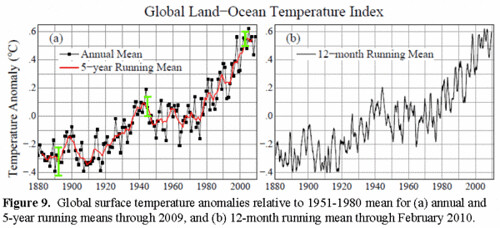
Well, we’re pretty much stuck with another 0.6 °C warming even if GHG concentrations don’t rise further — and NASA just reported, “there has been no reduction in the global warming trend of 0.15-0.20 °C/decade that began in the late 1970s.”

Many other leading experts share a similar view.  Peter Wadhams, head of the polar ocean physics group at the University of Cambridge, “believes the ice, which has been a permanent feature for at least 100,000 years, is now so thin that almost all of it will disappear in about a decade.”

Back in October, National Snow and Ice Data Center Research Scientist Walt Meier wrote me:
There is significant natural variability in the climate system, and particularly the sea ice. It is only by looking at long-term trends, after the short-term variability is averaged out, that you can make any judgments on long-term climate factors…
In the short term, winds can play an important role in the sea ice extent. If there are winds pushing the ice edge “inward,” then you either increase the seasonal decline or slow (or even temporarily reverse) the seasonal increase, depending on the season.
What about NSIDC director’s Mark Serreze “death spiral” of Arctic ice metaphor?  I noted back then that the NYT’s Revkin had written:
So the “death spiral of the Arctic ice system” could well be more like a series of descending loop the loops.
Meier wrote:
Andy Revkin’s comment is quite apt. We don’t expect to see a continual downward trend, there will some fits and starts, but the overall trend will continue to be down.
NSIDC director Serreze then wrote me that “I share Walt’s views.”

So the ice cap is apparently doomed — and the overwhelming majority of CP readers will probably live to see an ice-free summer Arctic.  I’ll end with this figure of mean monthly Ice Volume for the Arctic Ocean from a release by several scientific institutions:
http://climateprogress.org/wp-content/uploads/2010/01/Arctic-Volume1.gif

I still like my odds on a 90% ice free Arctic by 2020 (see “Another big climate bet — Of Ice and Men“).  By then, I assume they’ll have figured out how to deal with Nature’s sea-ice-decline-hiding trick — or there will simply be too little ice for anybody to be fooled.

Link to above post at Climate Progress:  http://climateprogress.org/2010/03/22/thin-ice-arctic-winds-sea-ice-extent-global-warming/

Selected comments:

Joe,

I’m sure Rhett Herman, who contributed the Dot Earth “postcard” on his students’ fieldwork, will readily admit that while he’s a great teacher (and that’s why that post was done) he is not a heavily published specialist on sea-ice trends and drivers. Stacking his informal comment against the input of a heap of published sea-ice specialists (see my coverage since 2000) seems a bit strained?

[JR: Honestly, Andy. You quote this guy at length on your blog, and now walk away from him. You always tout your group of Arctic experts. How am I supposed to know which experts you quote that you believe and which you don't! I did NOT stack his comment against anything. His comment is consistent with many experts I have quoted. This quote just happened to be new and from DotEarth. How about this -- Peter Wadhams, head of the polar ocean physics group at the University of Cambridge, “believes the ice, which has been a permanent feature for at least 100,000 years, is now so thin that almost all of it will disappear in about a decade“:]

The reason I didn’t write on Dave Barber’s paper when it came out (even though he was featured in our 2005 Discovery-Times “Arctic Rush” documentary and is a highly regarded scientist), is that I got a lot of pushback from a batch of Arctic Ocean ice specialists who immediately said that the Beaufort is a special case and cited various reasons to handle those findings cautiously. I may revisit and query Dr. Barber and them anew. That’s how I try to avoid what I call “whiplash journalism” (or blogging). Covering every paper can lead to real neck trauma when focused on the more complicated parts of climate science (even as the basics are clear).

[JR: So you only cover the published peer-reviewed papers that your group of experts are okay with? Awesome. Essentially, you are negatung the peer review process. So these "batch of Arctic Ocean ice specialists" apparently aren't reviewers who can affect the content of the piece before it is published.
BTW, aren't you now a blogger? What was the point of that comment?

And you are missing half the reason I'm quoting Barber -- his research calls into question the accuracy of traditional SIE measurement, which in turn calls into question any effort to do correlations between SIE and other variables! I can see why that by bother your specialists.]

I don’t imagine you tried contacting any other ice scientists before publishing your posts on the Beaufort finding? (I know, my need to check things out is just the old retro journalist trait in me.)

[JR: Again, if I understand your methodology, you ask your group of experts about peer-reviewed science and if they don't like it then maybe you don't write about it. Not what I do. Sometimes I talk to other scientists, sometimes I don't. Depends on the study. You don't actually have to contact other scientists to write about a new peer-reviewed paper -- especially if you are very familiar with the peer-reviewed literature and especially if this study pretty much agrees with one that was written two years ago! In this case, it seemed clear to me it was being misreported, and I wanted to correct the record.]

Finally, you forgot to mention the paragraph in my post where I expressly described the great spasm-like flushes of the true multi-year (as opposed to young two-year-old) ice you focus on. Those big flushes show the situation up there is not nearly as simple as some would like it to be. Don’t take my word for it, though. This animation from Ignatius Rigor at U. of Washington vividly shows the big pulses of lost meters-thick ice (long before the losses that you highlight above):
http://www.youtube.com/watch?v=Co68_tod0dQ

[JR: Awesome. Looks like a death spiral for me. I take it this is one of the experts you quote whom you actually believe. Is this in the peer-reviewed literature, because I would like the link, if so. In any case, the last time I checked, 1989 was the tail end of what was the hottest decade on record at the time, before the 1990s became the hottest decade on record, and before the 2000s overtook them both. I don't focus on two-year-old ice -- I do cite peer-reviewed literature on multiyear ice.

I can't imagine anybody reading this post would come away with the impression that I think this situation is "simple." Obviously the apparent SIE is affected by many things year-to-year, just like the apparent global temperature. But the ice volume appears much less susceptible to such fluctuations and appears to be doomed.]

Here’s video I shot of one of the processes that generates such ice (also a function of ice motion, not just temperature):
http://www.youtube.com/watch?v=axsSexPoSR0

I really do think you need to take a field trip sometime.


Aaron Lewis March 22, 2010 at 9:15 pm says:
Volume is important, but the heat content of the remaining sea ice is also of interest. Dr. Barber suggests, and satalite data confirms that the remaining ice may already have absorbed most of the heat it needs to melt. And, this is in situ HEATING not wind. Cold hard ice would have been strong enough to not blow through the straits. The same satalite data tells me that the Ross ice shelf and the sea ice on the Weddle sea are also absorbing heat from the warming oceans below.

The figures below (Rothrock, et al., 1999, and Kwock & Rothrock, 2009) show sea ice thickness has substantially declined. Using data from submarine cruises, Rothrock and collaborators determined that the mean ice draft at the end of the melt season in the Arctic has decreased by about 1.3 meters between the 1950s and the 1990s.

http://www2.sunysuffolk.edu/ mandias/ global_warming/ images/ sea_ice_draft.gif

When combining this data with recent satellite data:

http://www2.sunysuffolk.edu/ mandias/ global_warming/ images/ sea_ice_draft_composite.gif

“The overall mean winter thickness of 3.64 m in 1980 can be compared to a 1.89 m mean during the last winter of the ICESat record—an astonishing decrease of 1.75 m in thickness. Between 1975 and 2000, the steepest rate of decrease is 0.08 m/yr in 1990 compared to a slightly higher winter/summer rate of 0.10/0.20 m/yr in the five-year ICESat record (2003–2008). Prior to 1997, ice extent in the DRA was >90% during the summer minimum. This can be contrasted to the gradual decrease in the early 2000s followed by an abrupt drop to <55% during the record setting minimum in 2007. This combined analysis shows a long-term trend of sea ice thinning over submarine and ICESat records that span five decades." 

Daily Kos: Not to be forgotten -- Dealing with Climate Change

Not to be forgotten: Dealing with Climate Change

While the focus has (rightfully) been on HCR, climate change news hasn't been fully dead. In fact, it may have been easy to miss a couple notes:
  1. 2010 is very likely to be the hottest year on record. This was predicted based on the presence of a modest El Nino and as I've shown below the fold, the prediction's so far been borne out.
  1. Skeptical Science and other sites are being targeted for hacks.
  1. NASA has another paper coming out that the last decade was damn hot.
Join me for figures and more below the jump.
  1. Stanford study confirming that media coverage of climate change is presenting a false balance that misleads the public.
  1. (Apologies if this link doesn't work - my school has an institutional subscription to Science Magazine) New study shows that burning brush may help forests retain more CO2 by promoting larger tree health.
The NASA paper (hasn't fully gone through peer review yet, so some things may get changed, but the main conclusion is valid) notes that warming didn't go away in the 2000's (dur), and they predict a high likelihood of 2010 being a record year, due to the moderate El Nino and other factors (note that the 1998 El Nino was significantly stronger - I haven't been able to find a decent graph comparing the two, so this table will have to suffice).

GISS1
Figure 1. It's warming up! 

UAH-winter-2010
Figure 2. 2010 running satellite average. Circle indicates the latest day. Note how 2010 is almost exclusively higher than any previous year. (Apologies that the figure is for about a month ago - March hasn't been any different and I can't make the figures into GIF or JPG myself).

Ap
Figure 3. For better or worse, the current solar minimum appears to be ending. This could mean that the current negative forcing by the solar cycle could reverse.

Temp_vs_TSI_2009
Figure 4. This one's been posted before, but temperature vs. solar cycle. Useful for showing that the solar cycle hasn't been responsible for the warming. 

Total-Heat-Content
More on note 4.
ClimateChangeReporting
Figure 5. Another one that's been posted a lot, but as a reminder, most of the excess heat that's trapped by CO2 and methane and other GHG's ends up in the oceans.

Hopefully the passage of HCR will help grease the skids to get other stuff moving. If dems use the momentum to get meaningful legislation through, then I'll be the first to applaud them. Or one of the first.

ETA: Request. I have seen but couldn't find now an updated figure with temps until mid or late March on the Satellite record and also a figure showing El Nino strength is dissipating (small graph). If anyone has either the link or the figure please post so I can edit them in. Thanks!

Link:  http://www.dailykos.com/storyonly/2010/3/22/845364/-Not-to-be-forgotten:-Dealing-with-Climate-Change

Andy Revkin misses the point entirely of the rather horrifying animation by Ignatius Rigor of multi-year sea ice loss in the Arctic

Extreme loss of multi-year ice in the Arctic
Ignatius Rigor, who studies Arctic ice and climate at the University of Washington, has created an animation showing how the oldest thickest sea ice has been progressively flushed from the Arctic Ocean over the last two decades.


Link:  http://www.youtube.com/watch?v=Co68_tod0dQ

Monday, March 22, 2010

John Cook: What CO2 level would cause the Greenland ice sheet to collapse?

What CO2 level would cause the Greenland ice sheet to collapse?

by John Cook, Skeptical Science, March 22, 2010

A matter of concern is the potential instability of the Greenland and Antarctic ice sheets. If the Greenland ice sheet was to completely collapse, it would contribute as much as 7 metres sea level rise. Similarly, the West Antarctic ice sheet would contribute around 6 metres sea level rise. East Antarctica would contribute 70 metres of sea level rise but is less prone to collapse. Consequently, how these ice sheets respond to warming temperatures is a crucial area of research. A new paper (Stone 2010) has been published that estimates that the CO2 level that will lead to collapse of the Greenland ice sheet is between 400 to 560 parts per million (ppm). At our current rate, we should pass 400 ppm within 10 years.

While there are uncertainties over the specifics of ice sheet behaviour, there are several lines of independent evidence that paint a consistent picture of how ice sheets will respond to global warming. Focusing on Greenland, what do observations tell us has been happening to the Greenland ice sheet? Satellites use gravity data to measure the total mass balance and have found the ice sheet is losing ice mass at an accelerating rate (Velicogna 2009). 


Figure 1. Ice mass changes for the Greenland ice sheet estimated from GRACE satellite measurements. Unfiltered data are blue crosses. Data filtered for the seasonal dependence are shown as red crosses. The best-fitting quadratic trend is shown as a green line (Velicogna 2009).

How can we know how the Greenland ice sheet will behave over a longer time period? We can determine this by looking at how the ice sheet has responded in the past. Some of the more optimistic emission scenarios from the IPCC predict warming of 1-2 °C. The last time temperatures were this high were 125,000 years ago. At this time, sea levels were over 6 metres higher than current levels (Kopp 2009). This tells us that the Greenland and Antarctic ice sheets are highly sensitive to sustained, warmer temperatures and that in upcoming centuries, we can expect sea level rise in the range of metres, not centimetres.

Further light is shed on Greenland ice sheet stability in a new paper The effect of more realistic forcings and boundary conditions on the modelled geometry and sensitivity of the Greenland ice-sheet (Stone 2010). This paper uses updated data on bedrock topography and ice thickness to produce more accurate modelling results of Greenland ice sheet behaviour. They model how the Greenland ice sheet will respond to three different scenarios with atmospheric CO2 held at 400 ppm, 560 ppm and 1120 ppm. The simulations are run over a 400-year period.

Although not completely collapsed, the 400-ppm ice-sheet loses ice mass in the north of the island, with a total reduction in ice volume ranging between 20 to 41%. Note:  due to the large inertia of the Greenland ice sheet, this mass loss doesn't happen at the moment CO2 levels reach 400 ppm but over a period of centuries. Under a 560 ppm climate, the Greenland ice sheet loses between 52 to 87% of its ice volume. If CO2 reaches 1120 ppm, there is almost complete elimination of the Greenland ice sheet with loss between 85 to 92%. The important result from this paper is that there is a critical threshold where the Greenland ice sheet becomes unstable somewhere between 400 and 560 ppm.

This is a large uncertainty range and one imagines there will be much research in the next few years to reduce the uncertainty. However, the 400-560 ppm range is put into perspective when you look at the projected CO2 levels for the various IPCC scenarios. The business as usual scenario has CO2 levels reaching 1000 ppm by 2100. Even the most optimistic scenario tops 500 ppm by 2100.

Projected CO2 levels for various IPCC emission scenarios
Figure 3. Atmospheric CO2 concentrations as observed at Mauna Loa from 1958 to 2008 (black dashed line) and projected under the 6 IPCC emission scenarios (solid coloured lines). (IPCC Data Distribution Centre)

Of course, Figure 3 displays projected scenarios. What has been happening in the real world? Observed CO2 emissions in recent years have actually been tracking close to or above the worst case scenario.


Figure 4. Observed global CO2 emissions from fossil fuel burning and cement production compared with IPCC emissions scenarios. The coloured area covers all scenarios used to project climate change by the IPCC.

Satellite measurements, paleoclimate data and ice sheet modelling all paint a consistent picture. Global warming is destabilising the Greenland ice sheet which is highly sensitive to sustained warmer temperatures. Our current trajectory with CO2 emissions will likely cause at least several metres sea level rise from the Greenland ice sheet over the next few centuries. Of course, we shouldn't forget that this estimate doesn't include Antarctica -- the Antarctic ice sheet is also losing ice at an accelerating rate.

Link:  http://www.skepticalscience.com/What-CO2-level-would-cause-Greenland-ice-sheet-collapse.html

E. J. Stone et al., The effect of more realistic forcings and boundary conditions on the modelled geometry and sensitivity of the Greenland ice-sheet

The Cryosphere Discuss., 4 (2010) 233-285; www.the-cryosphere-discuss.net/4/233/2010/
© Author(s) 2010. This work is distributed under the Creative Commons Attribution 3.0 License.


The effect of more realistic forcings and boundary conditions on the modelled geometry and sensitivity of the Greenland ice-sheet

E. J. Stone (BRIDGE, School of Geographical Sciences, University of Bristol, U.K.), D. J. Lunt (BRIDGE, School of Geographical Sciences, University of Bristol, U.K.), I. C. Rutt (School of the Environment and Society, Swansea University, U.K.) and E. Hanna (Department of Geography, University of Sheffield, Sheffield, U.K.)

Abstract

Ice thickness and bedrock topography are essential boundary conditions for numerical modelling of the evolution of the Greenland ice-sheet (GrIS). The datasets currently in use by the majority of Greenland ice-sheet modelling studies are over two decades old and based on data collected from the 1970s and 8190s. We use a newer, high-resolution Digital Elevation Model of the GrIS and new temperature and precipitation forcings to drive the Glimmer ice-sheet model offline under steady state, present day climatic conditions. Comparisons are made in terms of ice-sheet geometry between these new datasets and older ones used in the EISMINT-3 exercise. We find that changing to the newer bedrock and ice thickness makes the greatest difference to Greenland ice volume and ice surface extent. When all boundary conditions and forcings are simultaneously changed to the newer datasets the ice-sheet is 25% larger in volume compared with observation and 11% larger than that modelled by EISMINT-3.


We performed a tuning exercise to improve the modelled present day ice-sheet. Several solutions were chosen in order to represent improvement in different aspects of the Greenland ice-sheet geometry: ice thickness, ice volume and ice surface extent. We applied these new setups of Glimmer to several future climate scenarios where atmospheric CO2 concentration was elevated to 400, 560 and 1120 ppmv (compared with 280 ppmv in the control) using a fully coupled General Circulation Model. Collapse of the ice-sheet was found to occur between 400 and 560 ppmv, a threshold substantially lower than previously modelled using the standard EISMINT-3 setup. This work highlights the need to assess carefully boundary conditions and forcings required by ice-sheet models and the implications that these can have on predictions of ice-sheet geometry under past and future climate scenarios.

Discussion Paper (PDF, 5220 KB)   Interactive Discussion (Open, 0 Comments)  

Citation: Stone, E. J., Lunt, D. J., Rutt, I. C., and Hanna, E. (2010) The effect of more realistic forcings and boundary conditions on the modelled geometry and sensitivity of the Greenland ice-sheet, The Cryosphere Discuss., 4, 233-285.


Link:  http://www.the-cryosphere-discuss.net/4/233/2010/tcd-4-233-2010.html 

Sunday, March 21, 2010

Richard Black explains the reasons behind the defeat of the proposal to ban bluefin tuna trade: "Tuna defeat's hypocritical roots"

Richard Black explains the reasons behind the defeat of the proposal to ban bluefin tuna trade: "Tuna defeat's hypocritical roots"

by Richard Black, BBC News, environment correspondent, 18 March 2010

The frustration of conservation groups at the outcome of Thursday's tuna trade discussions was almost palpable.

The proposal to ban international trade in the Atlantic bluefin discussed at the UN Convention on International Trade in Endangered Species (CITES) meeting -- tabled by Monaco and backed by all of the important conservation organisations working on the issue around the Mediterranean -- fell by a substantial majority.
The numbers (described in the news story linked above) are a bit complex because there were actually two votes, but basically delegations voted against the proposal by almost two to one.

Recall that passing a CITES motion necessitates gaining a two-thirds majority, and it's clear just how far short the numbers fell.

Tuna_and_fisherman
The world already has organisations that are supposed to regulate commercial fisheries and ensure catches remain below danger levels. They are the Regional Fisheries Management Organisations; the one in question here is the International Commission for the Conservation of Atlantic Tunas (Iccat).

So poorly has this body performed its task (it was declared a "disgrace" by an indepenent performance review two years ago) that conservationists have another way of interpreting its initials -- the International Conspiracy to Catch All Tunas.

And it was in frustration with Iccat's annual habit of setting quotas higher than its scientists recommended (they have advised zero quotas for the last few years) that conservationists turned to a CITES ban as an alternative way of reducing the catch.

Well, it hasn't worked; and there are perhaps three major reasons why.

Firstly, there is the issue of consistency.

The largest bloc supporting the bid was the European Union.

If it is so keen to see vast reductions in tuna catches, it could accomplish this through Iccat. Instead it gets the largest share of the annual tuna catch from the Mediterranean, and as recently as the last Iccat meeting was lobbying hard against the moratorium that its own scientists had recommended.

The EU is deeply divided on the issue, with the tuna-fishing countries of Italy, Spain, and France routinely deploying the argument that its fishermen would suffer under a moratorium.
Sushi_chef
Japan -- the largest bluefin consumer by a distance -- has argued that it is up to the EU to put Iccat in order, rather than using a body such as CITES designed to restrict trade in endangered species.

It is a convenient argument for Japan to make; but the EU's position -- giving bigger catch quotas with one hand and demanding a trade ban with the other -- is so obviously inconsistent as to give it added legitimacy.
(A sign of frustration with the EU's bloc-voting strictures emerged in the day's second vote. The 27 countries were supposed to abstain on this -- it sought a stronger ban than the EU had collectively decided to back - but in the secret ballot, I've been told, the UK and possibly some other EU nations as well defied the common position and voted with their consciences -- a move with politically explosive potential.)

You might think that in lobbying against a CITES ban, the tuna fishers are proof of the argument that turkeys can indeed vote for Christmas, as they will have nothing to catch if the bluefin population continues to fall; you might think they would have been lobbying for a suspension rather than against it.

And this is the second point: fisheries economics isn't as simple as that, particularly in the modern era when big vessels can traverse wide tracts of ocean in search of new hauls.

As a commodity becomes scarcer, the price goes up; investing the extra short-term revenue accrued, at favourable interest rates, can be more profitable than cutting catches to ensure a sustainable fishery.

Sometimes -- this is the real world, after all -- fishermen also gain financial compensation from their governments if they have to scrap the ships that brought the resource to its knees in the first place.

The end of the line is sometimes a profitable place to be.

The third issue is that in a sense, what countries were arguing about here isn't fish but the universal cake.
The cake can be anything desirable. In the climate change arena, it's the atmosphere's "emissions space"; in fisheries, it's the total catch available.

It is the tragedy of the commons, with nations as the actors.
Patrick_van_Klaveren_of_Monaco_and_Masanori_Miyahara_of_Japan
Always, the proponents of restriction argue for scaling down the size of the cake.

Always, the national interest expresses itself in trying to increase the size of that country's share of the cake.

The results are entirely predictable.

In recent years, new countries have entered the annual Mediterranean tuna race - North African countries such as Libya and Tunisia that now have enough capacity to catch a year's worth of bluefin if EU nations pulled out.

Any nation is allowed to exempt itself from CITES rulings; Japan had indicated it would exempt itself from a tuna trade ban, which meant that if North African nations did the same, the legal trade from the Med to Japan would have continued with no net impact other than on EU fleets which would now be out of the race.

These concerns led to the EU supporting only a weakened version of the CITES resolution that would have deferred the tuna ban for a year, and that could have been lifted without ever coming into effect if Iccat were to adopt measures considered to put the fishery on the road to recovery.

The report that labelled Iccat as a "disgrace" really saved its ire for member governments that routinely undermine the organisation's conservation mandate, not least by turning a blind eye to dodgy activities (such as going over quota, and even fishing illegally) by their national fleets:
"Iccat's failure to meet its objectives is due in large part to the lack of compliance by many of its CPCs (member governements)... CPCs have consistently failed to... implement monitoring, control and surveillance arrangements on nationals and national companies."
And why have national authorities not been in the habit of persecuting such matters? Because each country's agents could argue -- and they were right -- that all the others were doing it too, and asked themselves: why should those foreigners get a bigger slice of the cake?

The real irony here is that the North African competition only flourished because European companies (with the blessing of member governments, as is necessary) allowed and even encouraged it.

As the same report concluded:
"Developed states use foreign investment rules to place excess or additional capacity owned by their nationals or companies under the flag of developing Contracting Parties. In many cases these developing countries have inadequate monitoring, control and surveillance (MCS) arrangements..."
So what happens now?

As Jane Lyder, acting head of the US delegation at the CITES meeting in Doha, said:
"The responsibility is now on Iccat to manage the fishery in a sustainable manner. The world will be watching."
But not, presumably, holding its breath.

Link:  http://www.bbc.co.uk/blogs/thereporters/richardblack/2010/03/the_frustration_of_conservatio.html

Here is an interesting albeit depressing comment from the above link:

5. At 06:40am on 19 Mar 2010, Karlita wrote:
I don't know how other countries voted, but I do know that New Zealand voted against the CITES listing of bluefin tuna. Shocking but not surprising. The Ministry of Fisheries in NZ has recently proposed to up the NZ catch of southern bluefin tuna by 27%. This species, cousin to the mighty Atlantic bluefin, has been overfished to less than 5% of its original population and is listed by the IUCN as "critically endangered". The fact that our own stock is in an even worse state than the one being considered for CITES listing, and our government is trying to make a quick buck out of what's left, gives a pretty clear indication of their line of thinking in blocking a trade ban for bluefin. New Zealand is also joining Japan in seeking a compromise deal under the International Whaling Commission that could see commercial whaling legitimised for the first time in decades, and the government is attempting to open up our precious conservation land to mining. The New Zealand Prime Minister was quoted recently as saying commercial whaling "might be acceptable if it was acceptable to others" (http://www.stuff.co.nz/marlborough-express/news/kaikoura/3458757/Whaling-could-damage-tourism). Not exactly the sort of behaviour you expect from the plucky little country at the end of the earth that declared itself nuclear free and proceeded to turn away warships from its harbours. This sell-out of our principles and identity makes me ashamed to be kiwi.