Blog Archive

Showing posts with label supraglacial lake. Show all posts

Sunday, May 29, 2022

Historic Greenland ice sheet rainfall unraveled

by , May 26, 2022

Historic Greenland ice sheet rainfall unravelled
Meltwater and surface lakes on the Greenland ice sheet. Credit: contains modified Copernicus Sentinel data (2021), processed by ESA

For the first time ever recorded, in the late summer of 2021, rain fell on the high central region of the Greenland ice sheet. This extraordinary event was followed by the surface snow and ice melting rapidly. Researchers now understand exactly what went on in those fateful summer days and what we can learn from it.

The never-before-seen rainfall, on 14 August 2021, made headlines around the world. The upper-most parts of Greenland's enormous ice cap used to be too cold for anything other than  to fall, but not anymore.

What caused this extreme rainfall and how did it affect the ice?

Researchers from the Department of Glaciology and Climate at the Geological Survey of Denmark and Greenland (GEUS) in collaboration with colleagues from France and Switzerland have scrutinized these questions and come up with the answers.

It didn't only rain at Summit Camp—rain was measured by new automatic weather stations placed across the ice sheet by GEUS' ice-sheet monitoring projects PROMICE and GC-Net.

Studying detailed data from these stations alongside measurements of surface reflectivity, or albedo, from the Copernicus Sentinel-3  and information on , the researchers discovered that the rain had been preceded by a heatwave at a time of year when seasonal melting is usually slowing down.

Historic Greenland ice sheet rainfall unravelled
Greenland air temperature for August 2019, 2020, 2021, compared to the 1991–2020 August average. Credit: Copernicus Climate Change Service/ECMWF/ESA (data ERA5)

It wasn't the rain

"It turns out that the rain itself wasn't the most important factor," says Prof. Jason Box from GEUS and lead author of the paper reporting their results, which has been accepted for publication in Geophysical Research Letters.

"There is an irony. It's not really the rain that did the damage to the snow and ice, it's the darkening effect of the meltwater and how the heat from the event erased snow that had overlaid darker ice across the lower third of the ice sheet.

"Unusually warm atmospheric rivers swept along Greenland in the late summer months, bringing potent melt conditions when the  was drawing to a close."

In fact, this sudden increase of surface ice melt on Greenland could have happened without any rain ever touching the ground.

The never-before-seen rainfall, on 14 August 2021, made headlines around the world. The upper-most parts of Greenland's enormous ice cap used to be too cold for anything other than  to fall, but not anymore.


For the first time ever recorded, in the late summer of 2021, rain fell on the high central area of the Greenland ice sheet. This extraordinary event was preceded by a heatwave and followed by the surface snow and ice rapidly melting. The animation is a series of five images captured by the Copernicus Sentinel-2 mission and shows how the surface of the ice sheet changed between on 1, 3, 5, 20, and 23 August 2021. The melt, which also created lakes on the surface of the ice, is clear to see. Researchers, supported by ESA’s Science for Society program, discovered that it wasn’t actually the rain that caused the melt, it was unusually warm ‘atmospheric rivers’ that swept along Greenland, bringing potent melt conditions when the melt season would normally be drawing to a close. Credit: contains modified Copernicus Sentinel data (2021), processed by ESA.

Even though the rainfall was a shock and a milestone in climate history, researchers knew it was bound to happen sooner or later, given the rising temperatures of the Arctic.

Therefore, Prof. Box and the co-authors encourage research to look further into the workings behind atmospheric rivers and not just rainfall.

They conclude that understanding the frequency of heatwaves, appears to be a more significant research target than the liquid precipitation that heatwaves may or may not produce.


https://phys.org/news/2022-05-historic-greenland-ice-sheet-rainfall.html

Monday, January 11, 2016

Melting of the surface of Greenland's ice sheet is adding to sea level rise faster than previously realized

by Tim Radford, Climate News Network, January 9, 2016

LONDON – Water may be flowing from the Greenland icecap and into the sea more quickly than anybody expected.

It doesn’t mean that global warming has got conspicuously worse: rather, researchers have had to revise their understanding of the intricate physiology of the Northern Hemisphere’s biggest icecap.

There is enough ice and snow packed deep over 1.7 million square kilometres of Greenland that, were it all to melt, would cause a rise in global sea levels of about six metres.

Climate calculations

Since the icecap is melting as the atmospheric levels of the greenhouse gas carbon dioxide rise, and global temperatures rise with them, as a consequence of the human combustion of fossil fuels, the rate at which summer meltwater gets into the oceans becomes vital to climate calculations.

The latest rethink begins not with the pools of water that collect on the surface each summer, or the acceleration of the glaciers as they make their way to the ocean, but with a granular layer of snow just below the surface, called firn.

This is old snow in the process of being compacted into glacier ice, and covers the island in a layer up to 80 metres thick.

Until now, researchers have understood this firn layer as a kind of sponge that absorbs meltwater and holds it, thus limiting the flow of melting ice into the sea.

But a new study in Nature Climate Change by researchers from the US, Denmark and the University of Zurich suggests that earlier assumptions may be wrong.

“Meltwater couldn’t penetrate vertically through the solid ice layer, and instead drained along the ice sheet surface towards the ocean”

However, the findings are not definitive, and they deliver a picture more of science in progress, rather than any long-term conclusion.

To work out how much meltwater might be stored within the pores of the firn, the scientists set up camp in 2012, 2013 and 2015 on the ice cap to use radar and to drill a series of holes 20 metres deep into the porous firn layer − also choosing sites where samples had been taken 20 years ago.

The conclusion was that meltwater is being released faster than anticipated.

Horst Machguth, a research associate in the Department of Geography at the University of Zurich, says: “Basically, our research shows that the firn reacts fast to a changing climate. Its ability to limit mass loss of the ice sheet by retaining meltwater could be smaller than previously assumed.”

Storage capacity

An extreme melt in 2012 left a sheet of solid ice, several metres thick, on top of the porous firn, in some places.

“In subsequent years, meltwater couldn’t penetrate vertically through the solid ice layer, and instead drained along the ice sheet surface towards the ocean,” says William Colgan, assistant professor in the Department of Earth and Space Science and Engineering at York University in Toronto, Canada.

“It overturned the idea that the firn can behave as a nearly bottomless sponge to absorb meltwater. Instead, we found that the meltwater storage capacity in the firn could be capped off relatively quickly.”

The implication is that sea level rise from Greenland’s icecap is liable to be higher than predicted. Just how much higher is unknown, and the next step is to confirm the latest findings and incorporate the research so far into climate models.

Since detailed research in a hostile environment is always a challenge, any clear answer may take a few years more to emerge. 

Sunday, November 22, 2015

Extraordinary runoff from the Greenland Ice Sheet in 2012 amplified by hypsometry and depleted firn-retention by A. B. Mikkelson et al., The Cryosphere Discuss., 9 (2015) 4625-4660; doi: 10.5194/tcd-9-4625-2015

The Cryosphere Discuss., 9 (2015) 4625-4660; doi: 10.5194/tcd-9-4625-2015

Extraordinary runoff from the Greenland Ice Sheet in 2012 amplified by hypsometry and depleted firn-retention

A. B. Mikkelsen1,2, A. Hubbard3,4, M. MacFerrin5, J. Box6, S. Doyle4, A. Fitzpatrick4, B. Hasholt1, and H. Bailey4
1Department of Geosciences and Natural Resource Management, University of Copenhagen, Copenhagen, Denmark
2Centre for Permafrost (CENPERM), University of Copenhagen, Øster Voldgade 10, Copenhagen, 1350, Denmark
3Centre for Arctic Gas Hydrate, Environment and Climate, Department of Geology, University of Tromsø, Dramsveien 201, 9037, Norway
4Department of Geography and Earth Sciences, Aberystwyth University, Aberystwyth, SY23 3DB, UK
5Cooperative Institute for Research in Environmental Sciences (CIRES), University of Colorado, Boulder, CO, USA
6Department of Marine Geology and Glaciology, Geological Survey of Denmark and Greenland, Copenhagen, Denmark

Abstract


It has been argued that the infiltration and retention of meltwater within firn across the percolation zone of the Greenland ice sheet has the potential to buffer up to ~3.6 mm of global sea level rise (Harper et al., 2012). Despite evidence confirming active refreezing processes above the equilibrium line, their impact on runoff and proglacial discharge has yet to be assessed. Here we compare meteorological, melt, firn-stratigraphy and discharge data from the extreme 2010 and 2012 summers to determine the relationship between atmospheric forcing and runoff across the Kangerlussuaq catchment of the Greenland ice sheet, which drains into Watson River. The bulk discharge in 2012 of 6.8 km3 exceeded that of 2010 of 5.3 km3 by 28%, despite only a 3% difference in net energy available for melt between the two summers. This large disparity in discharge response can be explained by a 24% contribution of runoff originating from above the long-term equilibrium line in 2012, triggered by diminished firn retention that culminated in three days of record discharge from 11 July of 3,100 m3 s−1 (0.27 km3 d−1) that washed-out the Kangerlussuaq bridge. 


Throughout the 2010 melt-season, there was a steady increase in the residual difference between integrated melt over the catchment and cumulative proglacial discharge that by mid-September equated to 21% (~1.1 km3) of the total melt generated being retained within the catchment. In 2012, a similar pattern is observed until 11 July, after which the residual fell by 50% and further diminished so that less than 0.4 km3 (~5 %) of the total melt was retained by the end of the summer. Cumulative energy receipts versus bulk discharge further indicate a marked contrast between the two melt seasons, such that in 2012 there was a notably higher discharge response per unit energy forcing after the 11 July. 


Density profiles from cores and pits within the accumulation area acquired in April 2012 reveal an extensive, dense, ice-layer between 0.9 to 1.4 m snow depth that extended from the equilibrium line to at least 1,840 m elevation. This perched superimposed ice layer can be attributed to melt refreezing during previous summers and we hypothesize that in July 2012, it provided a barrier to further infiltration rendering the underlying pore space inaccessible thereby forcing extensive runoff from the accumulation zone. Discharge was further amplified by catchment hypsometry, leading to a disproportionate increase in the area contributing to runoff as the melt-level rose above the ice sheet plateau in July 2012. Satellite imagery and oblique aerial photographs confirm an active network of supraglacial rivers extending 140 km from the ice margin providing strong support for the hypothesis. 


Our findings substantiate active infiltration processes across the percolation zone of the Greenland ice sheet, though the resulting patterns of refreezing are complex and can lead to spatially extensive, perched, superimposed layers within the firn. In 2012, such layers extended to 1,840 m, providing a low-permeable obstruction to further meltwater storage, thereby promoting runoff into the hydrological system that contributed directly to sea-level rise.


Citation: Mikkelsen, A. B., Hubbard, A., MacFerrin, M., Box, J., Doyle, S., Fitzpatrick, A., Hasholt, B., and Bailey, H.: Extraordinary runoff from the Greenland Ice Sheet in 2012 amplified by hypsometry and depleted firn-retention, The Cryosphere Discuss., 9 (2015) 4625-4660; doi:10.5194/tcd-9-4625-2015.

http://www.the-cryosphere-discuss.net/9/4625/2015/tcd-9-4625-2015.html

Wednesday, September 9, 2015

Jason Box: Earth's Ice Is Melting Much Faster Than Forecast. Here's Why That's Worrying

GREENLAND GLACIER

by Jason Box, Professor of Glaciology, Geological Survey of Denmark and Greenland, Huffington Post, September 4, 2015

COPENHAGEN -- For me it was only after 8 years of studying Greenland -- installing and maintaining a network of on-ice climate stations and examining how much snow evaporates from the island -- that I suddenly realized glaciology textbooks needed a major revision. This was in 2002. Prior to the epiphany, conventional knowledge held that the ice sheet was frozen at its bed, and so the reaction time of the ice sheet to climate warming was measured in tens of thousands of years. A heck of a long time.
Climate warming had just infiltrated Greenland glaciology in earnest. Summer melt water, it turned out, drains down quickly to the bed, lubricating the glacier's flow. Suddenly we realized an expanding melt season meant the ice sheet would be sliding faster, longer. It was not to be the only time our philosophy got hit with a major surprise that connected the ice sheet with climate change and the threat of abrupt sea level rise.
The next one came in 2006.
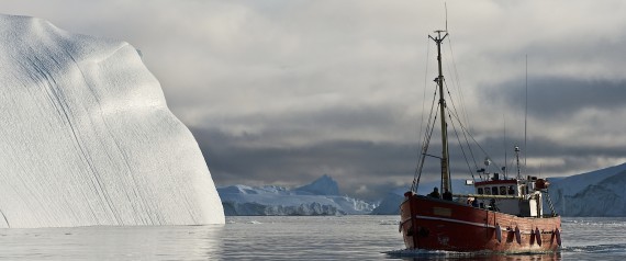
Somehow all marine-terminating glaciers across the southern half of Greenland doubled in speed simultaneously between 2000 and 2005. [Readers, this news is what caused me to begin this blog -- I had the one and only epiphany in my life when I read about this.] We didn't yet know why.
In the meantime, scientists tried defining a plausible upper limit for the contribution to sea level rise from Greenland's ice. That was at a time when surging glacier speeds -- ice flow -- was thought to be the dominant conveyer of ice loss, and would be for the foreseeable future. Well, surprise! It became clear that for six years in a row, starting in 2007, ice loss from surface meltwater runoff took over the lead position in the competition for biggest loser.  [This was something I thought privately at the time -- that this must occur eventually, but I did not imagine that it would occur so soon. I never bought into the idea that the topography was a limit on glacial outflow and thus would restrain Greenland's contribution to sea level rise.] From 2007 to 2012, nearly each summer set higher and higher melt records, owing to persistent and unforeseen weather that by 2012 would become a signature of climate change.
The competition between how much ice is lost through glacier flows into fjords versus meltwater runoff is intimately synergistic with meltwater interacting with ice flow all along the way. Increasing melt sends more water down through the ice sheet, softening the ice so it flows faster. Once at the bed the water lubricates flow. Squirting out the front of glaciers into the sea, the meltwater drives a heat exchange that undercuts glaciers, promoting calving, loss of flow resistance and faster flow. Put it this way: in Washington, DC, to know what's happening, you follow the money; in Greenland you follow the meltwater.
Put it this way: in Washington, DC, to know what's happening, you follow the money; in Greenland you follow the meltwater.
Glaciologists became oceanographers when they realized, in 2008, the trigger effect for galloping glaciers was warm pulses of subtropical waters that undermine glaciers at great depth in the sea, at the grounding lines where this warm water can invade.
Indeed, ocean warming is arguably the climate change story. The planetary energy imbalance due to the enhanced greenhouse effect is loading far more heat into the oceans than the atmosphere or land. The world is 70% ocean-covered. after all. While there were signs of a warming hiatus in air temperatures from 1998 to 2012, the ocean continued to heat up, an equivalent of four Hiroshima bombs, per second, all day, every day. The increase is continuing as we load the atmosphere with CO2.
The fundamental climate heating issue is a problem of too much of a good thing. The natural greenhouse effect -- a good thing -- keeps temperatures tolerable at night. But it has been enhanced by more than a century of people externalizing the environmental costs of stupendous economic growth, loading the atmosphere now with 42% more carbon dioxide, 240% more methane, 20% more nitrous oxide, 42% more tropospheric ozone, etc. We have far too much gaseous carbon compounds now in our atmosphere, people. The carbon pollution is, by the way, making our oceans too acidic, threatening the base of the marine food chain. Would someone step forward and deny the changing ocean chemistry? Do I digress?
We have far too much gaseous carbon compounds now in our atmosphere, people.
The key question, as I see it, is how to project what the sea level will soon be due to ice sheet melting. But this is confounded by us not really knowing what to expect. We keep being surprised by nature being more sensitive and complex. As the science develops, we see more interconnection, where multiplying feedbacks produce surprisingly fast responses.
Will there be some saving self-regulation of human-induced climate warming and its melting land ice consequences? The enormous increase of heat in our oceans, from past decades of enhanced greenhouse effect, negates any hope that negative feedbacks or even solar output will prevent a much warmer world. The few negative feedbacks we have found for ice -- like more snow as a result of a warming climate, more reflective frost, more efficient sub-glacial water transmission -- are clearly being outdone. And at the global scale, despite some negative feedbacks like more clouds, clearly we are not seeing net cooling. Feedbacks, whether positive or negative, only do their thing after the initial effect. Negative feedbacks don't reverse the perturbation.
Seemingly the biggest issue with abrupt sea level rise comes from the now-unstoppable loss of key sectors of West Antarctic ice and the discovery of more marine instability than we thought elsewhere. Like glaciers thinning rapidly in East Antarctica. Or in Greenland, where improved bedrock maps reveal a marine connection an average of 40 kilometers further inland than previously thought. Or like how new fjord underwater mapping reveals greater fjord depths, increasing the odds that deep warm ocean water can communicate with more Greenland glaciers than previously thought. Surprise, surprise, surprise.
I'd say we are in for more surprises.
If the past decade of scientific inquiry is any indication, I'd say we are in for more surprises. That notion is further supported by the fact that the climate models used for projecting future temperatures lack key processes that likely reinforce warming or the effects of warming, not regulate it.
Despite decades of progress by many clever scientists engaged with climate modeling, climate models used to inform policymakers don't yet encode key pieces of physics that have ice melting so fast. They don't incorporate thermal collapse -- ice softening due to increasing meltwater infiltration.
Climate models also don't yet incorporate increasing forced ocean convection at the ocean fronts of glaciers that forces a heat exchange between warming water and ice at the grounding lines.
Climate models don't yet include ice algae growth that darkens the bare ice surface.
Climate models don't yet prescribe background dark bare ice from outcropping dust on Greenland from the dusty last ice age.
Climate models don't include increasing wildfire delivering more light-trapping dark particles to bright snow-covered areas, yielding earlier melt onset and more intense summer melting.
As a result of some of these factors and probably some as yet unknown others, climate models have under-predicted the loss rate of snow on land by a factor of four and the loss of sea ice by a factor of two.
Climate models also don't yet sufficiently resolve extended periods of lazy north-south extended jet streams that produce the kind of sunny summers over Greenland (2007-2012 and 2015) that resulted in melting that our models didn't foresee happening until 2100.
While individual climate models come close to observations on this or that piece of the complex big picture, what ends up in global assessment reports intended to help guide policy decisions and national discussions of climate change are very conservative averages of dozens of models that don't include the latest, higher sensitivity physics.
So, alas, when it comes to ice, how fast it can go and how fast the sea will rise, if I were a betting man, I'd put my money on it going faster than forecast.

Monday, March 23, 2015

Scientists find evidence of vast “storage tanks” of water deep below the melting Greenland ice sheet that could have a major effect on sea level rise

by Tim Radford, Climate News Network, January 5, 2015

LONDON − One small mystery that surrounds Greenland’s melting ice is a little closer to being solved as scientists in the US confirm that surface meltwater can drain all the way down to fill concealed lakes under the ice.

This means that atmospheric warming can reach thousands of metres below the ice sheet − warming the glacial base and potentially increasing its rate of flow.

One group, led by geologist Michael Willis, of Cornell University, and another team led by glaciologist Ian Howat, of Ohio State University, report in two different journals on separate but related studies of Greenland’s plumbing system: what happens to meltwater.

The ice sheet of Greenland adds up to about four-fifths of the mass of the vast frozen island, and there is evidence that, as a consequence of global warming, the rate of melting has begun to accelerate.

Measurable difference

This has already begun to make a measurable difference to global sea levels, and were the entire island to shed its burden of ice – a process that would take a considerable time − then sea levels would rise by 7 metres or more.

So what exactly happens to the water that forms on the surface and collects in lakes each summer, and how much of it gets into the sea, has become an important but perplexing problem. Surface lakes are now appearing much further inland, and at higher altitudes, than recorded in the past.

Dr Howat and his colleagues report in The Cryosphere that they measured a 2-km-wide depression 70 metres deep in the icecap of southwest Greenland, which they then identified as “the first direct evidence for concentrated long-term storage and sudden release of meltwater at the bed.”

The slumped crater suggested a holding capacity of more than 30 million cubic metres of water, which had suddenly drained away.

“The fact that our lake appears to have been stable for at least several decades, and then drained in a matter of weeks – or less – after a few very hot summers, may signal a fundamental change happening to the ice sheet,” Dr Howat said.

The Cornell team worked in northeast Greenland, and in 2011 found a collapsed basin 70 metres deep. Dr Willis and colleagues report in the journal Nature that between 2011 and 2014 they watched as summer meltwater made its way down fissures in the depression and refilled a lake basin at the base of the icecap. When this in turn emptied, the researchers calculated that the flow from the subglacial lake was at a rate of 215 cubic metres per second.

“We’re seeing surface meltwater make its way to the base of the ice where it can get trapped and stored at the boundary between the bedrock beneath the ice sheet and the ice itself,” they say.

“As the lake beneath the ice fills with surface meltwater, the heat released by this trapped meltwater can soften surrounding ice, which may eventually cause an increase in ice flow.”

Glacial flow

The researchers do not yet know whether the draining water is increasing glacial flow, and nor can they be sure how many such depressions in the Greenland ice mask buried meltwater storage tanks.

But melting of glacial ice is likely to accelerate anyway, according to new research in the journal Climate Dynamics.

Earth scientist Patrick Applegate, of Penn State University, reports that computer models confirm that the more temperatures increase, the faster the ice will melt.

Were all Greenland’s ice to melt, sea levels would rise catastrophically. At least one billion people live on coasts and estuaries vulnerable to a mere one metre rise.

The Arctic is already the fastest warming place in the northern hemisphere, and the Penn State scientists wanted to see how present warming could play back into future warming. Engineers call this positive feedback.

“If we are going to do something to mitigate sea level rise, we need to do it earlier rather than later,” Dr Applegate said. “The longer we wait, the more rapidly the changes will take place and the more difficult it will be to change.”

Friday, January 16, 2015

Supra-glacial Rivers Are Draining Greenland Quickly: NASA-UCLA

from the Jet Propulsion Laboratory, NASA, January 12, 2015


A river of meltwater flowing across Greenland's ice sheet. Image credit: UCLA/Laurence C. Smith

Rivers of glacial meltwater flowing over Greenland's frozen surface may be contributing as much to global sea level rise as all other processes that drain water from the melting ice sheet combined, according to researchers at the University of California, Los Angeles, and NASA.
The new finding is published today in the journal Proceedings of the National Academy of Sciences. The research is dedicated to the memory of coauthor Alberto Behar of NASA's Jet Propulsion Laboratory, Pasadena, California, who died in a small-plane crash in Los Angeles on Jan. 9.
Eighty percent of Greenland, which is about the size of the United States west of the Rocky Mountains, is covered by ice, which has the potential to make a significant contribution to sea level rise as it melts.
Because Greenland's ice sheet is vast and difficult to study from ground level, scientists are still learning about the many processes by which its melting water reaches the ocean. This is the first study of the drainage system of rivers and streams that forms atop the ice sheet in summer.
The new paper is based on research that took place on the ice sheet itself, carried out by lead author Laurence Smith of UCLA, JPL's Behar and nine other researchers in July 2012, and on remote sensing data from the same period. The researchers traveled by helicopter to map the network of rivers and streams over about 2,000 square miles (5,600 square kilometers) of Greenland. They were especially interested in learning how much of the meltwater remained within the ice sheet and how much drained to the ocean.
Virtually all of the flowing water drains directly to the ocean through sinkholes, the researchers found.
Behar designed two types of remotely controlled boats to collect data from the surface water. One was a drone boat that measured the depth of the water and how much light it reflected, allowing the researchers to create a scale with which to calibrate the depth of the surface water from satellite images. This boat was used on lakes and slow-flowing rivers. For dangerous, swift-flowing rivers, Behar developed disposable robotic river drifters that measured streamflow velocity, depth and temperature as they swept downstream.
"The measurements we collected would not have been possible without the truly innovative instruments designed by Alberto Behar, and his steady hand during some very trying conditions in the field. The scientific outcomes of this study can be traced directly to him," said lead author Smith, professor and chair of the geography department at UCLA.
Behar, who was also a research professor at Arizona State University in Tempe, produced many other innovative technologies in a 23-year career at JPL that specialized in robotics for exploring extreme environments in our solar system. To measure ice sheets in Antarctica as well as Greenland, he also developed robotic submarines and ice rovers. Behar was an investigation scientist for instruments on NASA's Mars Curiosity rover and Mars Odyssey orbiter.
The full paper is available online at:
For more information on the research, see:
Additional information and quotes about Alberto Behar and his career can be found at:

Saturday, December 27, 2014

IceSat data confirm that Greenland's ice sheet melting has been underestimated, and it is accelerating

The most detailed study yet of the Greenland ice sheet illustrates the complex process that is causing billions of tonnes to melt every year

by Tim Radford, Climate News Network, December 27, 2014

LONDON − Greenland’s ice sheet shrank by an average of 243 billion tonnes a year between 2003 and 2009 – a rate of melting that is enough to raise the world’s sea levels by 0.68 mm per year.

In what is claimed as the first detailed study, geologist Beata Csatho, of the University of Buffalo in the US, and colleagues report in the Proceedings of the National Academy of Sciences that they used satellite and aerial data to reconstruct changes in the ice sheet at 100,000 places, and to confirm that the process of losing 277 cubic kilometres of ice a year is more complex than anyone had predicted.

The Greenland ice sheet is the second biggest body of ice on Earth − second only to Antarctica − and its role in the machinery of the northern hemisphere climate is profound.

Careful measurements

It has been closely studied for decades, but such are the conditions in the high Arctic that researchers have tended to make careful measurements of ice melt and glacier calving in fixed locations – in particular, at four glaciers − and then try to estimate what that might mean for the island as a whole.

“The great importance of our data is that, for the first time, we have a comprehensive picture of how all of Greenland’s glaciers have changed over the past decade,” Dr Csatho said.

The study looked at readings from NASA’s ice, cloud and land elevation satellite ICESat, and from aerial surveys of 242 glaciers wider than 1.5 km at their outlets, to get a more complete picture of melting, loss and – in some cases – thickening of the ice sheet as a whole.

Previous studies have focused on the four glaciers. One of them, Jakobshavn, has doubled its speed of flow since 2003, and closer studies have begun to reveal more about the dynamics of individual flows.

But the real strength of the study is that it establishes the pattern of ice melt in more detail, and suggests that climate models may not give a clear enough picture of the future of the ice cap. To put it crudely, Greenland could lose ice faster in the future than any of today’s predictions suggest.

Meanwhile, a team from the UK has been trying to work out what is happening on the surface of the ice sheet. Each summer, of course, some of the ice melts. Some of this gets to the sea, but some freezes again in the natural seasonal order of things.

But glaciology researcher Amber Leeson, of the University of Leeds, and colleagues report in Nature Climate Change that the “supraglacial” lakes that form each summer could also affect ice flow.

Their computer simulations suggest that these lakes will migrate further inland as the century wears on and the world continues to warm. Ice reflects heat, water absorbs it. So the process could trigger further melting. Some of this extra meltwater could slide or drain to the base of the glacier, lubricating its flow and accelerating the process yet again.

Thin pancake

“Our research shows that, by 2060, the area of Greenland covered by them will double,” Dr Leeson said. “When you pour pancake batter into a pan, if it rushes quickly to the edge of the pan, you end up with a thin pancake. It’s similar to what happens with ice sheets. The faster it flows, the thinner it will be.

“When the ice sheet is thinner, it is at a slightly lower elevation and at the mercy of warmer air temperatures than it would be if it were thicker, increasing the size of the melt zone around the edge of the ice sheet.”

In the last 40 years, the band in which such supraglacial lakes can form has crept 56 km inland. By 2060, the simulations now suggest, it could reach 110 km inland, doubling the area of coverage and delivering yet more meltwater to fuel further warming.

Once again, the research suggests that current models underestimate the rate of ice loss. 

Wednesday, August 8, 2012

Greenland ice sheet albedo feedback: mass balance implications, AGU 2012, Jason E. Box, Marco Tedesco, Xavier Fettweis, Dorothy K. Hall, Konrad Steffen, Julienne C. Stroeve

Greenland ice sheet albedo feedback: Mass balance implications

Jason E. Box (Byrd Polar Research Center, Scott Hall, Ohio State University, Columbus, OH, U.S.A.), Marco Tedesco (City University of New York, New York City, NY, U.S.A.), Xavier Fettweis (Department of Geography, University of Liege, Liege, Belgium), Dorothy K. Hall (NASA Goddard Space Flight Center, Greenbelt, MD, U.S.A.), Konrad Steffen (Swiss Federal Institute for Forest, Snow and Landscape Research (WSL) , Birmensdorf, Switzerland) and Julienne Christine Stroeve (National Snow and Ice Data Center, Boulder, CO, U.S.A.)

Abstract

Greenland ice sheet mass loss has accelerated responding to combined glacier discharge and surface melt water runoff increases. During summer, absorbed solar energy, modulated at the surface primarily by albedo, is the dominant factor governing surface melt variability in the ablation area. NASA MODIS data spanning 13 summers (2000–2012), indicate that mid-summer (July) ice sheet albedo declined by 0.064 from a value of 0.752 in the early 2000s. The ice sheet accordingly absorbed 100 EJ more solar energy for the month of July in 2012 than in the early 2000s. This additional energy flux during summer doubled melt rates in the ice sheet ablation area during the observation period.

Abnormally strong anticyclonic circulation, associated with a persistent summer North Atlantic Oscillation extreme 20072012, enabled 3 amplifying mechanisms to maximize the albedo feedback: (1) increased warm (south) air advection along the western ice sheet increased surface sensible heating that in turn enhanced snow grain metamorphic rates, further reducing albedo; (2) increased surface downward shortwave flux, leading to more surface heating and further albedo reduction; and (3) reduced snowfall rates sustained low albedo, maximizing surface solar heating, progressively lowering albedo over multiple years. The summer net infrared and solar radiation for the high elevation accumulation area reached positive values during this period, contributing to an abrupt melt area increase in 2012.

A number of factors make it reasonable to expect more melt episodes covering 100% of the ice sheet area in coming years: (1) the past 13 y of increasing surface air temperatures have eroded snowpack ‘cold content’, preconditioning the ice sheet for earlier melt onset, and less heat is required to bring the surface to melting. (2) Greenland temperatures, have lagged the N Hemisphere average in the 2000s, need to increase further for Greenland to be in phase with the N Hemisphere average. (3) Arctic amplification of enhanced greenhouse warming is driven by albedo feedback over sea ice, terrestrial environments, and through autumn-winter heat release from open water areas. Likely melt area increases is despite a second order negative feedback operating in the accumulation area identified statistically from more summer snowfall (brightening effect) in anomalously warm summers. Without this negative feedback, the accumulation area complete surface melting may have happened sooner than in 2012.

While it has been shown that the ice sheet dynamics can adjust rapidly to ice flow perturbations, a negative feedback responsivity, the mass imbalance of the ice sheet in the coming decades is likely to be increasingly negative because of the positive feedback from surface albedo with air temperature. Surface melting may therefore increasingly dominate ice sheet mass loss, as glaciers retreat from a marine termini and the area of low albedo expands over the gradually sloping ice sheet. The albedo feedback ensures an increasing solar energy absorption. What could shut the positive feedback down would be a combination of an anomalously cold winter and anomalously thick snowpack. This scenario is possible given the cooling effect of a major N Hemisphere volcanic eruption or some other event to reduce surface heating.

http://bprc.osu.edu/wiki/Greenland_Ice_Albedo_Monitoring

http://www.meltfactor.org/blog/?p=710