Blog Archive

Showing posts with label Polar jet stream. Show all posts

Thursday, April 14, 2016

Warm, Southerly Winds Gust to Hurricane Force Over Greenland in Staggering Early Season Heatwave — Temperatures Now Hitting up to 41 Degrees (F) Above Average at Summit

by Robert Schribbler, April 13, 2016

The wavy, crazy Jet Stream.
Over the past few years, it’s become more and more clear that a human-forced heating of the Arctic has basically driven the Jet Stream mad. Big loops, omega blocks, and huge ridges and troughs have all become a feature of the new climate we’re experiencing. Related to these features have been a number of superstorms, severe droughts, ocean hot and cold pools, and extreme rainfall events.
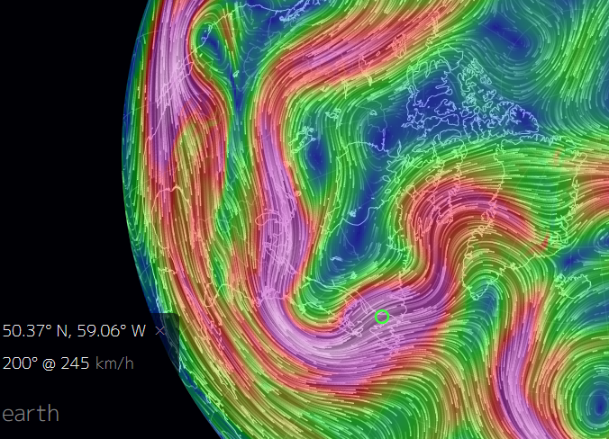
Trough US East Coast Ridge Greenland
The Jet Stream once again mangled. A strong trough shoved cool air over the US East Coast this weekend as a facing ridge prepared to hurl a bulge of extreme warmth up and over Greenland on Monday. Image source: Earth Nullschool.
As we have  seen with Sandy, the Pacific Hot Blob, the UK floods, The California Drought, the record Alaska and Canadian Wildfire Seasons of 2015, the Russian Heatwave and Fires of 2011, the Pakistan Floods of 2011, and so, so many more extreme weather events, these new climate features present a risk of generating extraordinary or never before seen weather. Intense storms, extreme winds, and extreme cold flashes and heatwaves can all be generated as the result of such mangled weather patterns. And for much of the North Atlantic this past weekend, such abnormal conditions dominated. The US East Coast experienced a freak cold flash, the UK was pummeled by yet one more unseasonable gale, but perhaps worst of all — a head of extraordinarily warm air roared northward, riding upon gale to hurricane force winds, setting sights on Greenland.
Cool Flash for Eastern US, Extreme Heat for Greenland
This past weekend, the US weather news was all awash with comments on Winter-like conditions in April for the Northeast and Mid-Atlantic US as a deep trough tore down from the Canadian Archipelago and Hudson Bay. The trough brought with it snow flurries, freeze warnings, and rather cold conditions for April to this region of the US. Temperatures ranged from 10-20 degrees (F) below average for this area. But compared to what was setting up to happen in the ridge zone over the Atlantic, the East Coast cool spell was quite mild considering the relative extreme heat readying for a Greenland invasion.
The warm wind pulse began in the North Atlantic in a tropical region near 26 North, 55 West. This warm air flooded in train over thousands of miles of open ocean. Running northward, it roared along the back of a high pressure system centered over the Mid Atlantic Ridge and in front of two strong lows — one centered near Newfoundland and a second over southwestern Baffin Bay.
In places, the pressure gradient between the lows and highs was so tightly packed that the northward flowing airs hit hurricane force. Off the southwest tip of Greenland, winds consistently achieved hurricane force gusts. And these winds flowed on northward, bringing with them a surge of above freezing temperatures to much of Baffin Bay and a large section of Western Greenland.
Extreme Greenland Heatwave
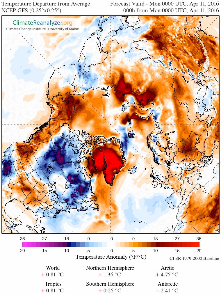
Extreme Arctic heat strikes Greenland on April 11, 2016. There readings for a large area hit a range 36 degrees Fahrenheit or more above average for a large region over Baffin Bay and Greenland. This extreme pulse of unseasonable warm air contributed to overall temperature departures of +4.75 C (8.55 F) above average for the Arctic. A very high departure for this region of the world at this time of year and an extension to a period of record Arctic warmth in 2016. Image source: Climate Reanalyzer.
Further south, Nuuk was experiencing 45 F readings (or about 20 F above average) coordinate with heavy rain and strong southerly winds. Yet further south, in Kangerlussuaq near the southwest coast of Greenland, temperatures spiked to 61 F — or 36 F above the average April 11 reading of 25 F.
Perhaps more remarkable and disturbing were the predicted extreme readings at Summit Greenland — expected to hit 21 degrees Fahrenheit on Monday or about 41 degrees (F) above a typical daily high of -20 (F) for this time of year. It’s worth noting that in July average high temperatures for Summit Greenland usually range near 12 degrees (F). So current expected highs for April 11, 2016, are nearly 10 degrees warmer than a normal July day. By comparison, if such an extreme high temperature departure were to have occurred in my hometown of Gaithersburg, MD, on the same date (April 11th), readings would have exceeded a remarkable 106 degrees Fahrenheit.
Year of Record Arctic Warmth Continues
The recent warm, wet wind outbreak over Greenland is but one more odd event in a year of extreme warmth for the Arctic. Warm wind invasions over the North Atlantic, Barents, Baffin Bay, Greenland Sea, Western Europe, Alaska, Western Canada, the Barents, and sections of Central Asia have been a persistent feature throughout both Winter and Spring. Meanwhile, consistent temperature spikes to near freezing or above freezing over the Arctic Ocean and related waters have contributed to Arctic sea ice hitting new seasonal lows.
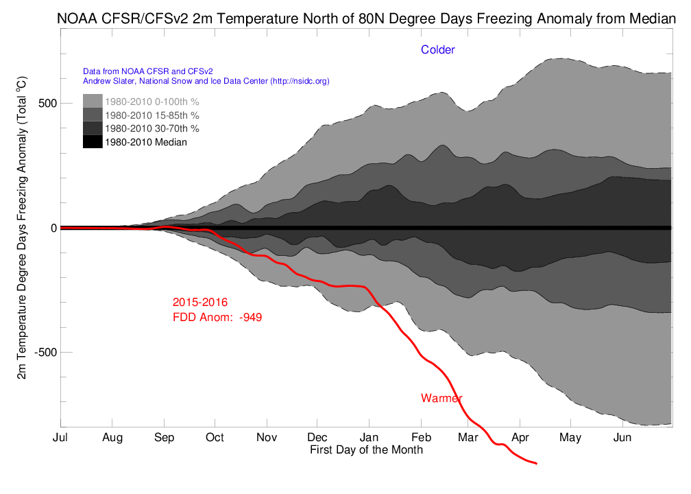
Freezing Degree Days NOAA
Arctic heat has been literally off-the charts for the region above 80 degrees North during 2016. This area has now experienced nearly 1,000 fewer freezing degree days than during a typical year of the already warmer than normal 1980-2010 period. Extreme Arctic warmth of this kind has negative impacts both to the health of Arctic sea ice and to that of the various glacier systems in Greenland, Svalbard and Northern Canada. Image source:NOAA/CFSv2/CFSR.
Overall, the Arctic has experienced unprecedented warmth for 2016. In reference to this fact, NOAA measures recording freezing degree days indicate that both the Arctic and the High Arctic above 80 degrees North Latitude are experiencing their warmest year ever recorded. These new extreme high temperatures are achieving an extraordinary departure above previous temperature measures and are a feature of the highest anomalies occurring over any portion of a record warm world. In other words, if you were to look for the region of the world that’s being hit hardest by a human-forced warming spurred on by rampant fossil fuel burning, the Arctic would light up like a fireworks display on the 4th of July.
Tropical heat, in the form of a record El Nino generated warmth, has tended to transfer pole-ward in the Northern Hemisphere during 2016 due to various weaknesses in the Jet Stream. A primary region for this transfer has occurred over the North Atlantic and Europe with secondary transfer zones over the Eastern Pacific, Western North America, and over a shifting zone throughout Northern Asia.
An extraordinary polar amplification of this kind — one that includes Equator-to-Pole heat transfers — risks hitting or increasing the intensity of a number of harmful climate tipping points. These include the amplifying feedbacks of increasing rates of sea ice melt and Arctic carbon store response. In addition, extreme warmth over Greenland risks further glacial destabilization, increasing rates of sea level rise, and increasing weather instability in the North Atlantic.

Friday, February 26, 2016

Arctic warming: Rapidly increasing temperatures are 'possibly catastrophic' for planet, climate scientist Peter Gleick warns

Dr Peter Gleick said there is a growing body of 'pretty scary' evidence that higher temperatures are driving the creation of dangerous storms in parts of the Northern Hemisphere


web-arctic-warming-get.jpg

The area covered by sea ice has been noticeably below any of the last 30 years Getty

by Ian Johnston, The Independent, February 25, 2016


The rapidly warming Arctic could have a “catastrophic” effect on the planet’s climate, a leading scientist has warned.
Dr Peter Gleick, president of the Pacific Institute in California, said there was a growing body of “pretty scary” evidence that higher temperatures in the Arctic were driving the creation of dangerous storms in parts of the Northern Hemisphere.
According to a graph on the US National Snow and Ice Data Centre’s website, there were 14.2 million km squared of sea ice on 24 February 2016. On an average year over the last three decades, it would take until about 29 April for there to be as little sea ice as temperatures warm in the spring.
Since about 10 February, the area covered by sea ice has been noticeably below any of the last 30 years as the Arctic has experienced record-breaking temperatures of about 4C higher than the 1951-1980 average for the region.
Dr Gleick posted the sea ice graph on Twitter with the message: “What is happening in the Arctic now is unprecedented and possibly catastrophic.”
And, in emails to The Independent, he explained: “The current trend is below any previous year. What is alarming is how far below any previous ice extent the current data are [and] how early it is for there to be this little ice.
“It is certainly possible that the ice extent will track back up if cold enough weather returns, for long enough. It is just very unlikely.”
While such changes will have a harmful effect on polar bears, walruses and other elements of the Arctic ecosystem, Dr Gleick said the potential for catastrophe was from “the global implications of those changes.”
“The evidence is very clear that rapid and unprecedented changes are happening in the Arctic,” he wrote.
“What is much less clear is the complex consequences. We are, effectively, conducting a global experiment on the only planet we have. The interconnections with weather patterns, sea-level, and more are real.
“And while there remains uncertainty about the ultimate consequences, there is a good and growing body of research that is pretty scary, and pretty much no evidence that the possible impacts will be good, unless you are a global shipping company hoping to save some money by opening up routes in the Arctic or an oil/gas company hoping to find new cheap fossil fuels.”
Among the “scary” possibly consequences is that the warming Arctic is altering weather systems for much of the Northern Hemisphere – and not in a good way.
“Changes in ice extent and volume may all be reflected in weather patterns in mid-latitudes. In 2015, a phenomenon called the polar vortex and unusual patterns of jet stream flow brought record-breaking hot and cold weather to different parts of the US,” Dr Gleick wrote.
“Massive storms, sometimes called ‘bomb cyclones’, are created when warm air from the Atlantic and cold air from the Arctic combine. Just this season, massive flooding associated with one of these storms struck the United Kingdom producing record rainfall.
“There may be connections between out-of-season strong tornadoes in the central US and these new storm patterns. The central US was hit by unusual numbers of tornadoes in December 2015 causing billions in damage and many deaths.
“Part of the science on this suggests that as the Arctic warms faster, the difference in temperature between the mid-latitudes and the Arctic region decreases. This, in turn, affects storm tracks and the location and strength of the jet stream.”
The reduced amount of white ice also means less energy from the Sun is reflected back into space. Water, which is darker than ice, absorbs more energy and increases the rate of warming.
Dr Gleick said one of the reasons he was interested in Arctic sea ice was the ongoing drought in California.
“We've had four years of severe drought and hoped that the current El Nino [weather system], the strongest on record, would bring relief in the form of strong precipitation,” he wrote.
“It hasn't so far, and there are only about six to eight more weeks in our rainy season. One reason appears to be that storm tracks have gone far to the north because, possibly, of these very changes in the Arctic and atmospheric circulation patterns.
“I'm afraid we're in for a fifth year of drought.”

Saturday, June 13, 2015

Rapid Arctic ice loss linked to extreme weather changes in Europe and US

Arctic warming appears to be the prime reason behind fluctuations in the polar jet stream that is causing unusual weather, study says 

by John Vidal, The Guardian, June 1, 2015

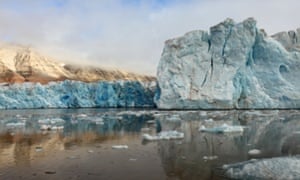
BEE9T7 Arctic Glacier Reflected and Melting in Svalbard KongsFjordenGlacierArcticIceBlueSvalbardPolarClimateArcticNorwaySvalbardSpitsbergenNyAlesundNatureLandscapeSceneryPanoramaViewScenicFjordBarentsSeaOceanNordicScandinavianMountainsPolarSummerCalmPlacidPeacefulClimateChangeGlacierMeltingIceEnvironmentalismReflectionDramaticSailingGlobalWarmingKongsfjordenFloat

 Arctic is warming faster than elsewhere, triggering changes in the jet stream which will create more extreme weather in western Europe and North America, researchers say. Photograph: Alamy
The string of massive snowstorms and bone-chilling cold on the US east coast, as well as flooding in Britain and record temperatures in Europe, are linked to rapid ice loss in the Arctic, new research appears to confirm.
While the rapidly-thawing Arctic cannot be held responsible for specific weather events like the “snowmageddon” in 2009, Hurricane Sandy, or European heatwaves, researchers at Rutgers university said it appears to be a prime reason why the polar jet stream – a ribbon of winds that encircles the globe – gets ‘stuck’ with increasing frequency.
Western Europe and large parts of North America will experience more extreme weather because of “Arctic amplification” - the enhanced sensitivity of high latitudes to global warming, the team suggested in a paper published in the journal Philosophical Transactions of the Royal Society A
“We are seeing these extremes because the Arctic is warming faster than elsewhere. The whole lower atmosphere is heating up but the sea ice is the most observable. This is having this effect on the jet stream, making it extend further south and stay longer,” said co-author Jennifer Francis.
“The jet stream creates weather of all sorts and where you are in relation to it dictates wether it is hot or cold. When we have a ridge, or a big bulge, in the the jet stream, it makes it extend further and stay longer. When that ridge is stronger it tends to be more persistent,” she said.
Deep troughs in the jet stream have been seen regularly in the past few years affecting the east coast of the US, western Europe and central Asia. These have brought prolonged, unusually hot weather to some places, and extended cold or record snowfall to others.
“We are seeing extended periods of extreme weather because when the temperature difference between polar and mid northern latitudes gets smaller [because of global warming] this has the effect of weakening the jet stream , allowing it to be deflects more easily and to meander more. It’s a combination of natural conditions being intensified and global warming,” said Professor Francis.
The authors expect that eventually it will be possible to predict accurately which types of extreme events will be more likely to occur in certain areas but because Arctic amplification has emerged only in the past 20 years it is a challenge to pin down exactly how it affects weather patterns. 
But the impacts could be substantial, they warn. “This new manifestation of of global warming ... may have substantial societal impact as more frequent extreme weather events in mid latitudes will affect billions of people directly through damage to property and infrastructure and indirectly through farming and water supplies,” the authors wrote.
The study builds on other research which shows how the changing Arctic may be affecting weather in mid-latitudes. According to some, a slower jet stream takes a more meandering path as it encircles the northern hemisphere. Other studies have linked ice loss in the Barents and Kara seas to the north of Russia with extremely cold winters in central Asia.
According to the US Snow and Ice data centre, Arctic sea ice extent last month averaged 5.4 million square miles), the second lowest April ice extent in the satellite record. It is 313,000 sq m) below the 1981 to 2010 long-term average of 6 million sq m) and 31,000 sq m) above the previous record low for the month observed in 2007.

Sunday, April 5, 2015

Warming Arctic blamed for worsening summer heatwaves

Russia's 2010 heatwave - a harbinger of even more torrid times? <i>(Image: ARTYOM KOROTAYEV/AFP/Getty)</i>
Russia's 2010 heatwave  a harbinger of even more torrid times? (Image: ARTYOM KOROTAYEV/AFP/Getty)

by Fred Pearce, NewScientist, March 12, 2015

It seems our weather is getting slower – and hotter. Arctic warming appears to be aggravating summer heatwaves across Europe and North America, by putting the brakes on atmospheric circulation in mid-latitudes.
The team that uncovered this Arctic effect says it caused the Russian heatwave of 2010, which lasted six weeks, killing crops and causing massive forest fires; the west European scorcher of 2003 that killed an estimated 70,000 people; and possibly the record US heatwave of 2012, which decimated corn crops.
Dim Coumou and colleagues at the Potsdam Institute for Climate Impact Research in Germany studied atmospheric circulation in the Northern Hemisphere from 1979 to 2013. They found longer and more frequent hot spells in mid-latitudes that, they say, are likely to have been triggered by a reduction in the temperature difference between the Arctic, which is warming quickly, and mid-latitudes, where average warming is slower.
The Arctic has in fact warmed twice as fast as the rest of the globe, because of the melting of the ice replaces a reflective surface with dark ocean that absorbs much more solar energy.
Climatologists believe that this temperature difference drives the general west-to-east movement of mid-latitude weather systems, such as the depressions that bring storms and the high-pressure systems that bring hot dry weather in summer and intense cold in winter. A smaller temperature difference slows these systems down, so their associated weather persists for longer.

Bogged down for weeks

Coumou's team found that the frequency of stalled weather systems in summer has doubled since the onset of rapid Arctic warming around 2000. In many cases, they stop moving for weeks at a time. That can mean long spells of hot weather that dry out soils, kill crops, empty rivers, trigger forest fires – and strain the body, with consequences for our health. So even though average weather is not changing much at mid-latitudes, the incidence of heatwaves is increasing fast.
Until recently, says Coumou, researchers had presumed that impact of the Arctic warming on mid-latitudes was greatest in autumn and winter, when heat flows from the oceans into the cooled atmosphere.
The resulting stalled weather systems have been blamed  alongside the changing polar vortex  for the present long cold winter in the eastern US and the one immediately before this. But Coumou says that the summer effects are just as strong.
Jennifer Francis of Rutgers University, New Jersey, says the findings support her hypothesis that Arctic warming is slowing the jet stream, a high-altitude wind that drives atmospheric circulation at ground level in mid-latitudes.
"Coumou and his colleagues are looking at the individual weather systems that ride along the flow of the jet. And they find that as the Arctic warms, the weather systems stall, leading to more persistent heatwaves," she says. "In the case of heatwaves, there is less surface wind to stir up and distribute heat from a scorching sun beating down on dry soil."
With the Arctic melt set to continue, the long-range forecast is looks set to feature more heatwaves and more drought.
http://www.newscientist.com/article/dn27150-warming-arctic-blamed-for-worsening-summer-heatwaves.html

Monday, August 18, 2014

Scientists probe poorly understood linkage between melting Arctic and extreme weather

by Christa Marshall, E&E reporter, Climate Wire, August 18, 2014


Snowmageddon in Washington, D.C. Extreme floods in the United Kingdom last winter. A Texas heat wave two years ago.
For scientists, they all may be a byproduct of a warming Arctic. Or they might not, as much of the research on causation is still in early stages.
A new review article, released yesterday in Nature Geoscience, offers one additional theory about the link between the Arctic and extreme weather in mid-latitudes, pointing to a possible connection between snow in Siberia and unusual events in much of the United States, Europe and East Asia. But ultimately, the synthesis paper reports that much of the science remains uncertain about the link, as there is contradictory evidence for all of the main theories.
"The discussion on the topic until now has been 'he said, she said' where the ideas presented have been of individual scientists and have covered the spectrum of all possible opinions. This is the first that a group of leading experts with varying opinions all on the same paper and is the most authoritative consensus on the subject," said Judah Cohen, a scientist at Atmospheric and Environmental Research Inc. and lead author of the review article, which included scientists from six universities, research institutes and NOAA.
Basic statistics initially appear to reveal a link between Arctic changes and weather elsewhere. Since the late 1970s, Arctic September sea ice has declined at a rate of 12.4% per decade. The Arctic region has warmed about twice the global average, a phenomenon known as Arctic amplification. At the same time, there has been a trend toward many types of extreme weather in mid-latitudes.
The amount of precipitation on very wet days has increased since the late 1990s in mid-latitudes, for instance, and the percentage of warm days exceeding the 90th percentile has increased from 10% before 1980 to 16% now, the paper notes.

Dynamics that conflict with climate models

The scientists focused on winter weather extremes, as that season has "not always followed the warming script," Cohen said. "While global warming theory is consistent with record warm temperatures and more intense precipitation events, it does not directly explain cold extremes," the paper says. For example, the number of days continuously below freezing has increased in mid-latitudes, a dynamic that is not consistent with the projections of climate models.
The scientists examined dozens of papers and categorized them into three main theories about a possible link between the Arctic and different types of mid-latitude extreme weather. One suggests that warming spurs extra snow over Eurasia, as well as sea ice loss, which in turn shifts storm tracks south.
A second -- and highly discussed -- hypothesis is that a warming Arctic causes the jet stream to weaken and meander more in a North-South direction. Weather systems embedded in the jet stream then move more slowly, allowing events such as lengthy heat waves.
"The temperature difference between the Arctic and mid-latitudes is lessening. This is important because the west to east winds of the jet stream are driven by that temperature difference," said Rutgers University scientist Jennifer Francis, the lead proponent of the theory, in congressional testimony last year. Francis -- one of the co-authors of the new review article -- argued that the lessening temperature differential drives the North-South movement of air.
The third concept -- relevant for winter extremes -- is that the loss of sea ice in the Barents and Kara Seas in fall and winter helps create atmospheric "waves" that transfer energy from the low to the high atmosphere, that in turn alters the deep pressure known as the polar vortex, helping send Arctic blasts south.
The researchers added a fourth theory, that this "wave" phenomena may be boosted by increased snow cover over Siberia in October as well, in conjunction with the loss of sea ice. Previously, sea ice and snow cover on land largely had been talked about separately with the wave theory. "They can amplify the same result," Cohen said.

Four conflicting theories

Each of the theories has drawbacks, according to the paper. While most models show that warming leads to a southward movement of storm tracks, others do not, Cohen said.
The jet stream theory is probably the most controversial, as it is the least studied of the three, even as it is the most discussed, he said. The concept was the focal point of a National Academy of Sciences report in April synthesizing input from an earlier scientific meeting on the plausibility of the Arctic-weather link.
While the jet stream theory is plausible, there are also forces working against it "that may be canceling each other out," Cohen said. Arctic warming is occurring more at the surface and not at jet stream latitudes, he said. The tropics are more where warming is occurring at high latitudes, so it's not clear how much that is countering any influence on the jet stream from the north, he said.
For all three theories, it also is unclear how much Arctic amplification may be caused by mid-latitude weather in the first place via transfer of heat, as opposed to the reverse. Cohen called for more Arctic monitoring stations of everything from humidity to temperature to get a firmer grasp of what's happening.
Earlier this year, five climate scientists wrote a letter in Science during then-frigid temperatures in the eastern United States, urging the public to not make immediate conclusions about a climate change connection to the extreme weather. "The research linking summertime Arctic sea ice with wintertime climate over temperate latitudes deserves a fair hearing. But to make it the centerpiece of the public discourse on global warming is inappropriate and a distraction," the scientists wrote.
While the new analysis does not get any closer to certainty on any of the theories, it was important to get many of the lead scientists studying the topic in consensus on one paper, to provide an information baseline, Cohen said.
"I think the fact that anything was written is an accomplishment," he said.

Monday, August 11, 2014

Arctic warming causing quasi-stationary blocking patterns and extreme weather becoming more common

Rise in blocking-patterns – hot or wet weather remaining stuck over regions for weeks – causing frequent heatwaves or floods

by Damian Carrington, The Guardian, August 11, 2014


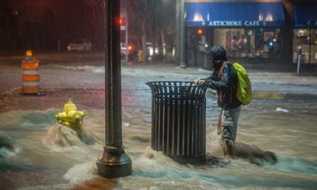
A pedestrian hangs on to a trash can along Central Avenue as rainwater flows towards downtown Albuquerque, N.M.,  August 1, 2014.  Heavy rains late Friday night caused the flash flooding and road closures in parts of downtown and in other areas.
A man hangs on to a trash can as rainwater gushes towards Albuquerque in New Mexico, US. Heavy rains caused flash flooding and road closures in the city earlier this month. Photograph: Roberto E. Rosales/AP
Extreme weather like the drought currently scorching the western US and the devastating floods in Pakistan in 2010 is becoming much more common, according to new scientific research.
The work shows so-called “blocking patterns,” where hot or wet weather remains stuck over a region for weeks causing heatwaves or floods, have more than doubled in summers over the last decade. The new study may also demonstrate a link between the UK’s recent flood-drenched winter and climate change.
Climate scientists in Germany noticed that since 2000 there have been an “exceptional number of summer weather extremes, some causing massive damage to society.” So they examined the huge meanders in the high-level jet stream winds that dominate the weather at mid-latitudes, by analysing 35 years of wind data amassed from satellites, ships, weather stations and meteorological balloons. They found that blocking patterns, which occur when these meanders slow down, have happened far more frequently.
“Since 2000, we have seen a cluster of these events. When these high-altitude waves become quasi-stationary, then we see more extreme weather at the surface,” said Dr Dim Coumou, at the Potsdam Institute for Climate Impact Research. “It is especially noticeable for heat extremes.” The intense heatwaves in Russia in 2010, which saw 50,000 people die and the wheat harvest hit hard, and in western Europe in 2003, which saw 30,000 deaths, were both the result of blocking patterns. The Intergovernmental Panel on Climate Change concluded in 2011 that extreme weather would become more common as global warming heats the planet, causing both heatwaves and increasingly severe rain storms.


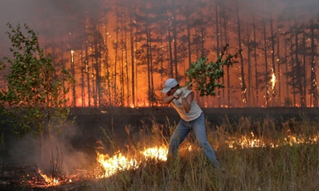
A Russian man tries to stop fire near village Dolginino on August 4, 2010. Russia's worst heatwave for decades shows no sign of relenting, officials warned as firefighters battled hundreds of wildfires in a national disaster that has claimed at least 40 lives.
In 2010, heatwaves caused hundreds of wildfires across Russia. Above, a man tries to stop a fire near Dolginino village. Photograph: Artyom Korotayev/AFP/Getty Images

The rise in blocking patterns correlates closely with the extra heating being delivered to the Arctic by climate change, according to the research which is published in the journal Proceedings of the National Academies of Science (PNAS). Coumou and his colleagues argue there are good physical reasons to think there is a causal link, because the jet streams are driven by the difference in temperature between the poles and the equator. As the Arctic is warming more quickly than lower latitudes, that temperature difference is declining, providing less energy for the jet stream and its meanders, which are called Rossby waves.
Prof Ted Shepherd, a climate scientist at the University of Reading, UK, but not involved in the work, said the link between blocking patterns and extreme weather was very well established. He added that the increasing frequency shown in the new work indicated climate change could bring rapid and dramatic changes to weather, on top of a gradual heating of the planet. “Circulation changes can have much more non-linear effects. They may do nothing for a while, then there might be some kind of regime change.”
Shepherd said linking the rise in blocking events to Arctic warming remained “a bit speculative” at this stage, in particular because the difference between temperatures at the poles and equator is most pronounced in winter, not summer. But he noted that the succession of storms that caused England’s wettest winter in 250 years was a “very good example” of blocking patterns causing extreme weather during the coldest season. 
“The jet stream was stuck in one position for a long period, so a whole series of storms passed over England,” he said.


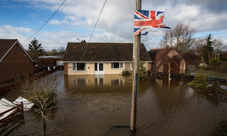
Flooding in the town of Northmoor Green (Moorland), where almost all residents have now been evacuated, Somerset, 10 February 2014
Flooding in Northmoor Green (Moorland) in Somerset, UK, in February this year. Photograph: David Levene for The Guardian

Coumou acknowledges his study shows a correlation – not causation – between more frequent summer blocking patterns and Arctic warming. “To show causality, computer modelling studies are needed, but it is questionable how well current climate models can capture these effects,” he said.
Prof Tim Palmer, at the University of Oxford, wrote in a PNAS article in 2013 that understanding changes to blocking patterns may well be the key to understanding changes in extreme weather, and therefore to understanding the worst impacts of climate change on society. But he said climate models might have to run down to scales of 1 km to do so. “Currently, national climate institutes do not have the high-performance computing capability to simulate climate with 20-km resolution, let alone 1 km,” he wrote. “[I] look forward to the day when governments make the same investment in climate prediction as they have made in finding the Higgs boson.”

Thursday, July 17, 2014

Weather weirding: Is global warming causing extreme weather via jet stream waves?

 A new study investigates how changes to atmospheric winds are making weather more extreme

by John Abraham, "Climate Consensus - The 97%," The Guardian, July 17, 2014


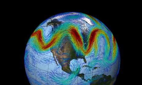
The jet stream that circles Earth's north pole travels west to east. But when the jet stream interacts with a Rossby wave, as shown here, the winds can wander far north and south, bringing frigid air to normally mild southern states.
The jet stream that circles Earth's north pole travels west to east. But when the jet stream interacts with a Rossby wave, as shown here, the winds can wander far north and south, bringing frigid air to normally mild southern states. Credit: NASA Goddard Space Flight Center
As I sit here in a northern part of the United States (Minnesota), a rare summer arctic blast barrels down from Canada on what otherwise is one of the warmest days of the year. Global warming? I could use some global warming today, people are saying.
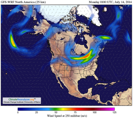
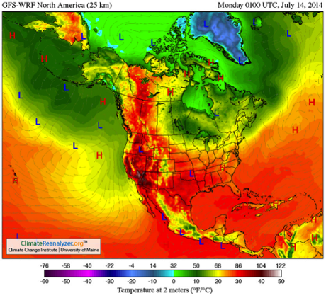
Not only is this a teachable moment, but it coincides with a major new study on climate connections. First, let’s see the current jet stream. It is wildly undulating, first swinging up into northern Canada before curving back and plunging into the central United States. 
Typically, the jet stream represents a separation between cold arctic air and warmer southern air. If you are north of the jet stream, temperatures are cold whereas south of the jet stream it's more likely to be warm.

Image obtained using Climate Reanalyzer (http://cci-reanalyzer.org), Climate Change Institute, University of Maine, USA.

With this in mind, and the jet stream shown, you can almost predict the temperature pattern in the next image. The match is incredible and it is clear that my Minnesota cold-blast is more than balanced out by near 90°F temperatures in northern Canada. With all of this, I want to talk about a new study that looks at these fluctuations on a longer term.

Image obtained using Climate Reanalyzer (http://cci-reanalyzer.org), Climate Change Institute, University of Maine, USA.

Very recently, a paper Amplified mid-latitude planetary waves favor particular regional weather extremes was published in the journal Nature Climate Change. The authors, James Screen and Ian Simmonds, investigated the role that changes to upper level winds in the atmosphere have on the occurrence of extreme weather. What they found was very interesting.
People who follow this site and the climate literature no doubt are aware that a hotly debated topic has arisen in recent years. I have written about studies that have linked loss of Arctic ice and warming of the Arctic region to more severe undulations in the jet stream. That research is still in its infancy and consequently, very exciting. While the idea that global warming increases jet stream undulations have been challenged by others, it is clear that some recent observations support the hypothesis.
The latest study is related to this topic but still unique. The authors don’t ask the question “are humans changing the jet stream patterns?” Instead, they ask, “how do undulations in the jet stream affect weather?” To be fully accurate, the study isn’t just about jet streams, it really deals with mid-latitude planetary waves but for this article, I will use the term “jet stream” as a surrogate for simplicity.
The authors went back into our weather records (1979–2012) and found the 40 months with the most extreme weather (most extreme precipitation and most extreme temperatures). They then evaluated how “wavy” the jet stream was during those extreme months. They found that:
months of extreme weather over mid-latitudes are commonly accompanied by significantly amplified quasi-stationary mid-tropospheric planetary waves. Conversely, months of near average weather over mid-latitudes are often accompanied by significantly attenuated waves.
In common parlance, this means that when the jet stream undulates and travels very slowly, we see more extreme weather. Conversely, when the jet stream travels in a straighter path, the weather is less extreme.
This association itself is not new but it brings the connection of large-scale climatic variations and our local weather to the fore of attention. Perhaps more important, however, are the follow-on observations from the authors. In particular, they report:
Depending on geographical region, certain types of extreme weather (for example hot, cold, wet, dry) are more strongly related to wave amplitude changes than others. The findings suggest that amplification of quasi-stationary waves preferentially increases the probabilities of heat waves in western North America and Central Asia, cold outbreaks in eastern North America, droughts in central North America, Europe, and central Asia, and wet spells in western Asia.
Dr. James Screen, a Research Fellow at the University of Exeter and lead author of the study told me, 
The impacts of large and slow moving atmospheric waves are different in different places. In some places amplified waves increase the chance of unusually hot conditions, and in others the risk of cold, wet or dry conditions.
To my knowledge, previous investigations have not elucidated the geographical locations of extreme weather nor have they identified the location-dependent weather extremes. It will be interesting to watch present and future weather to determine if these relationships between waves and weather continue. 
A note of caution however, we must be mindful that there are other weather factors at play which are superimposed on those discussed in the article. For instance, changes from El Niño to La Niña in the Pacific and long-term variability of sea surface temperatures in the Atlantic are also known to impact our weather extremes. Separating these multiple factors will take skill.

Tuesday, February 25, 2014

Alun Hubbard on the 50- to 150-year storms hitting Aberystwyth, Wales

by Peter Sinclair, "This Is Not Cool," Yale Forum, February 25, 2014

I first interviewed Dr. Alun Hubbard on the edge of the Watson River in Kangerlussuaq, Greenland last summer.  His vivid language and lucid storytelling made that video on of the most popular in the Yale Series (see below).

Both Dr. Hubbard, and my Dark Snow Project cohort, Sara Penrhyn Jones, live in the tiny village of Aberystwyth, on the coast of Wales, and teach at the local university. I skyped with Alun a week or so ago in the midst of the storms hammering the area. Shortly after that he wrote me to explain that his roof had just blown off in hurricane force winds.


Sara was kind enough to shoot some video of the surf pounding the area, although not at the height of the storms, and she caught up with Hubbard long enough for a colorful and well-informed take on a seminal weather event.

I’ll cut together some of Alun's further remarks that did not make this video in the next day or so – see Hubbard’s Greenland interview below: