March 30, 2009
NSIDC: 2009 annual maximum Arctic sea ice extent confirmed
Sign up for the  Arctic Sea Ice News RSS feed for automatic notification of analysis updates. Updates are also available via Twitter.
Arctic sea ice extent reached its maximum extent for the year, marking the beginning of the melt season. This year’s maximum was the fifth lowest in the satellite record. NSIDC will release a more detailed analysis of winter sea ice conditions during the second week of April.
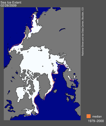
 Figure 1. Arctic sea ice extent for February 28, 2009, the date of the annual maximum, was 15.14 million square kilometers (5.85 million square miles). The orange line shows the 1979 to 2000 median extent for that day. The black cross indicates the geographic North Pole. Sea Ice Index data. About the data. —Credit: National Snow and Ice Data Center
High-resolution image
Overview of conditions
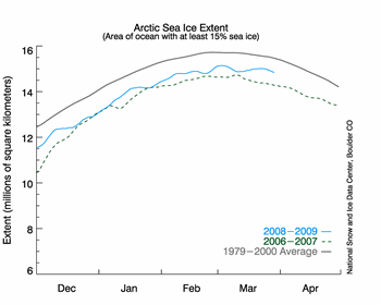
On February 28, Arctic sea ice reached its maximum extent for the year, at 15.14 million square kilometers (5.85 million square miles). The maximum extent was 720,000 square kilometers (278,000 square miles) below the 1979 to 2000 average of 15.86 million square kilometers (6.12 million square miles), making it the fifth-lowest maximum extent in the satellite record. The six lowest maximum extents since 1979 have all occurred in the last six years (2004 to 2009).
 Figure 2. The graph above shows daily sea ice extent. The solid blue line indicates 2008 to 2009; the dashed green line shows 2006 to 2007 (the record-low summer minimum occurred in 2007); and the solid gray line indicates average extent from 1979 to 2000. Sea Ice Index data. —Credit: National Snow and Ice Data Center
High-resolution image
Conditions in context
In the beginning of March, ice extent began to decline, and it appeared that Arctic sea ice had reached its maximum extent. However, in the second week of March the ice edge began to expand again. Ice extent grew through much of the month of March, but it did not expand to the level seen on February 28.
Such ups and downs in Arctic sea ice extent are not unusual near the annual maximum. As discussed in our March 3 post, the ice edge at this time of year consists of thin ice that is sensitive to temperature changes, and easily redistributed by storm winds.
Link to NSIDC page: http://nsidc.org/arcticseaicenews/index.html


No comments:
Post a Comment