There are many highly trained, physically fit people in the US military that have an awful lot of down time. These people need to be trained in fighting fires, and the extremely sensitive IR technology on aircraft and satellites owned by the military needs to be utilized for identifying and locating hot spots where fires start. Then water bombers can extinguish the fires or, for larger events, heavy lift aircraft can drop soldiers and their firefighting equipment to fires within minutes of them starting to rapidly extinguish them. This would save the US many billions of dollars in economic damages from these massive fires, and would help to transition the military to fighting climate change instead of imaginary enemies. The 300 fires burning millions of square kilometers in Alaska at the moment would not have occurred…
UPDATE1: from an email communication with Paul Beckwith:
We have to remember that the massive fires that are occurring in Alaska and northern Canada (Alberta and Saskatchewan) are getting out of control. Not only do the combustion products of ash and CO2 affect climate in the short term, especially if the ash is carried into the Arctic, but they leave vast areas of blackened regions that greatly lower the albedo.
In the case of Alaska, most of those fires are burning over permafrost. Severe fires like these burn down into the upper soil layers and replace the insulating properties that keep the permafrost cold with black surfaces that cause accelerated heating of the permafrost. Also, if it rains strongly even many months after a massive fire then the water does not run off as it would with frozen permafrost but pools and goes into the ground, and results in a rapid acceleration of CH4 emissions.
by Robert Schribbler, his blog, June 29, 2015
All throughout the mainstream media last week we heard the same myopic litany — ‘a massive wildfire outbreak ongoing in Alaska is not abnormal.’ Well, today, all pretense that there was anything normal about the 314 wildfires still raging throughout the state has gone up in a cloud of boreal forest, tundra, and thawed permafrost emitted smoke.
As of 6:28 a.m. Alaska time today, 1,912,000 acres had burned in Alaska since the start of the year. That’s roughly 1,800,000 more acres burned than just before the current wildfire outbreak started on June 18th, and 497,000 more acres burned over just the last 24-hour period alone. By comparison, the previous worst ever June fire outbreak for Alaska during 2004 burned less than 1,200,000 acres of the Arctic state.
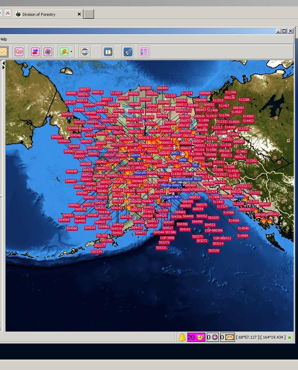
Alaska Interagency Center map of currently active wildfires now burning in Alaska.
With 42 hours left in June and with more than 300 fires still active, it’s pretty clear that the current fire season is a historic, unprecedented, record-shattering event. One that will almost certainly break the 2 million acre mark and may show double the over-all previous record burning during June of 2004. An excessive new record that is occurring in the ominous context of the hottest year in the global climate record and a vastly irresponsible dumping of 50 billion tons of heat-trapping, CO2 equivalent (of which 32 billion tons is CO2) gasses into the atmosphere through fossil fuel burning and related industry each and every year.
As Alaska Experiences Worst Ever Burning for June, Northwest Territory Lights Up
As Alaska burned through half a million acres of forest in just one day, a massive heatwave was also setting off extreme wildfires throughout northwest Canada. It was the same heatwave that broke new temperature records all across Washington, and the mountain west. Temperatures in places like Walla, Walla Washington, hit 113 degrees Fahrenheit (45 Celsius) on Sunday — breaking the previous all time June temperature record for the day by 4 degrees (2.2 C). A pulse of heat rising off the back of a strengthening El Nino in the Pacific, running all the way up the western seaboard and mountains of the US and driving deep into northwestern Canada.
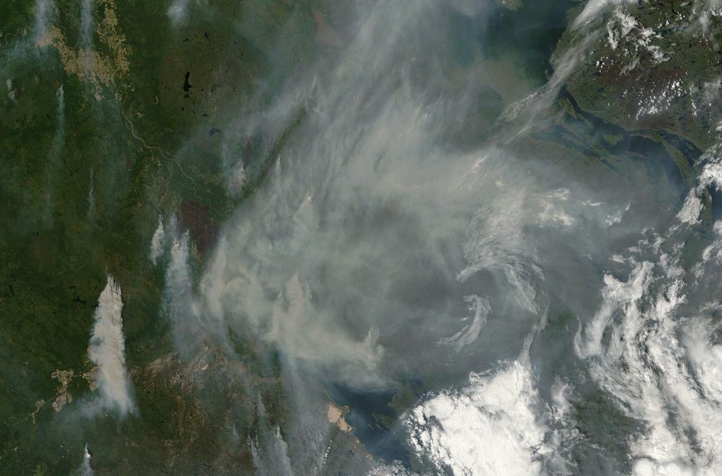
Massive plumes of smoke emitting from wildfires burning near Great Slave Lake in Northwest Territory, Canada on Sunday. For reference, bottom edge of frame is 350 miles. Image source: LANCE-MODIS.
The added heat riled wildfires burning throughout much of the permafrost zone in Canada, pushing blazes to explosive size and dumping massive plumes of smoke into an atmosphere already heavily laden with Alaska’s brown carbon pulse. In the above LANCE-MODIS image we can see about 30 of these fires burning away near Great Slave Lake. Note that some of the fire fronts in the above image are more than 15 miles long.
Given the satellite assessment from yesterday, it appears that the same excessive heat, dryness and permafrost thaw that has set off record fires for Alaska during June is now also in play for Canada. Initial reports from Canada’s Interagency Fire Center confirm this assessment with 138 new fires erupting in just the past 24 hours alone and more than 2,250,000 acres burned for the country since the start of 2015. As a result of the excessive Arctic heat (associated with both El Nino and overall human warming) and extreme rate of new fire starts, we are at risk of seeing unprecedented wildfire conditions continuing to spread throughout this warming, vulnerable Arctic region.
UPDATE: Preliminary numbers for acres burned in Alaska, according to Interagency Center reports have been downgraded somewhat to greater than 1.6 million total acres burned. These totals are still in record range with between 200,000 to 300,000 acres burned each day. It seems, given the unprecedented number and intensity of fires now burning (currently 300) in AK that there’s some difficulty getting an accurate assessment of conditions on the ground. The downgrade is somewhat good news in light of an overall difficult and record fire season for Alaska. Will keep updating as new information becomes available.
Links:
Hat Tip to Andy in San Diego
Hat Tip to Colorado Bob
Hat Tip to Greg
Hat Tip to DT Lange
(Please help support public, government-funded climate change resiliency efforts like those aided by various interagency fire centers within the US and Canada in addition to the critically valuable satellite tracking provided by the amazing scientific and research teams at NASA.)


No comments:
Post a Comment