Blog Archive

Showing posts with label mesoscale convective systems. Show all posts

Thursday, January 4, 2018

Michael Mann: A 'Perfect' Storm: Extreme Winter Weather, Bitter Cold, and Climate Change

by Michael Mann, The Climate Reality Project, January 4, 2018
The US East Coast is experiencing an “old-fashioned” winter, with plenty of cold weather and some heavy snowfall in certain places. Listening to climate contrarians like President Donald Trump, you might think this constitutes the death knell for concern over human-caused climate change.
Yet, what we were witnessing play out is in fact very much consistent with our expectations of the response of weather dynamics to human-caused climate change.
Let’s start with the record five-plus feet of snowfall accumulation in Erie, Pennsylvania, in late December. Does this disprove global warming? “Exactly the opposite,” explains my colleague, Dr. Katharine Hayhoe of Texas Tech University. 
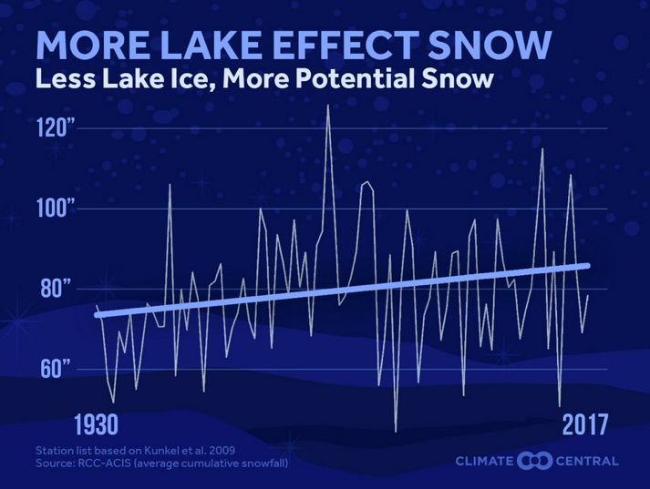
Global warming is leading to later freeze-up of the Great Lakes and warmer lake temperatures. It is the collision of cold Arctic air with relatively warm unfrozen lake water in early winter that causes lake effect snows in the first place. The warmer those lake temperatures, the more moisture in the air, and the greater potential for lake effect snows. Not surprisingly, we see a long-term increase in lake effect snowfalls as temperatures have warmed during the last century (see figure below).
iew image on Twitter
How about those frigid low temperatures back east this winter? Surely that extreme cold must disprove global warming?
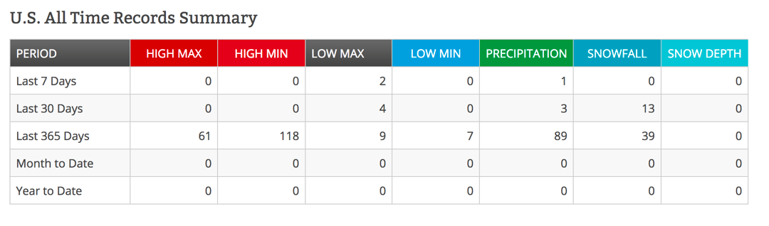
Once again, the claim is misguided. While we have seen some daily all-time lows for a smattering of locations in the US, these pale in comparison with the number of all-time highs we’ve seen over the past year. In fact, the record highs have outpaced the record lows 61 to seven, i.e. nine times more often (see table below), consistent with what we expect to see as the globe continues to warm.
../../../../Desktop/Screen%20Shot%202018-01-03%20at%205.16.4
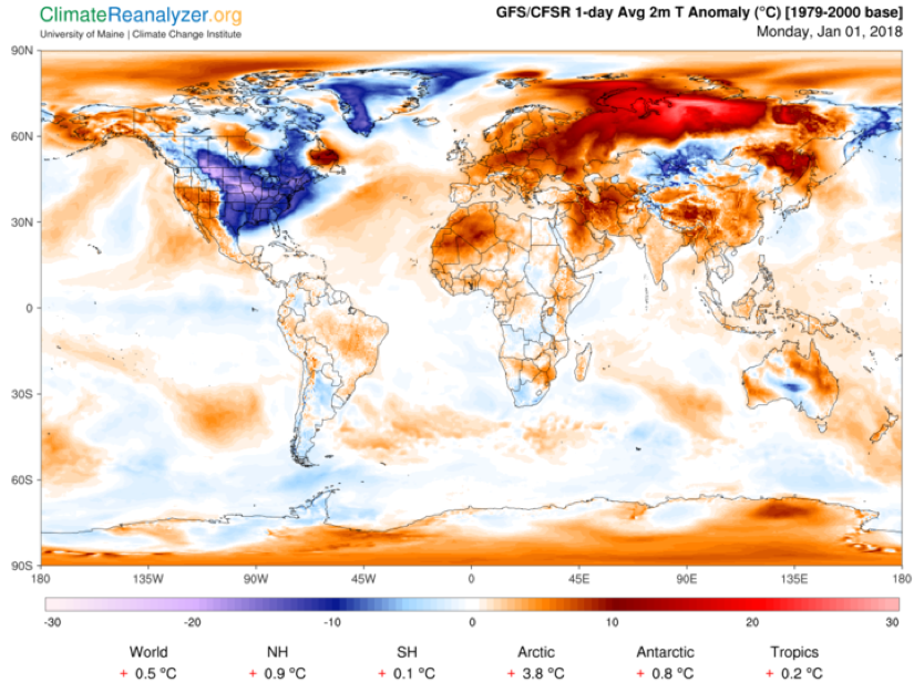
Moreover, while we’ve seen some cold weather in the eastern half of the North America (see the pattern for New Year’s Day below), the western half of North America has been unusually warm. Indeed, most of the Northern Hemisphere, and the globe overall, have been unusually warm. That’s why we call it global warming, folks.
ttps://img.huffingtonpost.com/asset/5a4ac2201c00003b0068e12d.png?ops=scalefit_720_noupscale
(Image obtained using Climate Reanalyzer, Climate Change Institute, University of Maine, USA)
But what about this pattern of cold in the eastern US and warm in the western US? This so-called “dipole” pattern has become more common in recent winters, and recent research suggests that climate change may be favoring this contrast in temperature by causing the jet stream to meander in a particular pattern, with an upward meander or “ridge” in the west bringing warm air up from the south and a downward meander or “trough” in the east, bringing cold air down from the north. Some scientists think that the dramatic loss of sea ice in the Arctic may be favoring this jet stream pattern.
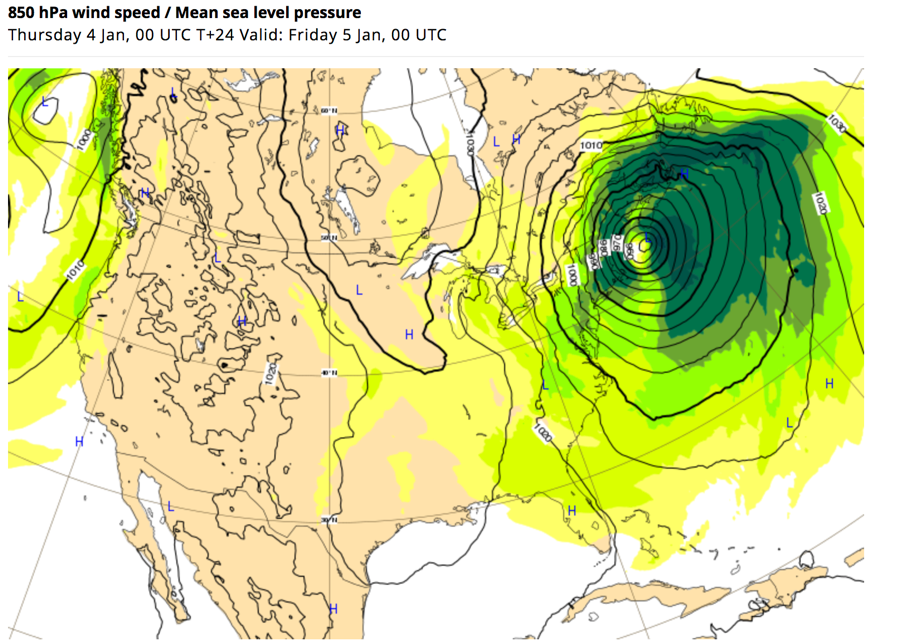
Finally, the news is abuzz today with an impending “massive Nor’easter,” a “bomb cyclone” that is “set to explode” in the days ahead (see plot below). This isn’t just hype. The National Weather Service has warned that “this rapidly intensifying East Coast storm will produce strong, damaging winds — possibly resulting in downed trees, power outages, and coastal flooding.”
With a central pressure forecast to drop very low (see plot below), the storm will threaten the record set by unprecedented 2012 Superstorm Sandy as the lowest surface pressure ever measured in the North Atlantic north of Cape Hatteras (the central surface pressure of a storm is one measure of its strength).
(© 2018 ECMWF cc by nc nd 4.0)
Surely such a massive winter storm, with its promise of bitter cold winds and potentially heavy coastal snowfalls, must be evidence against the climate crisis?
Once again, rather the opposite is true. East Coast winter storms, known as “nor’easters” because of the unusual northeasterly direction of the winds as the storm spirals in from the south, are unusual in that they derive their energy not just from large contrasts in temperature that drive most extratropical storm systems, but also from the energy released when water evaporates from the (relatively warm) ocean surface into the atmosphere.
This is a characteristic that these storms share with tropical storms and hurricanes. The warmer the ocean surface, the more energy that is available to intensify these storms. And the warmer the ocean surface, the more moisture there is in the atmosphere – moisture that is available to form precipitation. As the winds wrap around in a counter-clockwise manner, they bring all of that moisture northwest, where it is chilled and ultimately falls not as rain but snow. Lots of snow.
As the oceans continue to warm, cold Arctic air masses collide with increasingly warm Atlantic Ocean waters. That means larger temperature contrasts and potentially stronger storms. But those warmer oceans also mean more moisture in the atmosphere, even more energy to strengthen the storm, and the potential for larger snowfalls.  We might, if you’ll forgive the pun, call this a “perfect storm” of factors for intensification.
Indeed, climate model simulations indicate that we can expect more intense nor’easters as human-caused climate change continues to warm the oceans.
Screen%20Shot%202018-01-03%20at%202.11.16%20PM.png
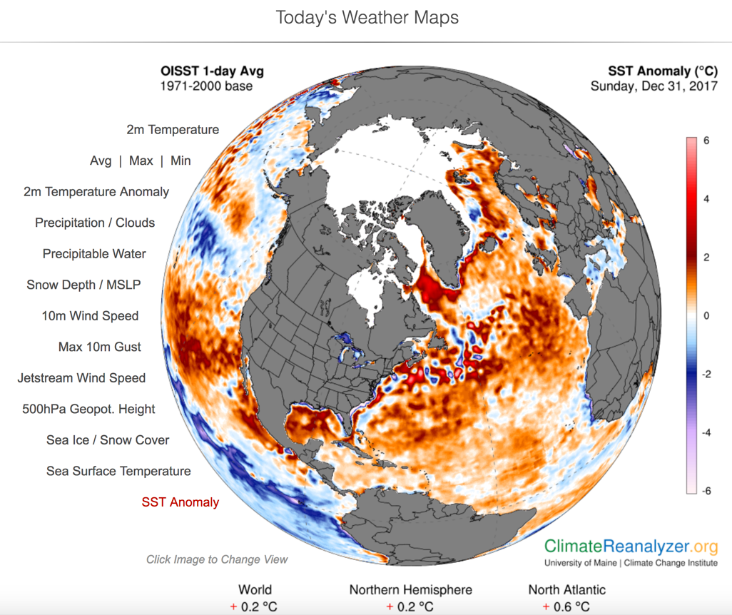
(Image obtained using Climate Reanalyzer, Climate Change Institute, University of Maine, USA)
This leads us back to the current strengthening storm. The entire North Atlantic is unusually warm right now (+0.6 degrees Celsius) relative to the already-globally-warmed, late-twentieth-century average (1971-2000), and there are large patches of ocean water off the US East Coast that are 2-4 degrees Celsius above that average. The storm will be encountering that exceptional ocean heat as it travels northward along the US coastline, and that is part of why it has a very good chance of becoming the most intense nor’easter we’ve yet observed.
So, to the climate change doubters and deniers out there, the unusual weather we’re seeing this winter is in no way evidence against climate change. It is an example of precisely the sort of extreme winter weather we expect because of climate change.
Stay up to date with the latest in climate fight and insight from influential scientists and voices like Dr. Mann by signing up for our activist email list today.
Dr. Michael Mann is distinguished professor of atmospheric science at Penn State University and author of The Hockey Stick and The Climate Wars and, more recently, The Madhouse Effect.

https://www.climaterealityproject.org/blog/perfect-storm-extreme-winter-weather-bitter-cold-and-climate-change

"Increased rainfall volume from future convective storms in the US" by Andreas Prein et al., Nature Climate Change, 7 (2017); doi: 10.1038/s41558-017-0007-7

Nature Climate Change, 7 (2017) 880884; doi: 10.1038/s41558-017-0007-7

Increased rainfall volume from future convective storms in the US

Mesoscale convective system (MCS)-organized convective storms with a size of ~100 km have increased in frequency and intensity in the USA over the past 35 years1, causing fatalities and economic losses2. However, their poor representation in traditional climate models hampers the understanding of their change in the future3. Here, a North American-scale convection-permitting model which is able to realistically simulate MSCs4 is used to investigate their change by the end-of-century under RCP8.5 (ref. 5). A storm-tracking algorithm6 indicates that intense summertime MCS frequency will more than triple in North America. Furthermore, the combined effect of a 15–40% increase in maximum precipitation rates and a significant spreading of regions impacted by heavy precipitation results in up to 80% increases in the total MCS precipitation volume, focused in a 40-km radius around the storm center. These typically neglected increases substantially raise future flood risk. Current investments in long-lived infrastructures, such as flood protection and water management systems, need to take these changes into account to improve climate-adaptation practices.


North American Storm Clusters Could Produce 80 Percent More Rain Say NCAR Scientists

by Floodlist News, November 28, 2017

Major clusters of summertime thunderstorms in North America will grow larger, more intense, and more frequent later this century in a changing climate, unleashing far more rain and posing a greater threat of flooding across wide areas, new research concludes.

The study, by scientists at the National Center for Atmospheric Research (NCAR), builds on previous work showing that storms are becoming more intense as the atmosphere is warming. In addition to higher rainfall rates, the new research finds that the volume of rainfall from damaging storms known as mesoscale convective systems (MCSs) will increase by as much as 80% across the continent by the end of this century, deluging entire metropolitan areas or sizable portions of states.


“The combination of more intense rainfall and the spreading of heavy rainfall over larger areas means that we will face a higher flood risk than previously predicted,” said NCAR scientist Andreas Prein, the study’s lead author. “If a whole catchment area gets hammered by high rain rates, that creates a much more serious situation than a thunderstorm dropping intense rain over parts of the catchment.”
“This implies that the flood guidelines which are used in planning and building infrastructure are probably too conservative,” he added.
The research team drew on extensive computer modeling that realistically simulates MCSs and thunderstorms across North America to examine what will happen if emissions of greenhouse gases continue unabated.
The study will be published November 20, 2017, in the journal Nature Climate Change. It was funded by the National Science Foundation, which is NCAR’s sponsor, and by the U.S. Army Corps of Engineers.


Hourly rain rate averages for the 40 most extreme summertime mesoscale convective systems (MCSs) in the current (left) and future climate of the mid-Atlantic region. New research shows that MSCs will generate substantially higher maximum rain rates over larger areas by the end of the century if society continues a “business as usual” approach of emitting greenhouse gases . Image: ©UCAR, Image by Andreas Prein, NCAR.

This satellite image loop shows an MCS developing over West Virginia on June 23, 2016. The resulting floods caused widespread flooding, killing more than 20 people. MCSs are responsible for much of the major flooding east of the Continental Divide during warm weather months. (Image by NOAA National Weather Service, Aviation Weather Center.)

A Warning Signal

Thunderstorms and other heavy rainfall events are estimated to cause more than $20 billion of economic losses annually in the United States, the study notes. Particularly damaging, and often deadly, are MSCs: clusters of thunderstorms that can extend for many dozens of miles and last for hours, producing flash floods, debris flows, landslides, high winds, and/or hail. The persistent storms over Houston in the wake of Hurricane Harvey were an example of an unusually powerful and long-lived MCS.
Storms have become more intense in recent decades, and a number of scientific studies have shown that this trend is likely to continue as temperatures continue to warm. The reason, in large part, is that the atmosphere can hold more water as it gets warmer, thereby generating heavier rain.
A study by Prein and co-authors last year used high-resolution computer simulations of current and future weather, finding that the number of summertime storms that produce extreme downpours could increase by five times across parts of the United States by the end of the century. In the new study, Prein and his co-authors focused on MCSs, which are responsible for much of the major summertime flooding east of the Continental Divide. They investigated not only how their rainfall intensity will change in future climates, but also how their size, movement, and rainfall volume may evolve.
Analyzing the same dataset of computer simulations and applying a special storm-tracking algorithm, they found that the number of severe MCSs in North America more than tripled by the end of the century. Moreover, maximum rainfall rates became 15-40% heavier, and intense rainfall reached farther from the storm’s center. As a result, severe MCSs increased throughout North America, particularly in the northeastern and mid-Atlantic states, as well as parts of Canada, where they are currently uncommon.
The research team also looked at the potential effect of particularly powerful MCSs on the densely populated Eastern Seaboard. They found, for example, that at the end of the century, intense MCSs over an area the size of New York City could drop 60% more rain than a severe present-day system. That amount is equivalent to adding six times the annual discharge of the Hudson River on top of a current extreme MCS in that area.
“This is a warning signal that says the floods of the future are likely to be much greater than what our current infrastructure is designed for,” Prein said. “If you have a slow-moving storm system that aligns over a densely populated area, the result can be devastating, as could be seen in the impact of Hurricane Harvey on Houston.”

Intensive Modeling

Advances in computer modeling and more powerful supercomputing facilities are enabling climate scientists to begin examining the potential influence of a changing climate on convective storms such as thunderstorms, building on previous studies that looked more generally at regional precipitation trends.
For the new study, Prein and his co-authors turned to a dataset created by running the NCAR-based Weather and Research Forecasting (WRF) model over North America at a resolution of 4 kilometers (about 2.5 miles). That is sufficiently fine-scale resolution to simulate MCSs. The intensive modeling, by NCAR scientists and study co-authors Roy Rasmussen, Changhai Liu, and Kyoko Ikeda, required a year to run on the Yellowstone system at the NCAR-Wyoming Supercomputing Center.
The team used an algorithm developed at NCAR to identify and track simulated MCSs. They compared simulations of the storms at the beginning of the century, from 2000 to 2013, with observations of actual MCSs during the same period, and showed that the modeled storms are statistically identical to real MCSs.
The scientists then used the dataset and algorithm to examine how MCSs may change by the end of the century in a climate that is approximately 5 degrees Celsius (9 degrees Fahrenheit) warmer than in the pre-industrial era — the temperature increase expected if greenhouse gas emissions continue unabated.

About the paper

Title: Increased rainfall volume from future convective storms in the US
Authors: Andreas F Prein, Changhai Liu, Kyoko Ikeda, Stanley B Trier, Roy M Rasmussen, Greg J Holland, Martyn P Clark
Source: University Corporation for Atmospheric Research

Sunday, May 7, 2017

Catastrophic mesoscale convective system storms in the Sahel now three times more likely

Climate change brings more Sahel storms

Climate change is upsetting rainfall patterns and the frequency of flooding in West Africa as it makes the region's Sahel storms three times likelier.


by Tim Radford, Climate News Network, May 7, 2017

LONDON 
– Climate change has already made a difference to life in the West African Sahel, the arid belt of land stretching from the Atlantic to the Red Sea which separates the Sahara desert from the African savanna. It has made catastrophic storms three times more frequent.

And, according to a new study in the journal Nature, Sahel storms are among the most powerful on the planet. In 2009, one vast downpour deposited 263 mm of rain over Ouagadougou, the capital of Burkina Faso, claiming 8 lives, flooding half the city and forcing 150,000 people out of their homes.

Researchers believe the pattern of thunderstorms known as mesoscale convective systems will increase in frequency as global temperatures rise, as a consequence of increasing levels of carbon dioxide in the atmosphere, in turn driven by worldwide use of fossil fuels as sources of energy.

Mesoscale convective systems are big, bad, and very cold columns of thunderous cloud: up to 16 km high, covering an area of 25,000 square kilometres, and with temperatures at the highest altitude as low as minus 40 °C.

Between 1986 and 2005, Burkina Faso registered floods at a rate of little more than one a year. In the 11 years between 2006 and 2016, it was hit by 55 flood events.

Repeated warnings

Climate scientists have been warning for three decades that global warming will be accompanied by an increase in “extreme” events: in particular drought, flood, heat wave, and tropical cyclone.

Global warming has already been observed in the Sahel, and the consequences have not necessarily been bad: overall, precipitation has increased, and farmers have benefited, although in a dryland region south of the Sahara where people have endured a 2,000-year history of periodic drought, famine remains a constant hazard.

And now, so do massive downpours of rain: the Sahel storms. British and French scientists examined 35 years of satellite data and the rain gauges in the region to identify a rise in extreme daily rainfall totals. They found 85% of extreme rainfall cases coincided with satellite records of a passing mesoscale convection system.

They also examined the pattern of temperatures over the region and found that although the annual average temperatures have risen, the so-called “wet season” temperatures have remained steady. That is, locally warmer conditions alone have not brought more rainfall.

“Global warming is expected to produce more intense storms, but we were shocked to see the speed of changes taking place in this region of Africa”

Instead, they blame man-made global warming which has changed wind and rain conditions, and this will go on strengthening during this century, “suggesting the Sahel will experience particularly marked increases in extreme rain,” they conclude.

“Global warming is expected to produce more intense storms, but we were shocked to see the speed of changes taking place in this region of Africa,” said Christopher Taylor, a meteorologist at the UK’s Centre for Ecology and Hydrology, who led the study.

His co-author Douglas Parker, professor of meteorology at the University of Leeds in the UK, said: “African storms are highly organised meteorological engines, whose currents extract water from the air to produce torrential rain.

“We have seen these engines becoming more efficient over recent decades, with resulting increases in the frequency of hazardous events.” 


http://climatenewsnetwork.net/climate-change-brings-more-sahel-storms

