Blog Archive

Showing posts with label Consequences to infrastructure. Show all posts

Thursday, July 19, 2018

Rising sea levels will soon destroy underground US internet cables, scientists warn

'The expectation was that we'd have 50 years to plan for it. We don't have 50 years'

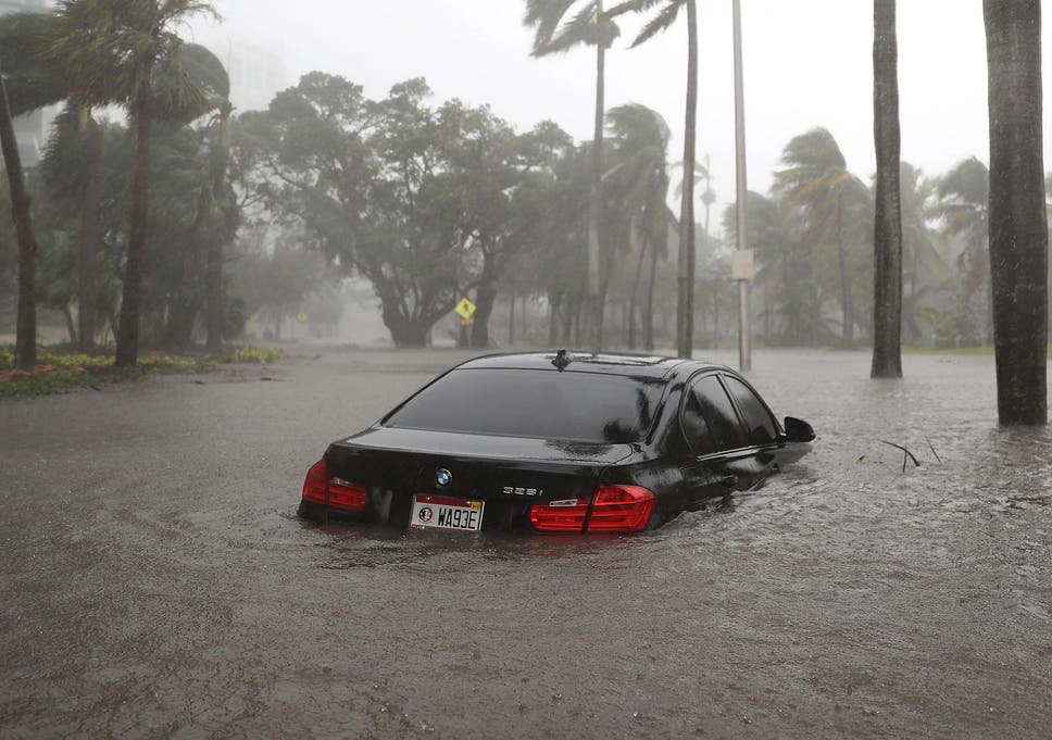
Coastal cities like Miami have already experienced serious flooding thanks to recent hurricanes, and researchers warn that inundation with water could endanger the region's internet infrastructure


Coastal cities like Miami have already experienced serious flooding thanks to recent hurricanes, and researchers warn that inundation with water could endanger the region's internet infrastructure

Coastal cities like Miami have already experienced serious flooding thanks to recent hurricanes, and researchers warn that inundation with water could endanger the region's internet infrastructure ( Joe Raedle/Getty Images )

by Josh Gabbatiss, Science Correspondent, The Independent, July 17, 2018

Underground internet cables criss-crossing coastal regions will be inundated by rising seas within the next 15 years, according to a new study.
Thousands of miles of fibre optic cables are under threat in US cities like New York, Seattle and Miami, and could soon be out of action unless steps are taken to protect them.
The report, presented at a meeting of internet network researchers in Montreal, is among the first to reveal the damage a changing climate will cause for the network of cables and data centres that underpins so much of modern life.
What shocked computer scientist Professor Paul Barford and his colleagues most when they investigated the effect of rising tides on US cities was the speed at which the internet will be compromised.
"Most of the damage that's going to be done in the next 100 years will be done sooner than later," said Professor Barford, a researcher at the University of Wisconsin-Madison.
"That surprised us. The expectation was that we'd have 50 years to plan for it. We don't have 50 years."
Most of this infrastructure was constructed around 25 years ago along trails running parallel with highways and coastlines, with no thought given to how geography would alter as the climate changed.
In their study, presented at the Applied Networking Research Workshop, the scientists combined a comprehensive map of the internet’s physical structure with projections of sea level rise produced by the US National Oceanic and Atmospheric Administration (NOAA).
The most at-risk stretches of cable were unsurprisingly those already close to sea level, meaning the slight increases predicted for the next few years will be enough to cover them.
The researchers estimated that in total more than 4,000 miles of buried fibre optic cable in the US will be submerged by 2033.
Massive underwater internet cables link North America with the rest of the world, and the landing points where these cables end will be submerged “in a short period of time”, according to Professor Barford.
While the large transoceanic cables are completely waterproof, the buried smaller fibre optic cables are not and if they are submerged there could be far-reaching impacts not only in the coastal US but potentially around the world.
Flooding in coastal cities has been acknowledged as a major threat, and many areas have already begun building hardy sea walls to prepare for the worst. Professor Barford said such preparations will go some way to protecting the internet, but will probably not be enough.
"The first instinct will be to harden the infrastructure," said Professor Barford. 
"But keeping the sea at bay is hard. We can probably buy a little time, but in the long run it's just not going to be effective."
Professor Barford said recent hurricanes and storm surges in the eastern US had already given a taste of the kind of flooding that is to come. He said this study should serve as a “wake-up call” that prompts a discussion about how to protect the world’s precious internet from climate change.
Efforts have also been made in the UK to predict the impact of climate change on the nation’s digital infrastructure, with the major threats thought to be “flooding from increased winter rainfall, changes to humidity and temperature and high winds.”
https://www.independent.co.uk/environment/sea-levels-rise-internet-cables-climate-change-underground-new-york-miami-a8449716.html

Sunday, February 11, 2018

Ted Glick: Helping in Puerto Rico

by Ted Glick, February 11, 2018

From January 28 to February 7, my wife and I were in Vieques, Puerto Rico, helping as best we could with recovery from Hurricane Maria, which hit on September 20th, almost five months ago.  Help is very much still needed. I don’t think I realized how much that is true until I got home to New Jersey and experienced all of the things I didn’t experience during those 10 days:
  • the lights and everything electrical turning on or being on all day and night whenever I need it;
  • a hot, not cold, water shower;
  • not worrying about hitting something or falling when I had to get up and go to the bathroom or move around at night;
  • not hearing (or smelling) loud gas generators behind the house where I was staying and several other places in the neighborhood as day turned into night;
  • not having to do extra-special filtering of the tap water because of concerns about its quality;
  • reliably accessing my cell phone apps, telephone and the internet whenever I want to.

These were the main differences.
I was staying at Casa de Kathy in Esperanza, the second largest town in Vieques. The only street in Esperanza that fully had electrical power when we were there was the Malecon, the downtown street next to the water where bars, restaurants, and hotels are, and they didn’t get that power until the fifth day we were there. What electrical power there was elsewhere in town came from gas-powered generators bought by residents who could afford them.
There was concern about the tap water. Neither the EPA nor anyone else had done tests to determine how safe it is to drink.
There were still piles of debris and branches that had been blown down by the storm, as well as collections of stoves and refrigerators disabled by it.
Despite all of these serious problems, the sense I had was that people in general were pulling together, some more than others, to climb out of the hole the hurricane put them in. They were doing so even though there was a lot of criticism of FEMA for its slowness and for it denying aid to a number of people whose homes had been damaged.
I was glad to learn that the use of solar energy, in different forms, is growing, from small solar lights, which are popular, to solar panels on roofs to provide an alternative to an unreliable electric grid.
One of the big takeaways for me was the reinforcement of something I have known intellectually for years, that extreme weather events, like the climate changing which makes them worse and more frequent, hurts low-income people the most. Middle- and upper-class people who have access to financial and other resources had found ways to lessen their suffering or discomfort, like through personal generators. But those without those resources were in a different situation. I heard of at least one family that was sleeping in a tent in their living room because there had been serious damage to their roof that they had not yet been able to afford getting fixed.
The pro-statehood Governor of Puerto Rico, Ricardo Rossello, announced just before we got there that he wanted to privatize that electrical system, currently publicly owned, which would certainly lead to higher electrical rates for many struggling Puerto Rican consumers as the corporate buyer looks to make its profits.
Then there is the relatively large Puerto Rican debt (though hugely smaller than the US debt) of $73 billion. There have been calls for that debt to be forgiven, for obvious reasons. Lin-Manual Miranda, for example, creator and star of the Broadway hit “Hamilton,” called for that in a December opinion piece in the Washington Post. He wrote:
“Puerto Rico’s creditors should do the right thing and walk away. It is the only way forward. Anything short of full debt forgiveness would be a brutal form of economic punishment to a people already suffering.”
But to add insult to injury, the Republican tax bill passed at the end of 2017, unless challenged and changed, will make things even worse.
A December 20 Washington Post story reported that the Puerto Rican Governor “is calling on lawmakers to rewrite a key part of the tax bill that he says might cause the island’s hefty manufacturing sector to contract, jeopardizing hundreds of thousands of jobs. [It] includes a new 12.5% tax on profits derived from intellectual property held by foreign companies — a move designed to compel those companies to move back to the United States. The new tax ‘is a big hit, and Puerto Rico both fiscally and economically is downtrodden, and this is the last thing they need,’ said Federico de Jesus, a former Puerto Rico government official who has been tracking congressional relief efforts for the island.”
US citizens have a special responsibility to help Puerto Rico, which has been a colony of the United States since 1898. It is our humanitarian and moral responsibility, and it is our duty as citizens of the nation which has the power to help Puerto Rico either move forward or backwards after Maria. We must do what we can as far as practical hurricane recovery support but also support groups calling for a cancellation of the debt, changes to the Republican tax bill, and reform of the electric power system, not its privatization.

Ted Glick is a former activist with the Puerto Rico Solidarity Committee in the 1970s. He was a supporter of the historic civil disobedience campaign in Vieques in the early 2000s, which led to the removal of the US Navy. He has been a progressive activist and organizer since 1968. Past writings and other information can be found at http://tedglick.com, and he can be followed on Twitter at http://twitter.com/jtglick.
https://tedglick.com/future-hope-columns/helping-in-puerto-rico/

Monday, January 22, 2018

Lenders' Guide for Considering Climate Risk in Infrastructure Investments, January 2018

AcclimatiseClimate Finance Advisors (CFA), and Four Twenty Seven have released a new guidance document to increase the climate resilience of large infrastructure investments. The “Lenders’ Guide for Considering Climate Risk in Infrastructure Investments” clearly breaks down the ways in which physical climate risks might affect key financial aspects of prospective infrastructure investments. 

This guide provides a framework for questioning how revenues, costs, and assets can be linked to potential project vulnerability arising from climate hazards and draws attention to the potential opportunities emerging from resilience-oriented investments in infrastructure.

Ten sub-sectors, including airports, marine ports, gas and oil transport and storage, power transmission and distribution, wind-based power generation, data centers, telecommunications, commercial real estate, healthcare, and sports and entertainment, are analysed and illustrated with topical examples.

To learn more about this document, please visit our website and download the publication here.

Download the guide at this link:

http://www.acclimatise.uk.com/wp-content/uploads/2018/01/Lenders_Guide_for_Considering_Climate_Risk_in_Infrastructure_Investments.pdf

Wednesday, January 17, 2018

2017’s costly climate change-fueled disasters are the ‘new normal,’ warns major reinsurer Munich Re

“We have a new normal” thanks to climate change, explains leading reinsurer.


by Joe Romm, Climate Progress, January 4, 2018


Hurricane Harvey Impacts. CREDIT: Getty Images
HURRICANE HARVEY IMPACTS. CREDIT: GETTY IMAGES


It turns out 2017 was a uniquely disastrous year in more ways than one, evidenced by German reinsurer Munich Re’s recently released review of the year’s global catastrophes.
Led by massive, climate change-fueled hurricanes Harvey, Irma, and Maria, 2017’s natural disasters will cost insurers a record $135 billion. Adding in uninsured losses brings the total global damages to $330 billion, which is second only to 2011.
“We have a new normal,” Munich Re’s Ernst Rauch told Reuters. Rauch, who runs the group tracking climate change risks, pointed out that “2017 was not an outlier” in having more than $100 billion in insured losses (see chart below). “We must have on our radar the trend of new magnitudes,” Rauch said.
The big reinsurers like Munich Re make their money by insuring the companies that directly insure your property. Those smaller companies are often required by law to buy reinsurance because they lack the capital resources to pay out if there is a major disaster, like superstorm Harvey for instance.
Since the reinsurers must pay out billions and billions of dollars for such mega-disasters, they have a unique incentive to understand and predict trends in mega-disasters. That’s why companies like Munich Re and Swiss Re have been at the forefront of warning businesses and the public about the rise in extreme weather events due to climate change.
Indeed, back in September 2010, another year of stunning warming-driven extreme weather events, Munich Re issued a release noting it had analyzed its catastrophe database, “the most comprehensive of its kind in the world,” and concluded, “the only plausible explanation for the rise in weather-related catastrophes is climate change.” 
Then in October 2012, the company released a massive 274-page report, “Severe weather in North America,” analyzing weather catastrophes and related losses since 1980 to understand trends and their causes, including man-made climate change.
Munich Re found that the number of weather-related loss disasters has been rising much faster in North America than anywhere else, and concluded, “Climate-driven changes are already evident over the last few decades for severe thunderstorms, for heavy precipitation and flash flooding, for hurricane activity, and for heatwave, drought and wild­fire dynamics in parts of North America.”
Prof. Peter Höppe, who heads Munich Re’s Geo Risks Research unit, said at the time, “In all likelihood, we have to regard this finding as an initial climate-change footprint in our U.S. loss data from the last four decades.”
And last April, Munich Re published an article on “rapid attribution,” which explained that we can now rapidly determine how much intensity or frequency of some extreme weather events is affected by man-made climate change. Learning that, for instance, climate change has sharply increased the chances of individual extreme rain and flooding events – such as devastating August 2016 deluge and flooding of Baton Rouge, Louisiana – allows communities to do better planning and Munich Re to do better risk management.
The latest annual report amplifies the message that humans are changing the climate, boosting the intensity and frequency of extreme weather events, and that the longer we dawdle, the higher the costs we will incur. The only question is, is anyone listening?

Thursday, January 4, 2018

"Increased rainfall volume from future convective storms in the US" by Andreas Prein et al., Nature Climate Change, 7 (2017); doi: 10.1038/s41558-017-0007-7

Nature Climate Change, 7 (2017) 880884; doi: 10.1038/s41558-017-0007-7

Increased rainfall volume from future convective storms in the US

Mesoscale convective system (MCS)-organized convective storms with a size of ~100 km have increased in frequency and intensity in the USA over the past 35 years1, causing fatalities and economic losses2. However, their poor representation in traditional climate models hampers the understanding of their change in the future3. Here, a North American-scale convection-permitting model which is able to realistically simulate MSCs4 is used to investigate their change by the end-of-century under RCP8.5 (ref. 5). A storm-tracking algorithm6 indicates that intense summertime MCS frequency will more than triple in North America. Furthermore, the combined effect of a 15–40% increase in maximum precipitation rates and a significant spreading of regions impacted by heavy precipitation results in up to 80% increases in the total MCS precipitation volume, focused in a 40-km radius around the storm center. These typically neglected increases substantially raise future flood risk. Current investments in long-lived infrastructures, such as flood protection and water management systems, need to take these changes into account to improve climate-adaptation practices.


North American Storm Clusters Could Produce 80 Percent More Rain Say NCAR Scientists

by Floodlist News, November 28, 2017

Major clusters of summertime thunderstorms in North America will grow larger, more intense, and more frequent later this century in a changing climate, unleashing far more rain and posing a greater threat of flooding across wide areas, new research concludes.

The study, by scientists at the National Center for Atmospheric Research (NCAR), builds on previous work showing that storms are becoming more intense as the atmosphere is warming. In addition to higher rainfall rates, the new research finds that the volume of rainfall from damaging storms known as mesoscale convective systems (MCSs) will increase by as much as 80% across the continent by the end of this century, deluging entire metropolitan areas or sizable portions of states.


“The combination of more intense rainfall and the spreading of heavy rainfall over larger areas means that we will face a higher flood risk than previously predicted,” said NCAR scientist Andreas Prein, the study’s lead author. “If a whole catchment area gets hammered by high rain rates, that creates a much more serious situation than a thunderstorm dropping intense rain over parts of the catchment.”
“This implies that the flood guidelines which are used in planning and building infrastructure are probably too conservative,” he added.
The research team drew on extensive computer modeling that realistically simulates MCSs and thunderstorms across North America to examine what will happen if emissions of greenhouse gases continue unabated.
The study will be published November 20, 2017, in the journal Nature Climate Change. It was funded by the National Science Foundation, which is NCAR’s sponsor, and by the U.S. Army Corps of Engineers.


Hourly rain rate averages for the 40 most extreme summertime mesoscale convective systems (MCSs) in the current (left) and future climate of the mid-Atlantic region. New research shows that MSCs will generate substantially higher maximum rain rates over larger areas by the end of the century if society continues a “business as usual” approach of emitting greenhouse gases . Image: ©UCAR, Image by Andreas Prein, NCAR.

This satellite image loop shows an MCS developing over West Virginia on June 23, 2016. The resulting floods caused widespread flooding, killing more than 20 people. MCSs are responsible for much of the major flooding east of the Continental Divide during warm weather months. (Image by NOAA National Weather Service, Aviation Weather Center.)

A Warning Signal

Thunderstorms and other heavy rainfall events are estimated to cause more than $20 billion of economic losses annually in the United States, the study notes. Particularly damaging, and often deadly, are MSCs: clusters of thunderstorms that can extend for many dozens of miles and last for hours, producing flash floods, debris flows, landslides, high winds, and/or hail. The persistent storms over Houston in the wake of Hurricane Harvey were an example of an unusually powerful and long-lived MCS.
Storms have become more intense in recent decades, and a number of scientific studies have shown that this trend is likely to continue as temperatures continue to warm. The reason, in large part, is that the atmosphere can hold more water as it gets warmer, thereby generating heavier rain.
A study by Prein and co-authors last year used high-resolution computer simulations of current and future weather, finding that the number of summertime storms that produce extreme downpours could increase by five times across parts of the United States by the end of the century. In the new study, Prein and his co-authors focused on MCSs, which are responsible for much of the major summertime flooding east of the Continental Divide. They investigated not only how their rainfall intensity will change in future climates, but also how their size, movement, and rainfall volume may evolve.
Analyzing the same dataset of computer simulations and applying a special storm-tracking algorithm, they found that the number of severe MCSs in North America more than tripled by the end of the century. Moreover, maximum rainfall rates became 15-40% heavier, and intense rainfall reached farther from the storm’s center. As a result, severe MCSs increased throughout North America, particularly in the northeastern and mid-Atlantic states, as well as parts of Canada, where they are currently uncommon.
The research team also looked at the potential effect of particularly powerful MCSs on the densely populated Eastern Seaboard. They found, for example, that at the end of the century, intense MCSs over an area the size of New York City could drop 60% more rain than a severe present-day system. That amount is equivalent to adding six times the annual discharge of the Hudson River on top of a current extreme MCS in that area.
“This is a warning signal that says the floods of the future are likely to be much greater than what our current infrastructure is designed for,” Prein said. “If you have a slow-moving storm system that aligns over a densely populated area, the result can be devastating, as could be seen in the impact of Hurricane Harvey on Houston.”

Intensive Modeling

Advances in computer modeling and more powerful supercomputing facilities are enabling climate scientists to begin examining the potential influence of a changing climate on convective storms such as thunderstorms, building on previous studies that looked more generally at regional precipitation trends.
For the new study, Prein and his co-authors turned to a dataset created by running the NCAR-based Weather and Research Forecasting (WRF) model over North America at a resolution of 4 kilometers (about 2.5 miles). That is sufficiently fine-scale resolution to simulate MCSs. The intensive modeling, by NCAR scientists and study co-authors Roy Rasmussen, Changhai Liu, and Kyoko Ikeda, required a year to run on the Yellowstone system at the NCAR-Wyoming Supercomputing Center.
The team used an algorithm developed at NCAR to identify and track simulated MCSs. They compared simulations of the storms at the beginning of the century, from 2000 to 2013, with observations of actual MCSs during the same period, and showed that the modeled storms are statistically identical to real MCSs.
The scientists then used the dataset and algorithm to examine how MCSs may change by the end of the century in a climate that is approximately 5 degrees Celsius (9 degrees Fahrenheit) warmer than in the pre-industrial era — the temperature increase expected if greenhouse gas emissions continue unabated.

About the paper

Title: Increased rainfall volume from future convective storms in the US
Authors: Andreas F Prein, Changhai Liu, Kyoko Ikeda, Stanley B Trier, Roy M Rasmussen, Greg J Holland, Martyn P Clark
Source: University Corporation for Atmospheric Research

Saturday, May 7, 2016

Robert Schribbler: Shift in the Wind May Push Gargantuan Fort McMurray Fire Toward Tar Sands Facilities on Saturday

by Robert Schribbler, robertschribbler blog, May 6, 2016


The Fort McMurray Fire is now so vast that it has both burned through and completely surrounded the city, its airport, and the neighboring community of Anzac 31 miles to the south. Spinning out blazes in a long tail across the green forested land of Canada, the fire now appears to cover about 40 miles of distance and 10 miles of width at its longest and widest points. A secondary fire to the northeast of the main blaze also appears to have lit off. And by the end of Saturday officials now believe the fire could cover an area the size of Rhode Island.
Fort McMurray Fire May 6 v2 NASA
Fort McMurray Fire as seen from above in the May 6, 2016, NASA/LANCE MODIS satellite shot. This huge fire now covers an approximate 10×40 mile swath of land, is throwing off numerous pyrocumulous clouds, and has spawned a secondary large fire to the northeast. In the upper left hand corner of the image above we see the bald landscapes of tar sands facilities. Smoke plume analysis indicates that the northern extent of this monstrous fire is just 3 miles to the south of the nearest tar sands facility in this shot. For purposes of scale, bottom edge of frame is 60 miles. Image source: LANCE-MODIS.
Viewing the massive scope and extent of the blaze, one can see why an evacuation convoy of 1,500 vehicles — composed of members of the fire response team and a number of stranded evacuees from the tar sands industrial zone — was unable to flee the region earlier on Friday. BBC News reports indicated that the convoy encountered walls of flames 200 feet high and was forced to turn back to a city that finds itself surrounded with walls of flame on every side. This was the second time in two days that the evacuation convoy attempted to leave the fire zone and the second time that all ways out were found to be blocked by the fires. Thousands of people remain stranded in the fire zone to the north of the blaze and officials say it will take four days to move them once a clear pathway out is found
RCMP reported that by late Friday a third attempt from the convoy, now swelling to 2,500 vehicles, finally made its way south away from the fire zone. This attempt succeeded after encountering very dense smoke and making multiple stops through the burn scar region. Emergency evacuation leaders were concerned about fires encircling the evacuation convoy as it progressed. But fortune prevailed and the train of cars, trucks, and emergency response vehicles made it through. About three more days will be required to move the rest of the evacuees if a clear path out can be found, according to RCMP statements. (For more information on how to help those displaced by the fire look here.).
Hot Winds to Drive Fire Toward Tar Sands Saturday
GFS model forecasts indicate that temperatures will rise into the mid 80s Saturday. Yet another day of record hot readings for a climate change baked Canada. Winds are shifting toward the south. And very dry conditions will continue to worsen the already extreme levels of fire danger. With the fire now burning very close to the Athabasca oil production facility — a section of the tar sands that was evacuated yesterday due to fire encroachment — it appears that these winds will likely drive the fire toward and, possibly, into that industrial section.
Fort McMurray Fire Expansion Map
Fort McMurray fire expansion map produced by the regional municipality of Wood Buffalo and the Natural Resources Center of Canada shows the freakish rapidity with which the Fort McMurray Fire has expanded. Today, a similar northward expansion toward the tar sands industrial zone is possible.
Over the past few days, this fire has shown an ability to move very rapidly — covering many miles of ground in just a short period. And officials estimate that the blaze could expand to an enormous 300,000 hectares (750,000 acres or nearly 1,200 square miles or an area roughly the size of Rhode Island) on Saturday. Trees surrounding the barren strip mines of the tar sands facilities provide abundant fuel for these fires and volatile chemicals produced in the facilities add an additional severe hazard. The tar sands soil is laced with bitumen — which is not typically concentrated enough to burn. However, the extreme heat of these fires may cause some of the more concentrated zones to smolder — adding to potential fuels and fire hotspots.
To this point, the biggest concern is over what may happen if the fires do get into the oil facilities. The chemical and gas facilities in the tar sands are among the largest and most volatile in the world. Many single storage units contain enough explosive compounds to generate multi-kiloton scale blasts if their container vessels are breached. And a few facilities are capable of generating enormous explosions. The Nexen Long Lake oil extraction site is one of these. And officials note that, if this particular site were to explode, it could produce a devastating blast capable of leveling trees and structures in a 14 kilometer radius. If this understanding of the officially stated estimate is correct, then it would roughly be equivalent to 30-40 million tons of TNT going off.
“We’re looking at a blast area of about 14 kilometres if that plant were to go,” said Sgt Jack Poitras in an interview with BBC at about 7:00 AM Saturday.
Fort McMurray Weather
Southwest winds and temperatures in the 80s will worsen fire conditions on Saturday — creating a risk that the Fort McMurray fire will sweep into the tar sands production facilities. By Sunday, another front brings with it the potential for rain — which may help firefighters contain the blaze. Image source: Earth Nullschool.
Given the predicted weather conditions, the available fuels, and the extraordinary scope and force of the ongoing conflagration around Fort McMurray there is risk that fires will invade the tar sands production zone on Saturday. It’s also worth noting that Arctic and Northern Latitude wildfires like the Fort McMurray Fire have had a tendency to burn for a long time during recent years — lasting for many days and sometimes weeks. Adding to the tree fuels, the ground provides its own set of ignitable materials in fires so large and so hot as this one. The top layer of soil contains old leaf litter, organic material and deadfall — a layer about three feet thick that will burn in the most extreme blazes. This region of Alberta also contains deposits of discontinuous permafrost. During recent years, these permafrost zones have thawed more and more with the advance of global warming. Permafrost is carbon rich and produces its own peat-like fuel which can burn and smolder over very long periods. And there is concern that the new fires produced by climate change over Canada may serve as a mechanism for permafrost carbon release.
Record heat and climate change, therefore, provide an explosive combination of new fuels and added ignition sources for fires like the one that is now engulfing so much of this tar sands production zone. And as bad as these fires have been over the past week, Saturday may see the situation again worsen.
After the heat and dangerous wind shift on Saturday, Sunday brings with it cooler conditions and a return of northwesterly winds. Earlier forecasts had indicated a possibility of rain as well. But very dry air in the region is suppressing cloud formation and chances of precipitation are now near zero for Sunday and on through at least the next week. With such a large and hot-burning fire — rain is really the best hope that firefighters have of getting this enormous blaze under control anytime soon.

Thursday, March 31, 2016

Sea Level Rise: Sell homes in Portsmouth South End now says Cameron Wake, professor at University of New Hampshire


  • |
     
    Cameron Wake, professor of climatology and glaciology at the University of New Hampshire, said Portsmouth homeowners in low-lying areas in the South End consider selling their houses now. Photo by Ioanna Raptis/Seacoastonline
    Cameron Wake, professor of climatology and glaciology at the University of New Hampshire, said Portsmouth homeowners in low-lying areas in the South End consider selling their houses now.Cameron Wake, state climatologist, speaks with the Portsmouth Herald editorial board about climate change and sea level rise in the Seacoast.  Photo by Deb Cram/SeacoastonlineA high tide rises above the back porch of a Mechanic Street building in the South End of Portsmouth on warm day in late October 2015.Cameron Wake, state climatologist and University of New Hampshire professor, speaks with the Portsmouth Herald editorial board about climate change and sea level rise.


    • check out the video at the link at end of article

    • by Deborah McDermott, SeaCoastOnline.com, March 23, 2016
    PORTSMOUTH — People who live in a low-lying area of the city like the South End should consider selling their house — “and I’m not kidding,” said Cameron Wake, University of New Hampshire professor of climatology and glaciology.
    If there is a big coastal storm like Hurricane Sandy, “those houses are at risk of flooding” today. And it won’t get any better in the years to come, as sea levels inevitably continue to rise.
    “My recommendation is why deal with the headache? Sell now while you can still get money out of the home,” he said.
    As for Hampton Beach, he said, the town’s move toward making the beach a 5-star resort area is misguided at best. “Hampton Beach is so at risk, so vulnerable, so exposed” that it makes no economic sense to continue on that path.
    Wake spoke to the Herald editorial board Wednesday, in advance of his talk next week at 3S Artspace in Portsmouth. He said sea level rise from climate change is occurring now and its trajectory is inevitable. The question is how quickly will we curtail human activities that contribute to global warming?
    Will carbon emissions continue unabated at current levels — in which case sea levels could rise as much as 6 feet in the next 80 years, leaving Hampton Beach, Strawbery Banke Museum, Portsmouth Middle School and South Mill Pond homes in Portsmouth under water? “I don’t mean to be hyperbolic here, but that’s the picture,” said Wake.
    Or will there be a serious and immediate commitment to reducing carbon emissions by systemically investing in renewable energy sources, weaning off high carbon use, implementing energy efficiency measures and instituting a carbon tax? In the most optimistic case, then, sea levels would rise 2 feet over the next 80 years, “something we can adapt to, something we can survive.”
    Wake sees reasons for optimism amid concerns that the planet could be facing “a whole suite of nasty surprises” in the future — including the possibility of more accelerated melting of the Greenland and West Antarctic ice sheets than had previously been anticipated. Former NASA scientist James Hansen in a study released this week predicted even if the Earth warms by a modest 3.5 degrees Fahrenheit by 2100 — as agreed to by the nations of the world in Paris last December — it will be too warm to stop the sheets from melting. That would cause sea levels to rise quickly and precipitously, the study argues.
    “The conversation we’re not having is the conversation Jim Hansen wants us to have,” said Wake. “We had to get over the denial, and we’ve done that. Now we need to take a hard look at where we go from here.”
    Wake was asked what number he would assign the world today, if zero was the worst carbon pollution possible and 10 was the perfect climate world.
    “I think we’re at about a 1," he said. "The developed world needs to be carbon neutral by 2050. We need to get to 10 really quickly,” he said, and then help developing countries reach that goal in the decades to follow. “But when you look at the rate of change today, we’re headed in the right direction.”
    That’s where the optimism comes in, he said. It’s become clear in recent years that a solution to global warming is becoming cost effective, he said. The cost of wind and solar has come down, for instance.
    “We can see a pathway to a clean energy revolution that wasn’t there before. The tipping point is where capital, interest and technology all meet. I’m optimistic because solutions line up with profit motives,” he told the Herald last December.
    He likened it to the Internet. Early on, comparatively few people used the Internet, but then it reached the same critical mass “and took off exponentially. That same exponential curve is happening now” with renewable energy.
    In order for this trajectory to continue, people need to incorporate changes in their personal lives, and begin demanding their elected leaders from town hall to Congress deal with this issue. “Once politicians hear from many people, I think they will start to get much more serious.”
    While there are many challenges ahead, he said, he said “it’s not too late. There is an amount of climate change we are going to have to adapt to. We have already committed to a warmer world. But if we can act now, in the next decade, and the developing world in the next two or three decades, I do think we can salvage this.”
    http://www.seacoastonline.com/article/20160323/NEWS/160329641

