A Town in Texas: This is How it Ends
UPDATE: COMMENT FROM
First, we are not abandoning the city, we will do whatever is needed to ensure that the city has the water needed to survive.
Second, the water may be salty but it is far from brown and smelly. If it were the state (Texas Commission of Environmental Quality) would not let me pump it to town.
Third, the total cost of the pipeline is $1.5 million not the $ 10 million mentioned in this post.
And finally, why would our neighboring city be willing to sell us water? Its called being neighborly! Would you not offer a helping hand to someone in need? I know in Texas its the way of life.
Would you want someone leading our country that was willing to let a community dry up and die? Or rather one that was willing to do whatever it took to ensure that we survived? You could be next! Then we would be hearing a different tone.
So instead of complaining and quoting allot of FALSE facts, get the story right and try to do something productive!!!
E.R. Roberts
Podcast: Play in new window | Download
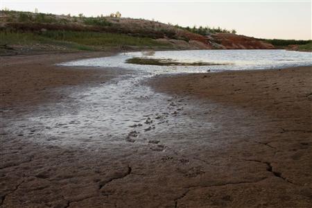
Once a thriving recreational lake and source of water for the town of Robert Lee, Texas, the E.V. Spence Reservoir is now a brackish puddle.
The Daily Impact, November 1, 2011
They are starting to think seriously about abandoning the west Texas town of Robert Lee because it is about to run completely out of water. Too strong? Okay, some of Robert Lee’s 1,049 people are thinking about leaving before the water runs out. Will that create a trend that gives us our first American town to be abandoned because of climate change? (I’m still betting on Las Vegas as the first city.) Will America’s first recognized climate refugees be Rick Perry’s Texans? We’ll report. You decide.
A half-century ago, Robert Lee did what most municipalities in the West did to make sure they would have a permanent water supply: they dammed the Colorado River and made a private lake. (That’s what Vegas did, with a dam called Hoover.) Robert Lee’s lake was the E.V. Spence Reservoir, which gave the town not only water but a tourist industry: marinas and boatyards and lake houses and all the ancillary businesses and revenue flows that derive from people playing on water. In a desert.
Too strong? Robert Lee’s annual rainfall average is 12 inches, which is 2 inches a year above the commonly used standard of 10 inches for a true desert. Twelve inches puts it in the loose category (10-30 inches per year) of semi-arid steppe. In the past year it has received 6 inches of rain. It’s a desert now.
And the E.V. Spence Reservoir, that once covered 22 square miles, more than 20 times the area of the town it nourished, is now more than 99% gone. It’s a fetid pond, now being overrun, in a cinematic post-apocalyptic touch, by herds of feral hogs. The town’s public water is a brown, smelly brine. The marina’s docks loom over bone-dry, crusted ground and the luxurious lake houses overlook, well, desert. And here’s another post-apocalyptic scene: the last green grass in town — which has for two years prohibited lawn-watering — is on the golf course, which uses reclaimed waste water to maintain the emerald green.
But wait! The town has a plan! To build an emergency water pipeline to…wait for it…another town 12 miles way, that has some wells. Two questions:
- Why would that town, which is also located in a desert, in a state suffering its worst drought in recorded history, with no end in sight, pipe a bunch of its last water to Robert Lee? And
- Why on earth would Rick Perry’s Texas, home of the mythical Texas Miracle where people create jobs without government help of any kind and never pay taxes, and where there is no such thing as climate change, cough up the $9 million that Robert Lee needs for its pipeline? (And that the Obama campaign may need as an example of how things really work in Texas.)
Remember the famous question in Jared Diamond’s Collapse: What was on the mind of the man who cut down the last tree on Easter Island (completing the reduction of a one-lush landscape to basically a bare rock)? Well, we can be pretty sure that the two questions above will be on the minds of the person who turns out the last light and leaves Robert Lee, Texas.
Not, one hopes, to go live in Las Vegas.


 Posts
Posts





