by Joe Romm, Climate Progress, January 31, 2014
Scientists have long predicted that climate change would bring on ever-worsening droughts, especially in semi-arid regions like the U.S. Southwest. As climatologist James Hansen, who co-authored one of the earliest studies on this subject back in 1990, told me this week, “Increasingly intense droughts in California, all of the Southwest, and even into the Midwest have everything to do with human-made climate change.”
Scientists have long predicted that climate change would bring on ever-worsening droughts, especially in semi-arid regions like the U.S. Southwest. As climatologist James Hansen, who co-authored one of the earliest studies on this subject back in 1990, told me this week, “Increasingly intense droughts in California, all of the Southwest, and even into the Midwest have everything to do with human-made climate change.”
Why does it matter if climate change is playing a role in the Western drought? As one top researcher on the climate-drought link reconfirmed with me this week, “The U.S. may never again return to the relatively wet conditions experienced from 1977 to 1999.” If his and other projections are correct, then there may be no greater tasks facing humanity than (1) working to slash carbon pollution and avoid the worst climate impact scenarios and (2) figuring out how to feed nine billion people by mid-century in a Dust-Bowl-ifying world.
Remarkably, climate scientists specifically predicted a decade ago that Arctic ice loss would bring on worse droughts in the West, especially California. As it turns out, Arctic ice loss has been much faster than the researchers — and indeed all climate modelers — expected.
And, of course, California is now in the death-grip of a brutal, record-breaking drought, driven by the very change in the jet stream that scientists had anticipated. Is this just an amazing coincidence — or were the scientists right? And what would that mean for the future? Building on my post from last summer, I talked to the lead researcher and several other of the world’s leading climatologists and drought experts.

First, a little background. Climate change makes Western droughts longer and stronger and more frequent in several ways, as I discussed in my 2011 literature review in the journal Nature:
Precipitation patterns are expected to shift, expanding the dry subtropics. What precipitation there is will probably come in extreme deluges, resulting in runoff rather than drought alleviation. Warming causes greater evaporation and, once the ground is dry, the Sun’s energy goes into baking the soil, leading to a further increase in air temperature. That is why, for instance, so many temperature records were set for the United States in the 1930s Dust Bowl; and why, in 2011, drought-stricken Texas saw the hottest summer ever recorded for a US state. Finally, many regions are expected to see earlier snowmelt, so less water will be stored on mountain tops for the summer dry season.
I labeled this synergy Dust-Bowlification. The West has gotten hotter thanks to global warming, and that alone is problematic for California.
“The extra heat from the increase in heat trapping gases in the atmosphere over six months is equivalent to running a small microwave oven at full power for about half an hour over every square foot of the land under the drought,” climatologist Kevin Trenberth explained to me via email, during a drought. “No wonder wild fires have increased! So climate change undoubtedly affects the intensity and duration of drought, and it has consequences. California must be very vigilant with regard to wild fires as the spring arrives.”
And then we have the observed earlier snow melt, which matters in the West because it robs the region of a reservoir needed for the summer dry season — see “US Geological Survey (2011): Global Warming Drives Rockies Snowpack Loss Unrivaled in 800 Years, Threatens Western Water Supply” and “USGS (2013): Warmer Springs Causing Loss Of Snow Cover Throughout The Rocky Mountains.”
As climatologist and water expert Peter Gleick noted to me, quite separate from the impact of climate change on precipitation, “look at the temperature patterns here, which are leading to a greater ratio of rain-to-snow, faster melting of snow, and greater evaporation. Those changes alone make any drought more intense.”
But what of the possibility that climate change is actually contributing to the reduction in rainfall? After all, as Daniel Swain has noted, “calendar year 2013 was the driest on record in California’s 119 year formal record, and likely the driest since at least the Gold Rush era.”
Trenberth explained that, according to climate models, “some areas are more likely to get drier including the SW: In part this relates a bit to the “wet get wetter and dry get drier” syndrome, so the subtropics are more apt to become drier. It also relates to the expansion and poleward shift of the tropics.”
Back in 2005, I first heard climatologist Jonathan Overpeck discuss evidence that temperature and annual precipitation had started to head in opposite directions in the U.S. Southwest, which raises the question of whether we are at the “dawn of the super-interglacial drought.” Overpeck, a leading drought expert at the University of Arizona, warned “climate change seldom occurs gradually.”
In a major 2008 USGS report, Abrupt Climate Change, the Bush Administration (!) warned:
“In the Southwest, for example, the models project a permanent drying by the mid-21st century that reaches the level of aridity seen in historical droughts, and a quarter of the projections may reach this level of aridity much earlier.”
“In the Southwest, for example, the models project a permanent drying by the mid-21st century that reaches the level of aridity seen in historical droughts, and a quarter of the projections may reach this level of aridity much earlier.”
In 2011 US Senate testimony, Overpeck stated:
There is broad agreement in the climate science research community that the Southwest, including New Mexico, will very likely continue to warm. There is also a strong consensus that the same region will become drier and increasingly snow-free with time, particularly in the winter and spring. Climate science also suggests that the warmer atmosphere will lead to more frequent and more severe (drier) droughts in the future. All of the above changes have already started, in large part driven by human-caused climate change.
Overpeck told me this week, “because I think the science only gets stronger with time, I’ll stick to my statements that you quote.” He added, “what’s going on in the Southwest is what anthropogenic global warming looks like for the region.”
Beyond the expansion and drying of the subtropics predicted by climate models, some climatologists have found in their research evidence that the stunning decline in Arctic sea ice would also drive western drought — by shifting storm tracks.
“Given the very large reductions in Arctic sea ice, and the heat escaping from the Arctic ocean into the overlying atmosphere, it would be surprising if the retreat in Arctic sea ice did *not* modify the large-scale circulation of the atmosphere in some way,” Michael Mann, director of the Earth System Science Center at Pennsylvania State University, told me this week. “We now have a healthy body of research, ranging from Lisa Sloan’s and Jacob Sewall’s work a decade ago, to Francis’s more recent work, suggesting that we may indeed be seeing already this now in the form of more persistent anomalies in temperature, rainfall, and drought in North America.”

Back in 2004, Lisa Sloan, professor of Earth sciences at UC Santa Cruz, and her graduate student Jacob Sewall published an article in Geophysical Research Letters, “Disappearing Arctic sea ice reduces available water in the American west” (subs. req’d).
As the news release at the time explained, they “used powerful computers running a global climate model developed by the National Center for Atmospheric Research (NCAR) to simulate the effects of reduced Arctic sea ice.” And “their most striking finding was a significant reduction in rain and snowfall in the American West.”
“Where the sea ice is reduced, heat transfer from the ocean warms the atmosphere, resulting in a rising column of relatively warm air,” Sewall said. “The shift in storm tracks over North America was linked to the formation of these columns of warmer air over areas of reduced sea ice in the Greenland Sea and a few other locations.”
Last year, I contacted Sloan to ask her if she thought there was a connection between the staggering loss of Arctic sea ice and the brutal drought gripping the West, as her research predicted. She wrote, “Yes, sadly, I think we were correct in our findings, and it will only be worse with Arctic sea ice diminishing quickly.”
This week, Sewall wrote me that “both the pattern and even the magnitude of the anomaly looks very similar to what the models predicted in the 2005 study (see Fig. 3a).” Here is what Sewall’s model predicted in his 2005 paper, “Precipitation Shifts over Western North America as a Result of Declining Arctic Sea Ice Cover”:

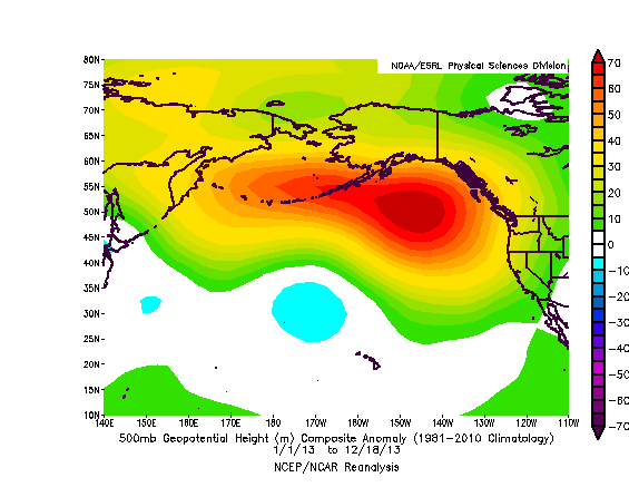
“Geopotential height” is basically the height above mean sea level for a given pressure level. The “500-mb level is often referred to as the steering level as most weather systems and precipitation follow the winds at this level…. This level averages around 18,000 feet above sea level and is roughly half-way up through the weather producing part of the atmosphere called the troposphere.”
Now here is what the 500-mb geopotential height anomaly looked like over the last year, via NOAA:
Look familiar? That is either an accurate prediction or one heck of a coincidence. The San Jose Mercury News described what was happening in layman’s terms:
… meteorologists have fixed their attention on the scientific phenomenon they say is to blame for the emerging drought: a vast zone of high pressure in the atmosphere off the West Coast, nearly four miles high and 2,000 miles long, so stubborn that one researcher [Swain] has dubbed it the “Ridiculously Resilient Ridge.”Like a brick wall, the mass of high pressure air has been blocking Pacific winter storms from coming ashore in California, deflecting them up into Alaska and British Columbia, even delivering rain and cold weather to the East Coast.
This high pressure ridge is forcing the jet stream along a much more northerly track. Sewall told me that multiple factors are driving drought in California:

There are, of course, caveats. This is one year, the model studies were looking at averages of multiple decades (20 or 50 years). There are other factors besides the Arctic ice that influence storm tracks; some preliminary work suggests that a strong El Nino overwhelms any influence of the ice. In El Nino “neutral” times (such as recently), the ice impact can have more of an effect.And for this year, it looks like ice may well be having more of an effect. The geopotential height anomaly looks very much like what the models predicted as sea ice declined. The storm track response also looks very similar with correspondingly similar impacts on precipitation (reduced rainfall in CA, increased precipitation in SE Alaska). While other factors play an influence, the similarity of these patterns certainly suggests that we shouldn’t discount warming climate and declining Arctic sea ice as culprits in the CA drought.
NOAA and Prof. Jennifer Francis of Rutgers have more recently shown that the loss of Arctic ice is boosting the chances of extreme US weather.
Francis told me this week that “the highly amplified pattern that the jet stream has been in since early December is certainly playing a role in the CA drought.”
“The extremely strong ridge over Alaska has been very persistent and has caused record warmth and unprecedented winter rains in parts of AK while preventing Pacific storms from delivering rain to CA,” she explained. “But is this pattern a result of human-caused climate change, or more specifically, to rapid Arctic warming and the dramatic losses of sea ice? It’s very difficult to pin any specific weather event on climate change, but this extremely distorted and persistent jet stream pattern is an excellent example of what we expect to occur more frequently as Arctic ice continues to melt.”
While there is no doubt that climate change is making droughts more intense, the specific connection the loss of Arctic ice is emerging science, and some, like Trenberth, are skeptical that the case has been made.
Whether or not there is a proven link to the loss of Arctic ice, Senior Weather Channel meteorologist (and former skeptic) Stu Ostro has been documenting “large magnitude ridges in the mid-upper level geopotential height field” lasting as long as many months that “have been conspicuous in the meteorology of extreme weather phenomena.”
Ostro gave a talk last year (with Francis), and as Climate Desk summarized, “Ostro’s observations suggest that global warming is increasing the atmosphere’s thickness, leading to stronger and more persistent ridges of high pressure, which in turn are a key to temperature, rainfall, and snowfall extremes and topsy-turvy weather patterns like we’ve had in recent years.”
The climate is changing. “All of our weather is now, and increasingly in the future, influenced by climate change,” Gleick wrote me. “The question about attribution (i.e., is this drought caused by climate change) is, of course, the wrong question — easy for deniers to dismiss because it is not easy to show unambiguous links to some kinds of individual events.”
What is especially worrisome is that climate change has only just started to have an impact on Western droughts. We’ve only warmed 1.5 °F in the past century. Absent strong climate action, we are on track to warm 10 °F over the next century!
We continue to dawdle even though scientists have been warning us of what was coming for decades. Hansen himself co-authored a 1990 study, “Potential evapotranspiration and the likelihood of future drought,” which projected that severe to extreme drought in the United States, then occurring every 20 years or so, could become an every-other-year phenomenon by mid-century.
So we should listen to Hansen’s current warnings. In 2012 he warned in the NY Times of a return to Dust Bowls, writing, “over the next several decades, the Western United States and the semi-arid region from North Dakota to Texas will develop semi-permanent drought … California’s Central Valley could no longer be irrigated. Food prices would rise to unprecedented levels.”
Hansen repeated those concerns in an email to me this week, noting that the current drought “will break, of course, likely with the upcoming El Nino, but as long as we keep increasing greenhouse gases, intense droughts will increase, especially in the Southwest. Rainfall, when and where it comes will tend to be in more intense events, with more extreme flooding. These are not speculations, the science is clear.”
How long can these droughts last? They have lasted for decades in the distant past, and one 2010 study warned that we could see “an unprecedented combination” of multi-decade droughts “with even warmer temperatures.”
Drought researcher Aiguo Dai was quoted in a 2012 NCAR news release for a 2012 study warning, “The U.S. may never again return to the relatively wet conditions experienced from 1977 to 1999.”
This week I asked him, “Do you still stand by that statement?” He replied:
Yes, I still stand by that statement. The model projections have not changed. To the extent we can trust the CMIP [Coupled Model Intercomparison Project] model projections, I still think the U.S. will experience increased risk of drought in the coming decades. What has been happening during recent years in the central and western U.S. is very consistent to what I have been predicting: both the natural variability (IPO [Interdecadal Pacific Oscillation]) and human-induced climate change will increase the risk of drought over these regions for the next 1-2 decades. After that, the IPO may switch to a positive phase that normally would bring more rain over the U.S. regions, but by that time the human-induced warming have over-dominate the natural variability, with the U.S. regions still in drier conditions (compared with the 1980s-1990s).
Finally, a 2009 NOAA-led paper warned that, for the Southwest and many semi-arid regions around the world, “the climate change that is taking place because of increases in carbon dioxide concentration is largely irreversible for 1,000 years after emissions stop.” Impacts that should be expected if we don’t aggressively slash carbon pollution “are irreversible dry-season rainfall reductions in several regions comparable to those of the ‘dust bowl’ era.”
When the climate changes, it ain’t gonna change back.


 Posts
Posts