Blog Archive

Showing posts with label GrIS. Show all posts

Sunday, May 29, 2022

Historic Greenland ice sheet rainfall unraveled

by , May 26, 2022

Historic Greenland ice sheet rainfall unravelled
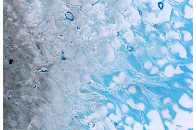
Meltwater and surface lakes on the Greenland ice sheet. Credit: contains modified Copernicus Sentinel data (2021), processed by ESA

For the first time ever recorded, in the late summer of 2021, rain fell on the high central region of the Greenland ice sheet. This extraordinary event was followed by the surface snow and ice melting rapidly. Researchers now understand exactly what went on in those fateful summer days and what we can learn from it.

The never-before-seen rainfall, on 14 August 2021, made headlines around the world. The upper-most parts of Greenland's enormous ice cap used to be too cold for anything other than  to fall, but not anymore.

What caused this extreme rainfall and how did it affect the ice?

Researchers from the Department of Glaciology and Climate at the Geological Survey of Denmark and Greenland (GEUS) in collaboration with colleagues from France and Switzerland have scrutinized these questions and come up with the answers.

It didn't only rain at Summit Camp—rain was measured by new automatic weather stations placed across the ice sheet by GEUS' ice-sheet monitoring projects PROMICE and GC-Net.

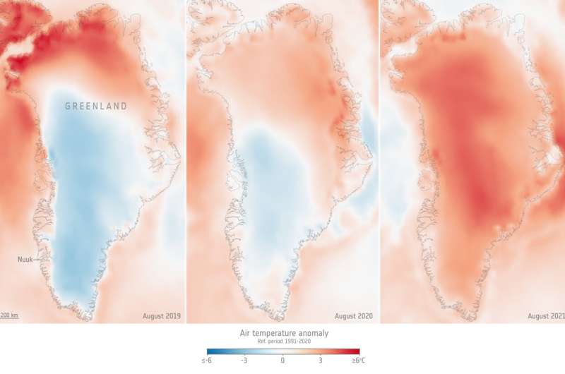
Studying detailed data from these stations alongside measurements of surface reflectivity, or albedo, from the Copernicus Sentinel-3  and information on , the researchers discovered that the rain had been preceded by a heatwave at a time of year when seasonal melting is usually slowing down.
Historic Greenland ice sheet rainfall unravelled
Greenland air temperature for August 2019, 2020, 2021, compared to the 1991–2020 August average. Credit: Copernicus Climate Change Service/ECMWF/ESA (data ERA5)

It wasn't the rain

"It turns out that the rain itself wasn't the most important factor," says Prof. Jason Box from GEUS and lead author of the paper reporting their results, which has been accepted for publication in Geophysical Research Letters.

"There is an irony. It's not really the rain that did the damage to the snow and ice, it's the darkening effect of the meltwater and how the heat from the event erased snow that had overlaid darker ice across the lower third of the ice sheet.

"Unusually warm atmospheric rivers swept along Greenland in the late summer months, bringing potent melt conditions when the  was drawing to a close."

In fact, this sudden increase of surface ice melt on Greenland could have happened without any rain ever touching the ground.

The never-before-seen rainfall, on 14 August 2021, made headlines around the world. The upper-most parts of Greenland's enormous ice cap used to be too cold for anything other than  to fall, but not anymore.


For the first time ever recorded, in the late summer of 2021, rain fell on the high central area of the Greenland ice sheet. This extraordinary event was preceded by a heatwave and followed by the surface snow and ice rapidly melting. The animation is a series of five images captured by the Copernicus Sentinel-2 mission and shows how the surface of the ice sheet changed between on 1, 3, 5, 20, and 23 August 2021. The melt, which also created lakes on the surface of the ice, is clear to see. Researchers, supported by ESA’s Science for Society program, discovered that it wasn’t actually the rain that caused the melt, it was unusually warm ‘atmospheric rivers’ that swept along Greenland, bringing potent melt conditions when the melt season would normally be drawing to a close. Credit: contains modified Copernicus Sentinel data (2021), processed by ESA.

Even though the rainfall was a shock and a milestone in climate history, researchers knew it was bound to happen sooner or later, given the rising temperatures of the Arctic.

Therefore, Prof. Box and the co-authors encourage research to look further into the workings behind atmospheric rivers and not just rainfall.

They conclude that understanding the frequency of heatwaves, appears to be a more significant research target than the liquid precipitation that heatwaves may or may not produce.


https://phys.org/news/2022-05-historic-greenland-ice-sheet-rainfall.html

Sunday, April 21, 2019

WaPo: It’s been exceptionally warm in Greenland lately and ice is melting a month early


Warmth over Greenland is highlighted in a daily analysis from mid-April. (ClimateReanalyzer.org)

by Matthew Cappucci, The Capital Weather Gang, The Washington Post, April 18, 2019

You might have heard about the exceptional heat this year in the northern hemisphere and around the world. March was just declared the second warmest on record globally
Records have been shattered in AlaskaScotland hit 70 degrees in February. Winter warmth has torched the U.K., The Netherlands, and Sweden as well — coming on the heels of Europe’s warmest year on record. But they’re not alone.
Greenland is baking, too. In fact, its summer melt season has already begun — more than a month ahead of schedule.
Marco Tedesco is a professor in atmospheric sciences at the Lamont Doherty Earth Observatory of Columbia University. He monitors behavior of the cryosphere — the part of earth’s water system that is frozen. He says melting of this extent shouldn’t begin until May. “The first melt event was detected on April 7,” he wrote in email.
Greenland melt extent in 2019, compared to normal. (National Snow and Ice Data Center)
“Air temperature anomalies were up to more than 20 degrees Celsius [36 Fahrenheit] above the mean,” noted Tedesco. His team has been eyeing Greenland’s southeast coast as ground zero for the early-season thaw. “Surface air temperature jumped to 41 degrees on April 2, up from minus-11,” he said. Temperatures dropped below freezing briefly before again soaring into the 30s, where the mercury has held steady for most of the past week.
What’s been sling-shotting this balmy air northward?

“The subtropical jet stream,” wrote Jennifer Francis, senior scientist at the Woods Hole Research Center in Falmouth, Mass. It’s teamed up with the polar jet to “transport warm, moist air from near Florida northward into southern Greenland,” she explained. “Locking this pattern in place has been a strong ridge — a northward bulge in the jet stream — just east of Greenland.”
A lack of ice cover in the Arctic Ocean north of Scandinavia gave this bubble of warmth a bit of an extra boost, intensifying its warm conveyor belt into Greenland.
Going forward, “[t]hese types of patterns are expected to occur more frequently,” Francis wrote, citing climate change as the culprit. “Arctic ice cover continues to dwindle and temperatures there soar.”
But advection — the transport of air, in this case warm, from somewhere else — is just half the battle. Adding insult to injury is a shortage of cloud cover in recent weeks over Greenland. The high pressure “block” that Francis described has also helped clear the skies, allowing more sunshine to pour in and heat the ground further.
A reanalysis showing precipitation also points to where the source of warmth in Greenland is coming from. (ClimateReanalyzer.org)
“Incoming solar radiation reached a value similar to ones we observed in August last year,” wrote Tedesco. That heats the ground even more. It’s a vicious cycle of positive feedback, indicating just how unstable — and delicate — the Arctic is.
“I call this ‘melting cannibalism,” explained Tedesco. And it could get even worse, as it preconditions the ice to be more vulnerable to melting in the summer.
When snow/ice on the ground melt, they form small pools of water. That changes how reflective the surface is — a measure scientists refer to as “albedo.” Snow and ice have a very high albedo, meaning it reflects most of the incoming light that hits it. That’s why you have to wear sunglasses when you go skiing. Water, on the other hand, is a lot less shiny, which allows it to absorb more heat, a cyclical process on a local level and a driver of additional warming on the global level.
According to the National Snow and Ice Data Center, the rate of melting this early in the year has been off the charts. Satellite imagery shows several patches of extremely early melt along the coast.
And it’s not just Greenland. Much of the Arctic has been baking. Ice melt in Alaska has set rivers gushing more than a month before normal in some places, setting records along the Kuskokwim River in Bethel, and triggering the earliest ice breakup along the Tanana River in Nenana.
https://www.washingtonpost.com/weather/2019/04/18/its-been-exceptionally-warm-greenland-lately-ice-is-melting-month-early/

Tuesday, April 2, 2019

Ice-cliff failure via retrogressive slumping doi.org/10.1130/G45880.1

Geology, (2019) ; https://doi.org/10.1130/G45880.1

Ice-cliff failure via retrogressive slumping


Abstract

Retrogressive slumping could accelerate sea-level rise if ice-sheet retreat generates ice cliffs much taller than observed today. The tallest ice cliffs, which extend roughly 100 m above sea level, calve only after ice-flow processes thin the ice to near flotation. Above some ice-cliff height limit, the stress state in ice will satisfy the material-failure criterion, resulting in faster brittle failure. New terrestrial radar data from Helheim Glacier, Greenland, suggest that taller sub-aerial cliffs are prone to failure by slumping, unloading submarine ice to allow buoyancy-driven full-thickness calving. FullStokes diagnostic modeling shows that the threshold cliff height for slumping is likely slightly above 100 m in many cases and roughly twice that (145–285 m) in mechanically competent ice under well-drained or low-melt conditions.


https://pubs.geoscienceworld.org/gsa/geology/article/569567/ice-cliff-failure-via-retrogressive-slumping

Friday, July 1, 2016

M. A. Cooper et al., GRL (2016), Paleofluvial landscape inheritance for Jakobshavn Isbræ catchment, Greenland

Please go to the link to the full, open-access article for the amazing figures showing the ancient river beds under the ice sheet:

http://onlinelibrary.wiley.com/doi/10.1002/2016GL069458/full

Geophysical Research Letters,  (21 June 2016); doi10.1002/2016GL069458

Paleofluvial landscape inheritance for Jakobshavn Isbræ catchment, Greenland

M. A. Cooper*, K. Michaelides, M. J. Siegert and J. L. Bamber

Abstract

Subglacial topography exerts strong controls on glacier dynamics, influencing the orientation and velocity of ice flow, as well as modulating the distribution of basal waters and sediment. Bed geometry can also provide a long-term record of geomorphic processes, allowing insight into landscape evolution, the origin of which may predate ice sheet inception. Here we present evidence from ice-penetrating radar data for a large dendritic drainage network, radiating inland from Jakobshavn Isbræ, Greenland's largest outlet glacier. The size of the drainage basin is ∼450,000 km2 and accounts for about 20% of the total land area of Greenland. Topographic and basin morphometric analyses of an isostatically uplifted (ice-free) bedrock topography suggests that this catchment predates ice sheet initiation and has likely been instrumental in controlling the location and form of the Jakobshavn ice stream, and ice flow from the deep interior to the margin, now and over several glacial cycles.


A 3.5-million-year-old river network preserved beneath the Greenland Ice Sheet

An ancient drainage basin covering one fifth of Greenland predates the ice sheet and strongly influences the modern Jakobshavn Glacier, according to a new analysis of ice-penetrating radar data.

SOURCE: Geophysical Research Letters
by Terri Cook, EOS.org,
Using detailed geophysical surveys of Greenland and Antarctica conducted during the past few decades, scientists can now peer below the thick glacial ice to learn more about the origin and evolution of the underlying landscape. To date, most of these studies of subglacial topography have focused on Antarctica. Now Cooper et al. have turned their attention to Greenland, where they have discovered the first evidence of an extensive network of rivers in the landscape beneath the Jakobshavn Isbræ, the island’s largest outlet glacier.
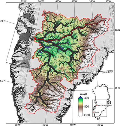
Using a digital elevation model generated from ice-penetrating radar data and corrected for the weight of the modern ice sheet, the team charted the ancient river network using two different software packages. The results of both tools reveal a dendritic network of valleys radiating inland from the Jakobshavn Glacier —a landscape that, according to the researchers, covers an area comparable in size to the Ohio River Basin and predates the formation of the ice sheet about 3.5 million years ago.
Ancient river network beneath Jakobshavn Glacier.
The ancient river network underneath Jakobshavn Isbræ basin is shown in black; a main stream of the catchment is marked by the solid red line. Bed elevation (between 300 and 1,300 meters above sea level) is also shown. Credit: Cooper et al., 2016.
The team’s analysis reveals a watershed that is mostly smooth and low in elevation but also includes mountainous terrain on its eastern edge, for a total elevation range of 3,382 meters. Within this basin, the team discovered very large channels up to 1,400 meters deep and 12 kilometers wide—dimensions that exceed the recently reported north Greenland “megacanyon.” Their findings of low valley width-to-depth ratios, V-shaped channel cross sections, and a main channel elevation profile typical of river networks all support the conclusion that extended river incision, rather than glacial erosion, was the dominant process that formed this network.
Assuming a steady rate of incision into the hard, underlying gneiss, the researchers estimate that it would have taken about 2.3 million years to carve the observed channels, although they acknowledge that processes like glacial outbursts or increased discharge during interglacial periods could have shaped them over much shorter periods of time.
Near the basin outlet, the researchers also observed an abrupt break in slope at the confluence of three ancient channels. This knickpoint coincides with the location where the surface flow of the Jakobshavn Glacier rapidly accelerates, a finding that suggests that the underlying, preglacial landscape exerts a strong influence on the location, shape, and size of Greenland’s largest outlet glacier. 
(Geophysical Research Lettersdoi:10.1002/2016GL069458, 2016)
—Terri Cook, Freelance Writer
Citation: Cook, T. (2016). A river network preserved beneath the Greenland ice sheet, Eos, 97, doi: 10.1029/2016EO054839. Published on 28 June 2016.

Sunday, November 22, 2015

Extraordinary runoff from the Greenland Ice Sheet in 2012 amplified by hypsometry and depleted firn-retention by A. B. Mikkelson et al., The Cryosphere Discuss., 9 (2015) 4625-4660; doi: 10.5194/tcd-9-4625-2015

The Cryosphere Discuss., 9 (2015) 4625-4660; doi: 10.5194/tcd-9-4625-2015

Extraordinary runoff from the Greenland Ice Sheet in 2012 amplified by hypsometry and depleted firn-retention

A. B. Mikkelsen1,2, A. Hubbard3,4, M. MacFerrin5, J. Box6, S. Doyle4, A. Fitzpatrick4, B. Hasholt1, and H. Bailey4
1Department of Geosciences and Natural Resource Management, University of Copenhagen, Copenhagen, Denmark
2Centre for Permafrost (CENPERM), University of Copenhagen, Øster Voldgade 10, Copenhagen, 1350, Denmark
3Centre for Arctic Gas Hydrate, Environment and Climate, Department of Geology, University of Tromsø, Dramsveien 201, 9037, Norway
4Department of Geography and Earth Sciences, Aberystwyth University, Aberystwyth, SY23 3DB, UK
5Cooperative Institute for Research in Environmental Sciences (CIRES), University of Colorado, Boulder, CO, USA
6Department of Marine Geology and Glaciology, Geological Survey of Denmark and Greenland, Copenhagen, Denmark

Abstract


It has been argued that the infiltration and retention of meltwater within firn across the percolation zone of the Greenland ice sheet has the potential to buffer up to ~3.6 mm of global sea level rise (Harper et al., 2012). Despite evidence confirming active refreezing processes above the equilibrium line, their impact on runoff and proglacial discharge has yet to be assessed. Here we compare meteorological, melt, firn-stratigraphy and discharge data from the extreme 2010 and 2012 summers to determine the relationship between atmospheric forcing and runoff across the Kangerlussuaq catchment of the Greenland ice sheet, which drains into Watson River. The bulk discharge in 2012 of 6.8 km3 exceeded that of 2010 of 5.3 km3 by 28%, despite only a 3% difference in net energy available for melt between the two summers. This large disparity in discharge response can be explained by a 24% contribution of runoff originating from above the long-term equilibrium line in 2012, triggered by diminished firn retention that culminated in three days of record discharge from 11 July of 3,100 m3 s−1 (0.27 km3 d−1) that washed-out the Kangerlussuaq bridge. 


Throughout the 2010 melt-season, there was a steady increase in the residual difference between integrated melt over the catchment and cumulative proglacial discharge that by mid-September equated to 21% (~1.1 km3) of the total melt generated being retained within the catchment. In 2012, a similar pattern is observed until 11 July, after which the residual fell by 50% and further diminished so that less than 0.4 km3 (~5 %) of the total melt was retained by the end of the summer. Cumulative energy receipts versus bulk discharge further indicate a marked contrast between the two melt seasons, such that in 2012 there was a notably higher discharge response per unit energy forcing after the 11 July. 


Density profiles from cores and pits within the accumulation area acquired in April 2012 reveal an extensive, dense, ice-layer between 0.9 to 1.4 m snow depth that extended from the equilibrium line to at least 1,840 m elevation. This perched superimposed ice layer can be attributed to melt refreezing during previous summers and we hypothesize that in July 2012, it provided a barrier to further infiltration rendering the underlying pore space inaccessible thereby forcing extensive runoff from the accumulation zone. Discharge was further amplified by catchment hypsometry, leading to a disproportionate increase in the area contributing to runoff as the melt-level rose above the ice sheet plateau in July 2012. Satellite imagery and oblique aerial photographs confirm an active network of supraglacial rivers extending 140 km from the ice margin providing strong support for the hypothesis. 


Our findings substantiate active infiltration processes across the percolation zone of the Greenland ice sheet, though the resulting patterns of refreezing are complex and can lead to spatially extensive, perched, superimposed layers within the firn. In 2012, such layers extended to 1,840 m, providing a low-permeable obstruction to further meltwater storage, thereby promoting runoff into the hydrological system that contributed directly to sea-level rise.


Citation: Mikkelsen, A. B., Hubbard, A., MacFerrin, M., Box, J., Doyle, S., Fitzpatrick, A., Hasholt, B., and Bailey, H.: Extraordinary runoff from the Greenland Ice Sheet in 2012 amplified by hypsometry and depleted firn-retention, The Cryosphere Discuss., 9 (2015) 4625-4660; doi:10.5194/tcd-9-4625-2015.

http://www.the-cryosphere-discuss.net/9/4625/2015/tcd-9-4625-2015.html