Remarkable Hurricane Sandra exploded into a Category 4 storm with 145-mph winds overnight, making it the latest major hurricane ever observed in the Western Hemisphere (November 26). The previous record was held by an unnamed Atlantic hurricane in 1934 that held on to Category 3 status until 00 UTC November 24. Sandra is also now the latest Category 4 storm ever observed in either the Eastern Pacific (previous record: Hurricane Kenneth on November 22, 2011) or the Atlantic (previous record: "Wrong Way" Lenny on November 18, 1999). Prior to Sandra, the strongest East Pacific hurricane so late in the year was 1983’s Winnie, which topped out on December 6 at 90-mph winds. Sandra is the first major hurricane in the Western Hemisphere that has ever been observed on Thanksgiving Day. According to WU contributor Phil Klotzbach (Colorado State University), Sandra is on track to become the latest landfalling tropical cyclone on record for Mexico, beating out Tara (November 12, 1961). An Air Force Hurricane Hunter mission is scheduled for Sandra on Friday afternoon.
Figure 1. VIIRS infrared satellite image of Hurricane Sandra taken at 3:15 p.m. EST, November 25, 2015. At the time, Sandra was a Category 3 storm with 115-mph winds. Image credit: Dan Lindsey, NOAA/CIRA.
Figure 2. Latest satellite image of Sandra.
A rare Thanksgiving Day hurricane
Sandra is only the second Thanksgiving Day hurricane in modern records for the Atlantic or Eastern Pacific, and the strongest by far. The other hurricane was Hurricane Karl of 1980, which spun harmlessly as a minimal Category 1 hurricane far out in the central North Atlantic on Thanksgiving Day that year. Several other weaker storms have had NHC forecasters issuing advisories on Thanksgiving Day. This includes 1987’s Tropical Storm Keith, which struck Florida as a tropical storm on Wednesday, November 23, and persisted as a strong tropical storm east of Florida until midday Thanksgiving Day (November 24). In 1998, minimal Tropical Storm Nicole weakened to a depression east of Bermuda early on Thanksgiving Day (November 26), with advisories discontinued at 10 a.m. EST. Nicole did get a new lease on life several days later, becoming a hurricane on November 30 and persisting to become one of just five Atlantic hurricanes on record during the month of December. In the hyperactive Atlantic season of 2005, Tropical Storm Delta roamed the eastern Atlantic on Thanksgiving Day (November 24). And in 2011, a weakening Tropical Storm Keith well out to sea in the eastern Pacific prompted advisories on Thanksgiving Day (November 24). Prior to the establishment of NHC as we know it, an unnamed tropical storm dissipated on Thanksgiving Day 1953 (November 26) well east of Bermuda. Hawaii takes the cake for the worst U.S. hurricane-related impacts during Thanksgiving Week: Hurricane Iwa passed near Kauai on Tuesday, November 23, 1982, during the run-up to the “super” El Niño of 1982-83. Iwa caused one death and inflicted $250 million in damage in Kauai.
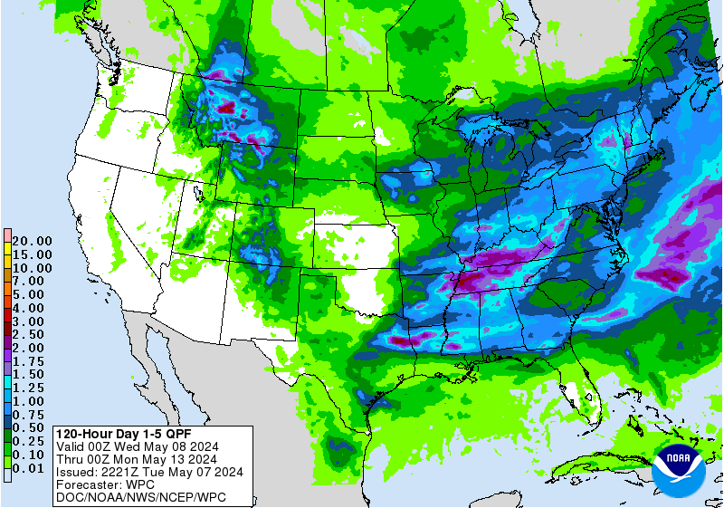
Figure 3. Projected 5-day precipitation totals (rain and melted snow/sleet) for the period from 7 a.m. EST Thursday, November 26, through Tuesday, December 1.
Thanksgiving travel troubles in store across the Central U.S.
Some of the biggest impacts from Sandra may occur with a prolonged heavy rain episode in the Southern Plains, increased by Sandra’s remnants. The strong upper-level low settling over the U.S. Southwest will help pull Sandra northeastward, and the storm’s moisture will flow atop a very shallow cold air mass that will spill across the Southern Plains later this week. Such setups involving Eastern Pacific hurricanes are notorious for giving the region some of its heaviest rains on record, but they are far more typical of September or October than late November.
Flash flood watches are already in effect from far north Texas to southwest Illinois, and localized flooding may become a major travel headache. Rainfall totals of 5-10” are expected from Thursday through Monday across north Texas, southeast Oklahoma, and much of Arkansas. These rains will fall over areas that have been doused repeatedly over the last few months. With 50.75” of rain for the year through Wednesday, the Dallas-Fort Worth area may well break its all-time annual precipitation record of 53.54” (set in 1991), before November is done.
On the northwest edge of the heavy rain swath, there will be a parallel strip with low-level temperatures cold enough for widespread freezing rain, sleet, and/or snow, from Thanksgiving Day into Friday. An ice storm warning has been issued for parts of Texas, Oklahoma, and Kansas, with some places expected to get 0.5-1.0" of ice.
Stay safe, everyone, and have a great Thanksgiving!
Jeff Masters and Bob Henson
http://www.wunderground.com/blog/JeffMasters/an-unprecedented-thanksgiving-visitor-a-category-4-hurricane


No comments:
Post a Comment