by Brian Trewin, The Guardian, December 3, 2013

Mean temperatures in September were 2.75C above the average. Photograph: Newspix/Rex Features
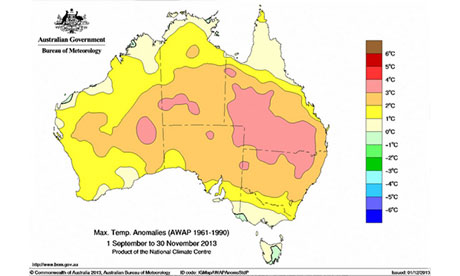
The spring of 2013 has been Australia's warmest on record. Mean temperatures for the season were 1.57C above the 1961-1990 average, surpassing the previous record of 1.43C (set in 2006) by 0.14C. Daytime maximum temperatures were also the highest on record, coming in 2.07C above average and 0.24C above the previous record (also set in 2006), while overnight minimum temperatures were the fourth-warmest on record.
The warmth was most dramatic in September, which saw a mean temperature anomaly of +2.75C, setting a new monthly record by more than a degree. October was also a very warm month, 1.43C above average. Temperatures during November were closer to normal, 0.52C above average, but were still warm enough to complete a record spring.
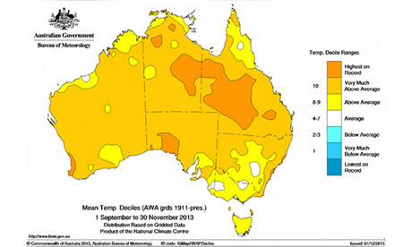
The warmth was extensive, with virtually the entire country experiencing above-average mean temperatures for the spring. It was the warmest spring on record over an area covering most of western Queensland (sufficient to give Queensland its warmest spring on record), and extending into the eastern interior of the Northern Territory.
Records were also set on the west coast around Perth, on the east coast around Sydney, and on parts of the Nullarbor. The spring ranked in the 10 warmest on record over 83% of the country.
Strong westerly winds were a feature of the prevailing weather over southern parts of the continent during September and October. This brought unusually wet weather to western Tasmania, southwest Victoria, and southwest Western Australia — regions that are exposed to maritime westerlies.
 Dark orange shows areas where mean temperatures in spring 2013 were the highest on record. Source: Australian Bureau of Meteorology
Conversely, the same general westerly airflow brought persistently dry and hot weather to inland regions across the southeast. These conditions, combined with a record warm winter and little rainfall since July, saw significant early season fire activity in central eastern NSW in September and October.
The low soil moisture in some parts of the southeast also contributed to unusually large daily temperature ranges during October. Maximum temperatures were well above average but minimum temperatures were below average. An early start to the growing season combined with late frosts caused major crop losses in southern New South Wales and northern Victoria on 18 October.
October was also notable for heat in the northern tropics.Fitzroy Crossing in northern Western Australia reached 40C on each of the first 29 days of the month, an unprecedented sequence at any Australian station this early in the year.
 The map above shows the number of degrees mean maximum temperatures were above/below normal. Source: Australian Bureau of Meteorology
The pattern of westerlies broke down around the end of October, and most of November was dominated by easterly flow. This brought moist conditions (and frequent severe thunderstorms) to the east coast. Easterly flow off the continent brought consistently hot conditions to western parts of Western Australia, where many locations had their hottest November on record.
It was a rather cool November in the southeast, particularly in Tasmania and southern Victoria, but was not far enough below average to offset the very warm September, except in a few parts of Tasmania. In central Sydney average maximum temperatures for November were cooler than those for September, something which has only happened once before, in 1998.
Another feature of the spring was unusually heavy early-season rain in the northern tropics. In a normal year, November sees scattered thunderstorms across regions such as the Kimberley and the Top End. Widespread heavy rain, however, does not normally develop until the monsoon becomes established in December or January. In 2013, general rains developed during the second half of November (including with unusually early landfalling tropical cyclone, Alessia). Spring rainfall was above average through most of the far north and approached record levels in a few places.
The record warm spring leaves Australia on track to have its warmest calendar year on record. Mean temperatures for Australia for the 11 months ending in November were 1.23C above average and 0.18C above the previous record year, 2005.
The three-month climate outlook for December 2013 to February 2014 favours wetter-than-average conditions across much of Western Australia, western Victoria and Tasmania, and dry and warm conditions along much of the east coast of Australia.
• Blair Trewin is a climatologist at the National Climate Centre at the Australian Bureau of Meteorology. This piece was originally published in The Conversation.


No comments:
Post a Comment