On March 15, 2013, Arctic sea ice extent appears to have reached its annual maximum extent, marking the beginning of the sea ice melt season. This year’s maximum extent was the sixth lowest in the satellite record. NSIDC will release a detailed analysis of the 2012 to 2013 winter sea ice conditions in early April.
Overview of conditions

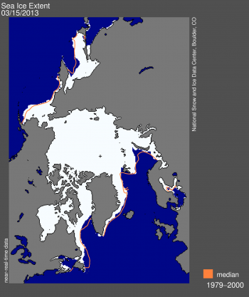
Figure 1. Arctic sea ice extent on March 15 was 15.13 million square kilometers (5.84 million square miles). The orange line shows the 1979-2000 median extent for that day. The black cross indicates the geographic North Pole. Sea Ice Index data. About the data.
Credit: National Snow and Ice Data Center. High-resolution image
Credit: National Snow and Ice Data Center. High-resolution image
On March 15, 2013, Arctic sea ice likely reached its maximum extent for the year, at 15.13 million square kilometers (5.84 million square miles). The maximum extent was 733,000 square kilometers (283,000 square miles) below the 1979-2000 average of 15.86 million square kilometers (6.12 million square miles). The maximum occurred five days later than the 1979-2000 average date of March 10. The date of the maximum has varied considerably over the years, with the earliest maximum in the satellite record occurring as early as February 24 in 1996 and as late as April 2 in 2010.
This year’s maximum ice extent was the sixth lowest in the satellite record. The lowest maximum extent occurred in 2011. The ten lowest maximums in the satellite record have occurred in the last ten years, 2004 to 2013.
Conditions in context

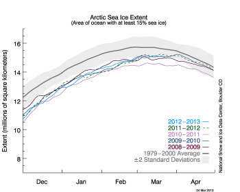
Figure 2. The graph above shows Arctic sea ice extent as of March 24, 2013, along with daily ice extent data for the previous five years. 2012-2013 is shown in blue, 2011-2012 in green, 2010-2011 in pink, 2009-2010 in navy, and 2008-2009 in purple. The 1979-2000 average is in dark gray. The gray area around this average line shows the two standard deviation range of the data. Sea Ice Index data. Credit: National Snow and Ice Data Center. High-resolution image.
Over the 2012-2013 winter season, sea ice extent grew a record 11.72 million square kilometers (4.53 million square miles). The record growth was primarily a result of the record low minimum last September, leaving a greater extent of ocean surface uncovered in ice to re-freeze this winter. This seasonal ice gain is 645,000 square kilometers (249,000 square miles) higher than the previous record (2007-2008) and 2.63 million square kilometer (1.02 million square miles) higher than the 1979-2000 average. Last autumn’s record low and this winter’s record ice growth indicate a more pronounced seasonal cycle in Arctic sea ice and the increasing dominance of first-year ice in the Arctic.
Final analysis pending
At the beginning of April, NSIDC scientists will release a full analysis of winter conditions, along with monthly data for March. For more information about the maximum extent and what it means, see the NSIDC Icelights post, the Arctic sea ice maximum. For previous analyses, please see the drop-down menu under Archives in the right navigation at the top of this page.


No comments:
Post a Comment