State of the Climate
National Overview
April 2011
National Oceanic and Atmospheric Administration
National Climatic Data Center
Use the form below to access monthly reports.
Maps and Graphics
Temperature and Precipitation Ranks
U.S. Percentage Areas
More Information
National Overview:
The weather pattern over the contiguous United States during April 2011 consisted of a westerly flow with strong low pressure waves or troughs embedded in the flow. Some of the troughs formed deep low pressure systems with slow moving cold fronts which generated heavy rain and severe weather, especially in the Midwest to Southeast. According to preliminary reports, April had 875 reports of tornadoes which caused over 350 deaths. The National Weather Service expected the confirmed tornado count to exceed 600, which is a record for any month. There were over 2,000 preliminary reports of hail damage and more than 3,200 wind damage reports, with most of the damage occurring from the southern and central Plains to the Atlantic coast. Tornadoes were observed on two-thirds of the days of the month, with the biggest tornado outbreaks reported on the 14th-16th and 25th-27th.
A zonal storm track was associated with the westerly flow, effectively dividing the country into above-normal precipitation across much of the northern half and below-normal rainfall across the southern tier. By the end of the month, wet soils dominated the northern U.S. and dry soils much of the southern U.S., where intensifying drought and widespread wildfires plagued the southern Plains. Texas had the 5th driest April in the 117-year record. The storm track repeatedly tapped Gulf of Mexico moisture in a southerly surface airflow that generated storm systems week after week over the Midwest. The resulting well-above-normal rainfall culminated in widespread record flooding in the Ohio Valley by the end of the month. Some areas received up to 20 inches of rain during the month, which is nearly half their normal annual precipitation. Six states (Illinois, Indiana, Kentucky, Ohio, Pennsylvania, and West Virginia) had their wettest Aprils on record. Snow cover was confined to the northern areas and mountainous West. Snow cover peaked on April 20 when 22% of the contiguous U.S. was snow covered, but the month ended with only 10% coverage. Based on monthly average snow cover extent, April 2011 ranked as the 8th snowiest April in the 45-year satellite record for the contiguous U.S., and 10th snowiest April for North America.
April temperatures averaged below normal across the northwestern half of the country and above normal from the southern Plains to the Northeast, reflecting a westerly circulation that extended further south -- but was stronger -- than normal. The three states in the Pacific Northwest (Washington, 2nd coldest; Oregon 5th; Idaho, 10th) had the 10th coldest, or colder, April, while 9 states in the South and East ranked in the top 10 warmest category, with Delaware claiming its warmest April on record. This temperature pattern reflected a storm system orientation that contributed to the stormy weather east of the Rockies. On a national scale, April 2011 ranked as the 39th warmest and 10th wettest April in the 1895-2011 record.
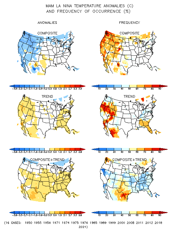
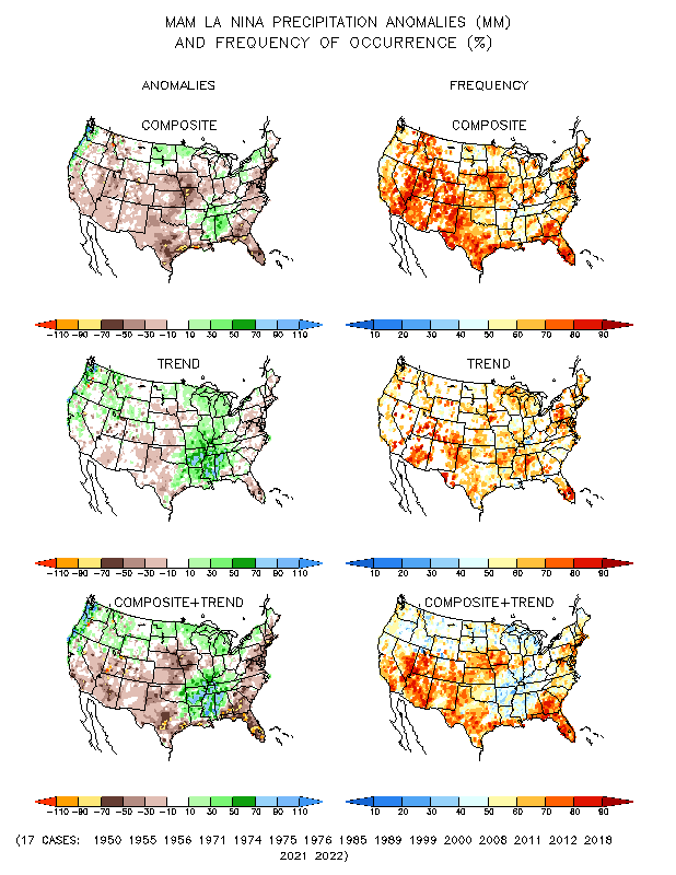
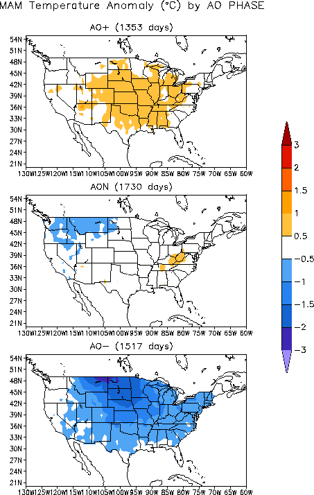
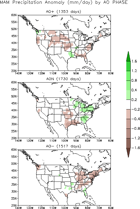
Cold fronts and low pressure systems moving in the storm track flow are influenced by the broadscale atmospheric circulation. Four such large-scale atmospheric circulation patterns were dominant during April. The first was a weakening La Niña, which is the phenomenon created by cooler-than-average sea surface temperatures in the eastern tropical Pacific Ocean. At this time of year, La Niña is typically associated with cold temperature anomalies in the Northwest, warm anomalies in the South, and dry anomalies across most of the country. The second atmospheric circulation index was the Pacific/North American (PNA) pattern, which was negative for most of the month. A negative PNA this time of year is typically associated with warmer-than-normal temperatures over the southeast third of the U.S. and colder-than-normal temperatures in the Northwest. Precipitation is not strongly correlated. The third atmospheric circulation index was the North Atlantic Oscillation (NAO) pattern, which waspositive for most of the month. A positive NAO this time of year is typically associated with warmer-than-normal temperatures across most of the country and drier-than-normal conditions in the Southeast and parts of the central and western U.S. The fourth atmospheric circulation index was the Arctic Oscillation (AO) pattern, which was alsopositive for most of the month. A positive AO this time of year is typically associated with warmer-than-normal temperaturesacross the central U.S. and drier-than-normal conditions across parts of the central and southeastern U.S.
The pattern of observed temperature anomalies for April 2011 generally matched the La Niña and PNA patterns for April (mid-spring), with some correlation to the NAO and AO patterns. The April precipitation pattern generally matched the mid-spring La Niña, NAO, and AO patterns in the southern Plains and Southeast. But the above-normal precipitation pattern for April 2011 in the Midwest and Northwest is closer to the mid-winter instead of mid-spring La Niña, PNA, and AO patterns.
- Climate Highlights - April
- The average U.S. temperature in April was 52.9 °F (11.6 °C), which is 0.9 °F (0.5 °C) above the long-term (1901-2000) average. April precipitation was 0.7 inch (18 mm) above the long-term average, the 10th wettest such month in 117 years of data.
- April was a month of historic climate extremes across much of the United States, including: record breaking precipitation that resulted in historic flooding; recurrent violent weather systems that broke records for tornado and severe weather outbreaks; and wildfire activity that scorched more than twice the area of any April this century.
- The Central climate region had its wettest April on record and it was the second wettest for the Northeast. Illinois, Indiana, Kentucky, Ohio, West Virginia, and Pennsylvania each had their wettest April since records began in 1895. An average of 11.88 inches (302 mm) of precipitation fell across Kentucky — nearly three times its long-term average — breaking the Commonwealth's previous record (7.61 inches or 193 mm, in 1972) by more than four inches (102 mm).
- In Texas, drought intensified, as the state had its fifth driest April on record. The Lone Star State has not experienced above-average precipitation since September 2010. Based on the U.S. Drought Monitor, 94% of the state is classified as in Severe drought (called the D2 category) to Exceptional drought (D4, the most intense designation).
- Nationally, the overall drought footprint across the contiguous U.S. remained above average, but decreased slightly from the beginning of the month to about 22%. The area of the country affected by the two most intense drought categories (D3, Extreme and D4, Exceptional) has increased for ten consecutive weeks, a streak dating to mid-February. Much of this very intense drought is focused in the Southern Plains and Southern Rockies.
- Ideal wildfire conditions prevailed across portions of the Southern Plains during April, and a record breaking 1.79 million acres burned across the country during the month. Texas, where over 2.2 million acres have burned since January, again bore the brunt of the wildfire activity.
- Several violent tornado outbreaks affected the country during April. According to data from NOAA's Storm Prediction Center, the number of confirmed tornadoes for the month may approach the previous all time monthly record of 542 tornadoes which struck the U.S. in May 2003.
- Much of the southern and eastern U.S. experienced above-normal warmth in April. Based on preliminary data, Delaware had its warmest such month since records began in 1895. It was the fourth warmest April for Virginia and the fifth warmest for Texas. Other states with much above normal warmth include Florida and Louisiana (7th warmest), New Mexico and West Virginia (8th), New Jersey (9th) and Maryland (10th).
- The Northwest was much cooler-than-normal during April. Washington (2nd coolest),Oregon (5th coolest) and Idaho (10th coolest) were all much cooler than normal. Washington had the greatest negative anomaly, 5 °F below their long-term average.
Much more at this link: http://www.ncdc.noaa.gov/sotc/national/2011/4


No comments:
Post a Comment