Lessons learned from winter of 2010-2011
by Stu Ostro, The Weather Channel, February 14, 2011
[Dear Readers, Sorry about the lousy formatting. Please go to the link at the bottom for original article.]
With a much-needed break from this wild winter finally being experienced, here's a reflection on the remarkable season so far. This expounds upon quotes from me in a recent USA Today article.
- La Nina & El Nino are not the be-all and end-all of everything.

I've written about this topic on more than one occasion in the past, and have included that classic cartoon.
I can't find the link now, but at one point this winter I saw an article online which basically attributed everything happening weatherwise everywhere on the planet exclusively to La Nina.
It doesn't work like that. La Nina and El Nino are important influences upon the atmosphere, directly in areas near the equatorial Pacific and indirectly in some other regions. However, they aren't the only game in town, especially as one gets farther from the source and in areas where other weather/climate factors are just as if not more important.
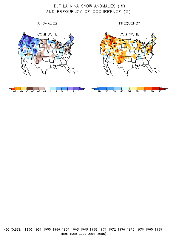
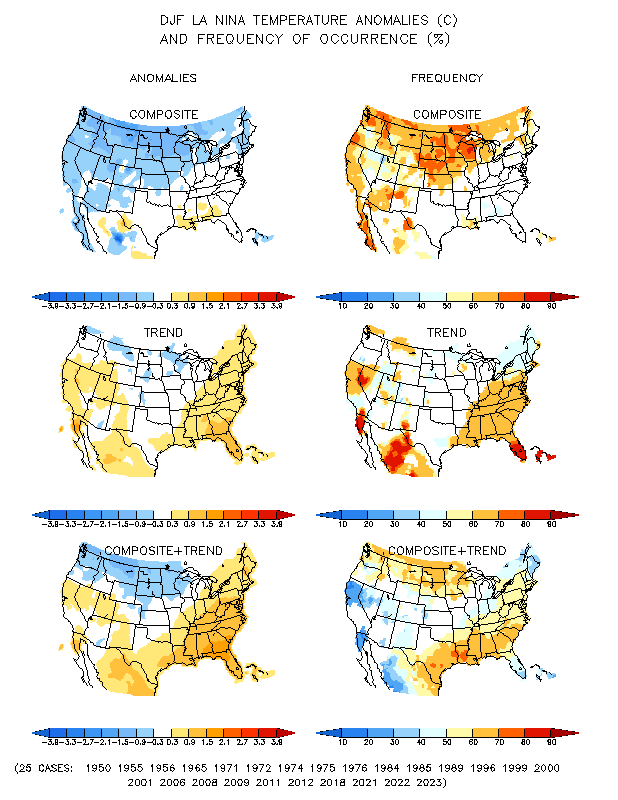
This winter some of those other factors at times overwhelmed the influence of La Nina, which historically on average has resulted in below-average snowfall from Oklahoma to New Jersey and above-average temperatures in the Southeast.
- Ridges rule.
During winter in North America, especially the central and eastern part, the extent to which there are strong "blocking" ridges of high pressure aloft in high latitudes is crucially important for the details of temperatures and storminess.
Both last winter, when there was a strong El Nino present (above-average sea surface temperatures in the central-eastern equatorial Pacific Ocean), and this season, with a strong La Nina (the opposite, i.e. below average SSTs), potent and persistent ridges of high pressure aloft were an important player.
As I said in the USA Today interview, I wish the NAO were as much of a household term as El Nino and La Nina have become! Many of those strong blocking ridges were directly associated with a consistently and strongly "negative" phase of phenomena known as the NAO (North Atlantic Oscillation) and AO (Arctic Oscillation; nowadays the term "Northern Annular Mode" or NAM, is increasingly being used instead of the NAO/AO).
Whatever the acronym, and there are others such as the PNA (Pacific - North American pattern), what's important is what they represent: the configuration of high pressure ridges and low pressure troughs, of dips and bulges in the jet stream.
A couple of those ridges aloft -- one over Greenland in December, and another over Alaska in January -- set records for how strong they were for the combo of the time of year and so far north.
The graphics below vividly illustrate the predominant pattern during the period when most of this season's wildness occurred, starting in late November in Europe and continuing into early February in the United States.
The top one shows the departure from average pressures aloft (technically, "500 millibar heights"). You don't need to be a meteorologist to be able to see that there's a dramatic signal!
This represents averages across the span of a couple of months -- the pressure pattern wasn't like that every day -- but a configuration of strong high-latitude ridges and feisty troughs of low pressure to the south occurred repeatedly.
The bottom graphic depicts preliminary data for departure from average surface temperatures. While London and Paris and Atlanta were shivering from cold and digging out from snow, and that got a lot of attention due to them being big population and media centers, a much different picture is painted across Greenland and the northeast half of Canada.
(Different map projections, which don't stretch regions in high latitudes, are available here; even on them, the anomalies from Greenland across northeast Canada, and also extending to near Alaska, stick out like a sore thumb.)


- A key area of scientific research recently has been, and ought to continue to be, connections between reduced arctic sea ice and current / potential future changes in atmospheric circulation patterns.
Those ridges, i.e., the weather pattern at times this season, may have been influenced by the record low Arctic sea ice extent in December and January, and we need to focus on further understanding the nature of the processes involved.
Prior to this winter, I was intrigued about the possibility, but a little, uh, skeptical about the degree (no pun intended) of influence that had occurred so far. Now I am convinced that the loss of sea ice is having a significant effect upon weather not only locally but also downstream.
This graph, which shows how much more slowly Hudson Bay froze over this season (the bottom, solid line) than in other years, is particularly stunning. When I first saw it, I did a double-take.

[Click on image for full-sized version.]
The amount and details of the influence vary, as the Earth-atmosphere system is very complex and there is always natural variability also at play at all time scales, but it's illogical to think that the extra heat being released directly into the atmosphere overhead is not having any effect.
- Global warming and extreme snowfall are not mutually exclusive.
In fact, as I have been documenting for years, there is evidence that the former is playing a role in the latter (and in unusual cold events), by way of those ridges of high pressure.
Also, the recent extraordinary extremes in precipitation are consistent with there being increased moisture in a warmer global atmosphere. Yet, more moisture alone is not enough to explain the details of what's happening in the day-to-day weather outcomes; that's where the atmospheric circulation (those ridges, etc.) comes into play along with changes in stability, as processes are required to focus and lift the water vapor and turn it into historic amounts of precipitation that have been frequently occurring lately, in the form of both rainfall and snowfall, such as has happened yet again in recent days (this time snow in South Korea).
- Beware of snowstorm overachievement
On a number of occasions, storms this winter "overachieved," producing peak snowfall amounts in given locations greater than what was generally expected by computer models and human forecasters. Perhaps how much that occurred this winter is related to an increased tendency for precipitation extremes.
Whether or not that's the case, what happened over and over again reinforces how important small-scale details are within the larger-scale snow system -- things such as "mesoscale banding" which sets up and persists over the same locations -- and the need to consider the potential for such outcomes when communicating forecast information, and then be closely monitoring the evolution of the snowfall rates and pattern when the storms get underway. The latest example was the narrow swath of extreme snowfall in northeast Oklahoma and northwest Arkansas on February 8-9, 2011.
- Regardless of how/if changes in climate played a role this winter, our vulnerability to extreme weather has been demonstrated yet again
Just as the 2004 and 2005 hurricane seasons exposed that vulnerability, especially along the Gulf Coast and in Florida (and other years have also done that in this country and elsewhere), this season has dramatically illustrated, in both the U.S. and Europe, how vulnerable we are to severe winter conditions, and raised issues of preparedness.
Examples include a massive impact upon air/road travel; particular traffic fiascos in Chicago, Washington, D.C., Cleveland, Buffalo, and Atlanta; fatalities from vehicular accidents and shoveling heavy, wet snow; many roof collapses in the Northeast, and of the Metrodome; widespread power outages; extended school closings; problems leading up to the Super Bowl; and perceived lack of snow-removal response, and subsequent political heat for mayors in New York City, Chicago, and Atlanta.
It's not just tropical cyclones, tornadoes, floods, and heat that greatly affect us. Whether those, or blizzards and ice storms, or sunshine and tranquility, every aspect of weather is important to our lives.

AP Photo/Kiichiro Sato. Hundreds of cars are seen stranded on Lake Shore Drive, Wednesday, February 2, 2011, in Chicago.


No comments:
Post a Comment