From the National Snow and Ice Data Center, August 26, 2008
Sea ice extent has fallen below the 2005 minimum, previously the second-lowest extent recorded since the dawn of the satellite era. Will 2008 also break the standing record low, set in 2007? We will know in the next several weeks, when the melt season comes to a close. The bottom line, however, is that the strong negative trend in summertime ice extent characterizing the past decade continues.
Note: The NSIDC will issue an an update with finalized numbers tomorrow morning.

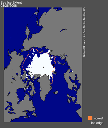
Figure 1. Daily Arctic sea ice extent for August 25, 2008, fell below the 2005 minimum, which was 5.32 million square kilometers (2.05 million square miles). The orange line shows the 1979 to 2000 average extent for that day. The black cross indicates the geographic North Pole. Sea Ice Index data. About the data. —Credit: National Snow and Ice Data Center.
Overview of conditions
With several weeks left in the melt season, sea ice extent dipped below the 2005 minimum to stand as the second-lowest in the satellite record. The 2005 minimum, at 5.32 million square kilometers (2.05 million square miles), held the record-low minimum until last year.
Recent ice retreat primarily reflects melt in the Chukchi Sea off the Alaskan coast and the East Siberian Seas off the coast of eastern Russia.
Note: The NSIDC will issue an update with finalized numbers tomorrow morning.
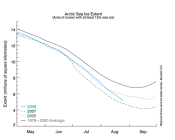
 Figure 2. The graph above shows daily sea ice extent.The dashed blue line indicates 2008; the dark blue dotted line indicates 2005; the dotted green line shows extent for 2007; the gray line indicates average extent from 1979 to 2000. Sea Ice Index data. —Credit: National Snow and Ice Data Center.
High-resolution image
Conditions in context
Through the beginning of the melt season in May until early August, daily ice extent for 2008 closely tracked the values for 2005.
In early August of 2005, the decline began to slow; in August of 2008, the decline has remained steadily downward at a brisk pace. The 2005 minimum of 5.32 million square kilometers (2.05 million square miles) occurred on September 21.
Link: http://nsidc.org/arcticseaicenews/


No comments:
Post a Comment