Taiwan is bracing for the arrival of Typhoon Dujuan, which will tear across the northern part of the island on Monday night local time. Dujuan intensified rapidly over the weekend, growing from Category 1 to Category 4 strength in just 36 hours. As of 1200 GMT (8 am EDT) Sunday, Dujuan was packing winds of 145 mph, just short of supertyphoon levels. Dujuan has an annular structure, with a huge eye--more than 50 miles in diameter--and cyclonic banding limited to its south side. Sea-surface temperatures will continue above average and wind shear will remain very light (below 10 knots) along the remainder of Dujuan’s approach to Taiwan. Annular hurricanes are often relatively slow to weaken, which lends further support to the idea of Dujuan maintaining most or all of its current strength before it reaches Taiwan. The path projected by the Joint Typhoon Warning Center on Sunday morning has Dujuan onshore as a Category 3 typhoon at 1200 GMT (8 pm Taiwan time) on Monday night, with Taipei on the dangerous right-hand side of the typhoon.
Figure 1. Infrared image from NASA’s VIIRS instrument of Typhoon Dujuan, taken at 0510Z (1:10 am EDT) on Sunday, September 27, 2015. Image credit: NOAA/NASA RAMMB/CIRA, courtesy Dan Lindsey.
Figure 2. MODIS image of Typhoon Dujuan approaching Taiwan as seen from NASA's Terra satellite on Sunday, September 27, 2015. Image credit: NASA.
Taiwan is vulnerable to large damages from typhoons
Taiwan and its capital city of Taipei are very vulnerable to large damages from typhoons. A September 2015 "City Risk Index" developed by Lloyds of London rated Taipei the most financially exposed city in the world to disasters, due to the wealth of the city and its exposure to disasters such as typhoons, earthquakes, floods, and volcanoes. The top risk factor: typhoons, which can potentially put $81 billion in assets at risk in the city. Taiwan has already been hit by one major typhoon this year--Typhoon Soudelor, which hit Taiwan as a Category 3 storm with 120 mph winds on August 8, killing 8 people and doing over $30 million in damage. More than 4 million power customers lost power in Taiwan; according to taipower.com, this is Taiwan's largest power outage ever caused by a typhoon. Torrential rain also impacted northern Taiwan; Datong Township, Yilan County, reported 52.52 inches of rain from Soudelor. Taiwan's most damaging typhoon was Super Typhoon Herb of July 1996. Herb hit the island as a Category 4 storm with 150 mph winds, passed directly over the capital of Taipei, and did $1.1 billion in damage.
Figure 3. A basketball court is flooded by the Jingmei River as Typhoon Soudelor hits Taipei, Taiwan on Aug. 8, 2015. (Sam Yeh/AFP/Getty Images)
Rains from Tropical Storm Niala to douse Hawaii
East- and south-facing slopes of Hawaii’s Big Island may get widespread rainfall of 2” – 8” and localized totals of 12” or more today through Monday as Tropical Storm Niala moves south of the state. As of 11 am EDT Monday, the exposed low-level center of Niala was located about 245 miles south-southeast of Hilo, moving west-southwest as 7 mph. The Tropical Storm Watch formerly in effect for Hawaii has been discontinued. Tropical storm force winds only extent up to 80 miles from the center, so high winds will not be a threat, but the lighter winds and rich moisture assocaited with Niala’s broader circulation will enhance the normal trade-wind flow that makes the east slopes of Hawaii’s volcanic peaks among the wettest places on the planet. The Big Island remains in a flash flood watch through Monday, with already-saturated ground increasing the risk of flash flooding. Niala’s top winds are just 50 mph, and southwesterly wind shear of more than 30 knots should weaken the storm to depression strength by late Monday or Tuesday as it angles to the southwest of Hawaii.
Figure 4. MODIS image of Tropical Storm Niala approaching Hawaii as seen from NASA's Aqua satellite on Saturday, September 26, 2015, at approximately 4 pm EDT. At the time, Niala had top winds of 65 mph, but its low-level center had become exposed to view due to high wind shear. Image credit: NASA.
Widespread rains in store for Gulf Coast
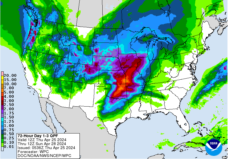
A broad area of surface low pressure sprawled across the western Gulf of Mexico, dubbed Invest 99L, will bring several days of scattered heavy rain from southeast Texas to much of Florida. The entire system is being steered by a nearly stationary upper low now centered along the Texas coast. The small low-level center of circulation of 99L is just north of the Yucatan peninsula, with another area of surface low pressure and concentrated showers and thunderstorms close to the Louisiana coast associated with the upper low. Southwesterly wind shear from the upper low should inhibit the multiple surface centers from consolidating into a tropical storm. However, a subtropical-type system may emerge, with numerous bands and clusters of convection sweeping into the Southeast from the Gulf Coast through Tuesday. An Air Force reconnaissance plane is on standby for a possible mission into 99L later Sunday, and NHC gives the system a 30% chance of tropical or subtropical development. The NOAA Weather Prediction Center is projecting widespread 2” – 3” totals along the immediate coast from Houston to Tampa, with lighter amounts further inland (see Figure 5). We can expect similar drenching set-ups to occur periodically through the fall and into the winter, as the powerful El Niño now in place will support a strong subtropical jet stream into the Gulf of Mexico and nearby states. The risk of tornadoes and other severe weather will increase during the winter months over Florida, where El Niño significantly boosts the odds of wintertime tornadoes.
Figure 5. Forecast rainfall amounts from 1200 GMT (8:00 am EDT) Sunday, September 27, through Wednesday, September 30. Image credit: NOAA/NWS Weather Prediction Center.
Tropical Storm Marty pondering a Mexican landfall
The future of Tropical Storm Marty is shrouded in an unusually high amount of uncertainty. Marty’s sustained winds had risen to 60 mph at 11 am EDT Sunday, with the center about 235 miles southwest of Acapulco. Very warm sea-surface temperatures of 30-31°C (86-88°F) are helping keep Marty’s convection robust despite moderate southwesterly wind shear (about 20 knots) as the storm inches northward at just 7 mph. The operational GFS model and most of the GFS ensemble members continue to bring Marty north and northeastward into the Mexican coast not far from Acapulco, while several ensemble members shunt Marty to the northwest, avoiding landfall. The ECMWF and UKMET models also take a weaker Marty northwestward and keep it offshore. None of the major models intensify Marty beyond minimal hurricane strength. Given the track uncertainty, NHC may issue a Tropical Storm Watch for the Mexican coast later on Sunday. NASA’s WB-57 aircraft is scheduled to release more than 50 dropsondes in and near Marty on Sunday as part of a research mission.
Figure 6. Latest satellite image of Tropical Storm Marty.
Ida clinging to life
Pesky Tropical Depression Ida continues to hang on as an identifiable cyclone in the central Atlantic--but just barely, with little organized convection. Ida is now on the south side of a upper-level ridge that should keep It rolling westward. Dynamical models all keep TD Ida below tropical storm strength throughout the next five days, and interactions with a front to its north may cause Ida to degenerate into a trough or remnant low at any time during the week.
Figure 7. Latest satellite image of Invest 98L.
Invest 98L could become a depression
West of Ida and east of the Bahamas, a gradually organizing area of showers and thunderstorms could become a tropical depression within the next couple of days. The system is passing over record warm ocean temperatures near 30°C (86°F), with wind shear in the moderate range (10 - 20 knots). NHC gives the system a 50% chance of development in the next three days. Wind shear is predicted to rise to the high range, 20 - 30 knots, beginning on Sunday night, which will likely put a cap on 98L’s development.
Figure 8. The total lunar eclipse of October 8, 2014, as photographed in California by Alfredo Garcia, Jr. Image credit: Wikimedia Commons/Tomruen.
It’s super-lunar-eclipse time tonight!
What could be the most spectacular lunar eclipse in decades will unfold tonight, as a “supermoon” coincides with a total lunar eclipse. The last time this happened was in 1982, and it won’t happen again until 2033. Sunday’s lunar eclipse is timed especially well for the Americas, with totality falling between around 7:00 to 8:30 pm PDT and 10:00 to 11:30 pm EDT. Evening skies should be fair or clear over much of the nation outside of the Southeast and the Atlantic coast. For more details, see the conclusion of our post from last Friday. If you can't see the eclipse directly, check out NASA's live feed from the Griffith Observatory in Los Angeles. Happy viewing!
http://www.wunderground.com/blog/JeffMasters/comment.html?entrynum=3127


No comments:
Post a Comment