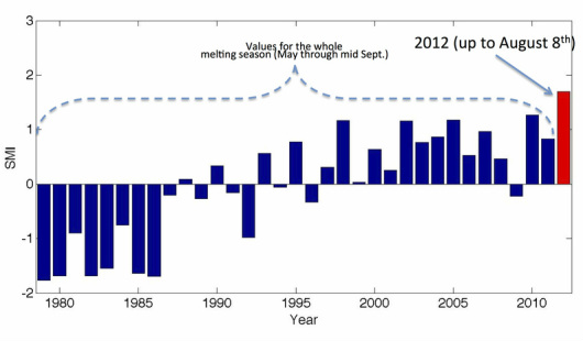
Melting in Greenland set a new record before the end of the melting season. Over the past days, the cumulative melting index over the entire Greenland ice sheet (defined as the number of days when melting occurs times the area subject to melting) on August 8th exceeded the record value recently set in 2010 for the whole melting season (which usually ends around the beginning of or middle of September).

Standardized melting index (SMI) for the period 1979-2012. The years between 1979 and 2011 use the full length season (May through September), where 2012 uses only the available period May through August 8th. Note that the 2012 value is much higher than any of the previous years, despite the shorter period.
The melting index is computed from passive microwave satellite measurements, and it can be viewed as a measure of the ‘strength’ of the melting season: the higher the index the more melting occurred. With more melting yet to come during August, 2012 will position itself way above the old records, likely becoming the 'Goliath' of the melting years during the satellite record (1979 - to date). From the map below, we see that the cumulative melting index record is due to extensive increased melting occurring all over Greenland, especially at high elevations where melting lasted up to 50-60 days longer than the average. This means that some of the areas at high elevations in south Greenland are generally subject to a few days of melting (if it occurs at all), and this year they underwent melting for more than 2 months (so far).
Melting was extreme also in the west, northwest and northeast regions. Along the southwest coast melting does not appear to have been extreme. However, care must be taken in interpreting the passive microwave results over this area. Indeed, the exposure of bare ice might 'blind' the microwave data and preclude them from detecting melting. Extensive bare ice (above the average for 2012 !) has been suggested by model results (e.g., see the link to Xavier Fettweis' MAR results analysis), consistent with a reduced albedo observed by satellite sensors (see post on Jason Box's analysis of MODIS, as well as our papers on the role of albedo in the Scientific Literature section). In 2010, we identified warming surface temperatures, reduced accumulation and albedo reduction (following premature exposure of bare ice) -- some of the major potential drivers for the melting record (see here).

So, how is this record different from the one that occurred in mid-July 2012 and received so much coverage?
The extreme melting detected at high elevations in mid-July (covering ~ 97% of the Greenland ice sheet, see image on the left) generated liquid water that refroze after a few days, changing the physical properties of the snowpack but very likely not contributing to the meltwater that run offs from the ice and can potentially contribute to sea level rise. The event was exceptional in the sense that it is a rare event (imagine a postcard of Rio de Janeiro under a thin layer of snow !), but it has happened in the past, according to the research of colleagues from the Dartmouth College at Summit. The record set by the overall melting has implications on the meltwater that goes into the ocean, and it can impact ice dynamics through basal lubrication or through its impact on the subglacial and englacial drainage systems. Also, the increased melting at higher elevations might remove the seasonal snow and expose more bare ice. The removal of bare ice (which is darker and absorbs more solar radiation and is therefore more prone to melting than snow) is actually contributing to the net mass loss of Greenland. Seasonal snow is indeed part of the annual cycle (water from the ocean goes into the atmosphere which turns into clouds and is released as snow, which melts again and goes back to the ocean) where ice has been sitting there for decades or hundreds (and more) of years, and it is therefore adding new 'material' to the cycle (e.g., the ocean).
The extreme melting detected at high elevations in mid-July (covering ~ 97% of the Greenland ice sheet, see image on the left) generated liquid water that refroze after a few days, changing the physical properties of the snowpack but very likely not contributing to the meltwater that run offs from the ice and can potentially contribute to sea level rise. The event was exceptional in the sense that it is a rare event (imagine a postcard of Rio de Janeiro under a thin layer of snow !), but it has happened in the past, according to the research of colleagues from the Dartmouth College at Summit. The record set by the overall melting has implications on the meltwater that goes into the ocean, and it can impact ice dynamics through basal lubrication or through its impact on the subglacial and englacial drainage systems. Also, the increased melting at higher elevations might remove the seasonal snow and expose more bare ice. The removal of bare ice (which is darker and absorbs more solar radiation and is therefore more prone to melting than snow) is actually contributing to the net mass loss of Greenland. Seasonal snow is indeed part of the annual cycle (water from the ocean goes into the atmosphere which turns into clouds and is released as snow, which melts again and goes back to the ocean) where ice has been sitting there for decades or hundreds (and more) of years, and it is therefore adding new 'material' to the cycle (e.g., the ocean).

An important point to mention is that the passive microwave sensors cannot tell us about the amount of surface mass loss from melting. They can only 'see' when and where melting is occurring, but they become 'blind' when it comes down to estimating how much water was produced from that melting. This is why we use the 'melting index' in order to have an idea of the 'strength' of the melting season. In general, there is a good correspondence between the melting index and the surface mass loss on a seasonal basis. This said, we use models to complement the lack of information from remote sensing tools. Models have their own intrinsic limitations, but they can provide estimates of physical quantities (such as the mass loss). The model we use has been widely tested vs. ground and satellite observations, and we are confident of its results. The preliminary analysis of model outputs (the Mode´le Atmosphe´rique Re´gional, a.k.a. MAR) that we obtained in collaboration with Xavier Fettweis from the University of Liege in Belgium (see link in the Main page, on the right) confirms the extreme melting year for 2012. Modeled results also indicate that the trend for the annual cumulative surface mass balance (SMB) for 2012 (until the end of July) is the minimum since 1958 (the model is run back to 1958, differently from satellite data that is available starting in 1979). The modeled results for the SMB until the end of July is ~ -90 Gt (using January 1st as a starting value at zero Gt). The same values for 2010 over the same period were ~ -60 Gt and about 0 Gt for 2011. The modeled loss just for the month of August (from the end of July to the end of August) in the case of 2010 was ~ -60 Gt, and it was ~ -100 Gt in the case of 2011. So, whether or not the SMB record will be set depends on how things proceed during August. We are currently running the model, and we might have some preliminary results by next week. In general, we are planning to write a paper about this as soon as the season is over, and we will be submitting it by mid-September. However it goes (whether 2012 is going to be a record year or not in terms of SMB), this year will likely be amongst the top years. Less than one month to go to get a response ...
Investigation is currently going on to address some of the causes of the melting record through model results and observations. The analysis of the combined remote sensing data and model outputs is carried out within the framework of a project sponsored by the National Science Foundation to improve estimates of the surface mass balance of the Greenland ice sheet and by the NASA Cryosphere Program to collect data on the ground for the validation of the results. Preliminary analysis indicates above-normal surface temperatures and a reduction of albedo -- the potential major drivers for the new melting record. This is suggested by model results and other satellite observations. Let us see what August is going to reserve for us ...
http://www.greenlandmelting.com/1/post/2012/08/2012-the-goliath-melting-year.html
http://www.greenlandmelting.com/1/post/2012/08/2012-the-goliath-melting-year.html


No comments:
Post a Comment