Freak current takes Gulf Stream to Greenland
by FishOutofWater, DailyKos, January 6, 2010An unprecedented extreme in the northern hemisphere atmospheric circulation has driven a strong direct connecting current between the Gulf Stream and the West Greenland current. The unprecedented negativity of the "Arctic Oscillation" and the strong connection of the Gulf Stream with the Greenland current are exceptional events. More exceptional weather events are predicted with anthropogenic climate change, but this could be a natural variation of weather and currents.
The West Greenland current transports water originating from the Nordic seas that wrap around the southern tip of Greenland.
The West Greenland Current (WGC) flows north along the shelf and shelf break of the west coast of Greenland. It transports about 3 Sv of fresh (salinity < 34.5), cold (-1.8 °C) water from the Nordic seas (Clarke 1984; Cuny et al. 2002).The West Greenland current normally does not connect directly with the Gulf Stream, but the most negative "Arctic oscillation" in 50 years of measurement caused a strong wind field that temporarily drove the Gulf Stream toward the west Greenland current.
Negative phase of the Arctic Oscillation
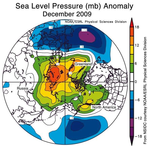
These regional contrasts in temperature anomalies resulted from a strongly negative phase of the Arctic Oscillation (AO). The AO is a natural pattern of climate variability. It consists of opposing patterns of atmospheric pressure between the polar regions and middle latitudes. The positive phase of the AO exists when pressures are lower than normal over the Arctic, and higher than normal in middle latitude. In the negative phase, the opposite is true; pressures are higher than normal over the Arctic and lower than normal in middle latitudes. The negative and positive phases of the AO set up opposing temperature patterns. With the AO in its negative phase this season, the Arctic is warmer than average, while parts of the middle latitudes are colder than normal. The phase of the AO also affects patterns of precipitation, especially over Europe.
The phase of the AO is described in terms of an index value. In December 2009 the AO index value was -3.41, the most negative value since at least 1950, according to data from the NOAA Climate Prediction Center.

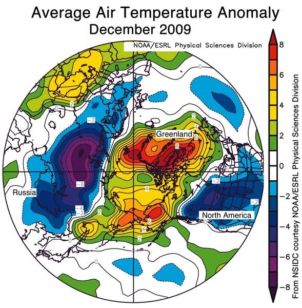
The unprecedented atmospheric circulation pattern brought exceptionally warm air to Greenland and the Arctic ocean while dumping cold Arctic air into the United States, Europe and central Siberia.
Warm air keeps ice extent lowAnomaly in degrees Celsius.
December air temperatures over the Arctic Ocean region, eastern Siberia, and northwestern North America were warmer than normal. In contrast, temperatures in Eurasia, the United States, and southwestern Canada were below average. The strongest anomalies (more than 7 degrees Celsius/13 degrees Fahrenheit) were over the Atlantic side of the Arctic, including Baffin Bay and Davis Strait, where ice extent was below average.

The warm air over the Arctic ocean and Greenland slowed the formation of sea ice. Sea ice in the Labrador Sea decreased in late December with the strong current that brought warm water up the west coast of Greenland.

The past gives clues to what might be happening in the North Atlantic.
Recent research on paleoclimates (10 pg PDF) is showing that very warm Gulf Stream water penetrated much further north in the seas between Greenland and Norway in the Paleocene before the Pleistocene glaciations began.
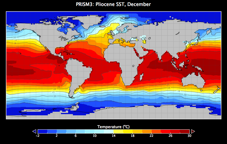
The USGS Pliocene Research, Interpretation and Synoptic Mapping (PRISM) Project is charged with reconstructing global conditions during the ~3.3 to 3.0 Ma time interval (hereafter "the mid-Piacenzian") in an effort to better understand past and possible future climate dynamics. PRISM reconstructions of sea-surface temperature (SST), based largely on planktic foraminifer assemblage data, indicate that temperature differences between the mid-Piacenzian and modern increase with latitude in the North Atlantic (Dowsett et al. 1992). That is, mid-Piacenzian temperatures near the equator were similar to modern temperatures, but temperatures in the higher latitudes were several degrees warmer than at present. This reconstructed equator-to-pole gradient has been indeterminate at and above ~66° N, however, because temperature estimates from polar regions such as the Nordic Seas and Arctic Ocean have remained elusive due to the lack of geologic proxies yielding quantitative results as well as weak age control.

Water off of Spitzbergen was 65 °F in August. Northern Europe had a much warmer climate.
Summer temperatures between 10 °C and 18 °C and very low BFARs imply at least seasonally ice-free conditions in the subpolar North Atlantic and nearby Arctic Ocean during the mid-Piacenzian. Incorporation of these data into the PRISM SST reconstruction provides a possible analog to future climate. (The benthic foraminifer accumulation rate (BFAR), is calculated as the number of dead benthic foraminifer specimens in 10 cc of sediment. In the modern Arctic, the BFAR is lowest under seasonally ice-free areas and highest under permanent ice cover at any given water depth (Wollenberg and Kuhnt 2000).)Paleoclimates were more sensitive to CO2 than previously recognized according to new research studies of CO2 in soil. The warmest paleoclimates happened at CO2 levels of 1000 ppm -- where we are headed if there are no limits on fossil fuel emissions. The soil research showed that paleo -- CO2 levels were calculated based on average conditions when soil carbonate actually forms under the hottest and driest conditions. This miscalculation caused ancient CO2 levels to be overestimated for warm periods like the Mesozoic and the Paleocene.
The carbon isotope compositions of modern soil and speleothem carbonate were studied in the southwestern USA in order to investigate their relationship to local plant cover. Our results suggest that δ13C values of both soil and speleothem carbonate tend to be biased toward seasonal extremes rather than "average" plant distributions. Evidence from modern soils in central New Mexico indicates that soil carbonate forms during the warmest and driest times of year. Reduced respiration rates under these conditions lower soil CO2 concentrations and help drive the precipitation of calcite. Soil carbonates are biased toward C4 plants because they record the annual maximum δ13C values of soil CO2 that occur during dry episodes. In addition, if pedogenic carbonate records minimum rather than mean growing season soil pCO2 values, then paleoatmopsheric CO2 concentrations calculated using the paleosol barometer may be significantly overestimated.The need for urgent action to rapidly cut emissions of CO2, other greenhouse gases, and black carbon soot is becoming more evident by the day.
Link: http://www.dailykos.com/story/2010/1/6/822520/-Freak-Current-Takes-Gulf-Stream-to-Greenland


No comments:
Post a Comment