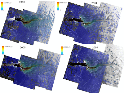
Jakobshavn Glacier, Greenland: 2000, 2004, 2005, and 2006 velocitiesoverview
BPRC Remote Sensing Lab
Jakobshavn Glacier (click on image to enlarge), Greenland's largest glacier, drains approximately 6.5% of the ice sheet and is a key factor in the mass balance of the Greenland Ice Sheet. Although the interior of the ice sheet is in a state of balance, the coastal region has continued to thin. While there has been variability in the velocity of Jakobshavn over time the ice front has steadily retreated. It wasn't until the year 2000 that an increase in ice flow velocities was recorded and an increasing trend observed.
Interferometric pairs are used to compute ice sheet surface velocities for the years 2000, 2004, 2005, and 2006 during the approximate months of November through early January of the following year. The methodology and results discussed in this report are provided in partial fulfillment of OSU's agreement to provide remote sensing data to the Center for Remote Sensing of Ice Sheets (CReSIS) CRESIS Home Page science requirements. CReSIS's vision is to advance understanding of polar ice sheets sufficiently for the development of models that reliably predict future ice sheet contributions to sea level rise under prescribed changes in climate.
This web page contains documentation and procedures used to process Radarsat synthetic aperture radar data acquired over Jakobshavn Glacier, Greenland (Documents link), ASCII files containing the final derived velocities (Velocity ASCII Files link), and 100m SAR mosaics of the area studied in binary, geotif, and ERDAS Imagine formats (related SAR mosaics).


No comments:
Post a Comment