On Saturday, NASA dropped a bombshell of a climate report. February 2016 has soared past all rivals as the warmest seasonally adjusted month in more than a century of global record keeping. NASA’s analysis showed that February ran 1.35 °C (2.43 °F) above the 1951-1980 global average for the month, as can be seen in the list o fmonthly anomalies going back to 1880. The previous record was set just last month, as January 2016 came in 1.14 °C above the 1951-1980 average for the month. In other words, February has dispensed with this one-month-old record by a full 0.21 °C (0.38 °F) -- an extraordinary margin to beat a monthly world temperature record by. Perhaps even more remarkable is that February 2015 crushed the previous February record -- set in 1998 during the peak atmospheric influence of the 1997-98 “super” El Niño that’s comparable in strength to the current one -- by a massive 0.47 °C (0.85 °F).
Figure 1. Monthly global surface temperatures (land and ocean) from NASA for the period 1880 to February 2016, expressed in departures from the 1951-1980 average. The red line shows the 12-month running average. Image credit: Stephan Okhuijsen, datagraver.com, used with permission.
An ominous milestone in our march toward an ever-warmer planet
Because there is so much land in the Northern Hemisphere, and since land temperatures rise and fall more sharply with the seasons than ocean temperatures, global readings tend to average about 4 °C cooler in January and February than they do in July or August. Thus, February is not atop the pack in terms of absolute warmest global temperature: that record was set in July 2015. The real significance of the February record is in its departure from the seasonal norms that people, plants, animals, and the Earth system are accustomed to dealing with at a given time of year. Drawing from NASA’s graph of long-term temperature trends, if we add 0.2 °C as a conservative estimate of the amount of human-produced warming that occurred between the late 1800s and 1951-1980, then the February result winds up at 1.65 °C above average. If we use 0.4 °C as a higher-end estimate, then February sits at 1.85 °C above average. Either way, this result is a true shocker, and yet another reminder of the incessant long-term rise in global temperature resulting from human-produced greenhouse gases. Averaged on a yearly basis, global temperatures are now around 1.0 °C beyond where they stood in the late 19th century, when industrialization was ramping up. Michael Mann (Pennsylvania State University) notes that the human-induced warming is even greater if you reach back to the very start of the Industrial Revolution. Making matters worse, we are committed to at least 0.5 °C of additional atmospheric warming as heat stored in the ocean makes its way into the air, as recently emphasized by Jerry Meehl (National Center for Atmospheric Research). In short, we are now hurtling at a frightening pace toward the globally agreed maximum of 2.0 °C warming over preindustrial levels.
El Niño and La Niña are responsible for many of the one-year up-and-down spikes we see in global temperature. By spreading warm surface water across a large swath of the tropical Pacific, El Niño allows the global oceans to transfer heat more readily into the atmosphere. El Niño effects on global temperature typically peak several months after the highest temperatures occur in the Niño 3.4 region of the eastern tropical Pacific. The weekly Niño3.4 anomalies peaked in mid-November 2015 at a record +3.1 °C , so it’s possible that February 2016 will stand as the apex of the influence of the 2015-16 El Niño on global temperature, although the first half of March appears to be giving February a run for its money. We can expect the next several months to remain well above the long-term average, and it remains very possible (though not yet certain) that 2016 will top 2015 as the warmest year in global record-keeping.
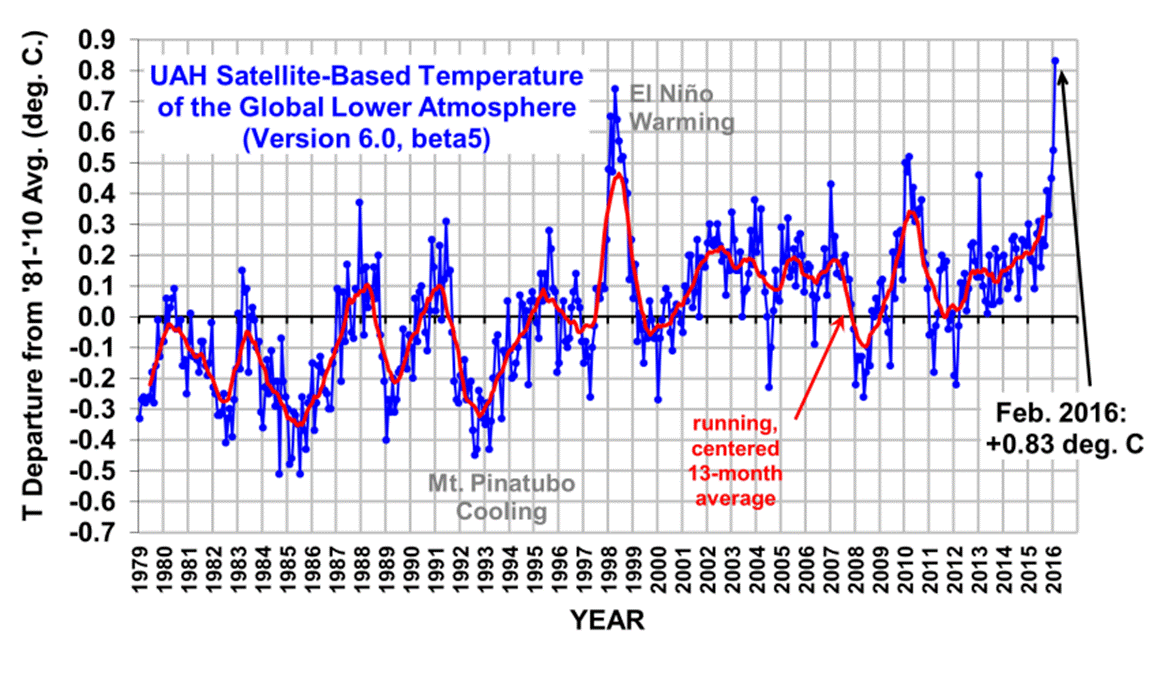
Lower atmosphere also sets a record in February
Satellite-based estimates of temperature in the lowest few miles of the atmosphere also set an impressive global record in February. Calculations from the University of Alabama in Huntsville show that February’s reading in the lower atmosphere marked the largest monthly anomaly since the UAH dataset began in late 1978. UAH's Dr. Roy Spencer, who considers himself a climate change skeptic, told Capital Weather Gang earlier this month, “There has been warming. The question is how much warming there’s been and how does that compare to what’s expected and what’s predicted.” The satellite readings apply to temperatures miles above Earth’s surface, rather than what is experienced at the ground, and a variety of adjustments and bias corrections in recent years (including an important one just this month) have brought satellite-based readings closer to the surface-observed trends.
Figure 2. Anomalies (departures from average) in surface temperature across the globe for February 2016, in degrees Centigrade, as analyzed by NASA’s Goddard Institute for Space Studies. Image credit: NASA/GISS.
Arctic leads the way
Figure 2 shows a big factor in the February result: a superheated Arctic. As shown by the darkest-red splotches in the figure, large parts of Alaska, Canada, eastern Europe, and Russia, as well as much of the Arctic Ocean, ran more than 4.0 °C (7.2 °F) above average for the month. This unusual warmth helped drive Arctic sea ice to its lowest February extent on record in February 2016. The tremendous Arctic warmth was probably related to interactions among warm air streaming into the Arctic, warm water extending poleward from the far northeast Atlantic, and the record-low extent of Arctic sea ice. Ground Zero for this pattern was the Barents and Kara Seas, north of Scandinavia and western Russia, where sea ice extent was far below average in February. Typically, the Norwegian archipelago of Svalbard -- which includes the northernmost civilian settlements on Earth -- is largely surrounded by ice from early winter into spring. This winter, the edge of the persistent ice has stayed mostly to the north of Svalbard, which has helped an absurd level of mildness to persist over the islands for months. Air temperatures at the Longyearbyen airport (latitude 78° N) have been close to 10 °C (18 °F) above average over the past three-plus months. This is the single most astounding season-long anomaly we’ve seen for any station anywhere on Earth. (If anyone can beat it, please let us know and we’ll add it here!)
Figure 3. Daily temperatures (in Celsius, °C) for the past year at the Longyearbyen Airport, Svalbard, Norway, located at latitude 78° N. The black line shows the seasonal average; blue and red traces show the day-to-day readings. The darker blue and red line shows the 30-day running average, which was 10.2 °C (18.4 °F) above normal in February. Thus far in March, the anomaly (not shown here) has been even larger, close to 12 °C (22 °F). Image credit: Norwegian Meteorological Institute.
February's heat had severe impacts
It has long been agreed upon in international climate negotiations that a 2v°C warming of the Earth above modern pre-industrial levels represents a "dangerous" level of warming that the nations of the world should work diligently to avoid. The December 2015 Paris Climate Accord, signed by 195 nations, included language on this, and the Accord recommend that we should keep our planet from warming more than 1.5 °C, if possible. Although the science of attributing extreme weather events to a warming climate is still evolving (more on this in an upcoming post), February 2016 gave us a number of extreme weather events that were made more probable by a warmer climate, giving us an excellent example of how a 2 °C warming of the climate can potentially lead to dangerous impacts. And, as we have been repeatedly warned might likely be the case, these impacts came primarily in less developed nations -- the ones with the least resources available to deal with dangerous climate change. According to the February 2016 Catastrophe Report from insurance broker Aon Benfield, three nations suffered extreme weather disasters in February 2016 that cost at least 4% of their GDP -- roughly the equivalent of what in the U.S. would be five simultaneous Hurricane Katrinas. According to EM-DAT, the International Disaster Database, these disasters set records for the all-time most expensive weather-related disaster in their nations' history. For comparison, nine nations had their most expensive weather-related natural disasters in history in all of 2015, and only one did so in 2014. Here are the nations that have set records in February 2016 for their most expensive weather-related natural disaster in history:
Vietnam has suffered $6.7 billion in damage from its 2016 drought, which has hit farmers especially hard in the crucial southern Mekong Delta. This cost is approximately 4% of Vietnam's GDP, and beats the $785 million cost (2009 USD) of Typhoon Ketsana of September 28, 2009, for most expensive disaster in their history. In this image, we see a boy holding his brother walking across a drought-hit rice field in Long Phu district, southern delta province of Soc Trang on March 2, 2016. Image credit: STR/AFP/Getty Images.
Zimbabwe has suffered $1.6 billion in damage from its 2016 drought. This is approximately 12% of their GDP, and beats the $200 million cost (2003 USD) of a February 2003 flood for most expensive disaster in their history. Zimbabwe's President Robert Mugabe on February 5, 2016, declared a 'state of disaster' in many rural areas hit by a severe drought, with more than a quarter of the population facing food shortages. This photo taken on February 7, 2016, shows the fast-drying catchment area of the Umzingwani dam in Matabeleland, Southwestern Zimbabwe. Image credit: Ziniyange Auntony/AFP/Getty Images.
Fiji suffered $470 million in damage from Category 5 Cyclone Winston's impact in February. This is approximately 10% of their GDP. The previous costliest disaster in Fiji was Tropical Cyclone Kina in January 1993, at $182 million (2016 USD) in damage. In this image, we see how Category 5 winds can completely flatten human-built structures: Fiji's Koro Island received a direct hit from Winston when the storm was at peak strength with 185 mph winds. Image credit: My Fijian Images and Jah Ray.
One other severe impact from February's record heat is the on-going global coral bleaching episode, just the third such event in recorded history (1998 and 2010 were the others). NOAA's Coral Reef Watch has placed portions of Australia's Great Barrier Reef under their "Alert Level 1," meaning that widespread coral bleaching capable of causing coral death is likely to occur. Widespread but minor bleaching has already been reported on the reef, and the coming month will be critical for determining whether or not the reef will experience its third major mass bleaching event on record.
Figure 4. Annual mean carbon dioxide growth rates for Mauna Loa, Hawaii. In the graph, decadal averages of the growth rate are also plotted, as horizontal lines for 1960 through 1969, 1970 through 1979, and so on. The highest one-year growth in CO2 was in 2015, at 3.05 ppm. The El Niño year of 1998 was a close second. The estimated uncertainty in the Mauna Loa annual mean growth rate is 0.11 ppm/yr. Image credit: NOAA’s Greenhouse Gas Reference Network.
Last year saw Earth’s highest-ever increase in carbon dioxide
Despite efforts to slow down human emissions of carbon dioxide, 2015 saw the biggest yearly jump in global CO2 levels ever measured, said NOAA last week. The annual growth rate of atmospheric carbon dioxide measured at NOAA’s Mauna Loa Observatory in Hawaii jumped by 3.05 parts per million during 2015, the largest year-to-year increase since measurements began there in 1958. In another first, 2015 was the fourth consecutive year that CO2 grew more than 2 ppm, said Pieter Tans, lead scientist of NOAA's Global Greenhouse Gas Reference Network. “Carbon dioxide levels are increasing faster than they have in hundreds of thousands of years,” Tans said. “It’s explosive compared to natural processes.” The last time the Earth experienced such a sustained CO2 increase was between 17,000 and 11,000 years ago, when CO2 levels increased by 80 ppm. Today’s rate of increase is 200 times faster, said Tans. In February 2016, the average global atmospheric CO2 level stood at 402.59 ppm. Prior to 1800, atmospheric CO2 averaged about 280 ppm.
The big jump in CO2 in 2015 is partially due to the current El Niño weather pattern, as forests, plant life and other terrestrial systems responded to changes in weather, precipitation and drought. In particular, El Niño-driven drought and massive wildfires in Indonesia were a huge source of CO2 to the atmosphere in 2015. The largest previous global increase in CO2 levels occurred in 1998, which was also a strong El Niño year. However, continued high emissions from human-caused burning of fossil fuels are driving the underlying growth rate. We are now approaching the annual peak in global CO2 levels that occurs during northern spring, after which the value will dip by several ppm. It is quite possible that the annual minimum in late 2015 will for the first time fail to get below 400 ppm, as predicted by Ralph Keeling (Scripps Institution of Oceanography) last October. To track CO2 concentrations at Mauna Loa and global CO2 concentrations, visit NOAA’s Greenhouse Gas Reference Network and the Keeling Curve website (Scripps).
For more on Saturday’s bombshell report, check out the coverage from Andrew Freedman (Mashable), Eric Holthaus (Slate), and Tom Yulsman (Scientific American/ImaGeo). We’ll have a follow-up post later this week on NOAA’s global climate report for February and for the Dec-Feb period, along with a roundup of all-time records set in February at major stations around the world.
https://www.wunderground.com/blog/JeffMasters/comment.html?entrynum=3264


No comments:
Post a Comment