NSIDC: A slow start to the spring melt season
Sign up for the 
May 4, 2009 -- Arctic sea ice extent declined quite slowly in April; as a result, total ice extent is now close to the mean extent for the reference period (1979 to 2000). The thin spring ice cover nevertheless remains vulnerable to summer melt.
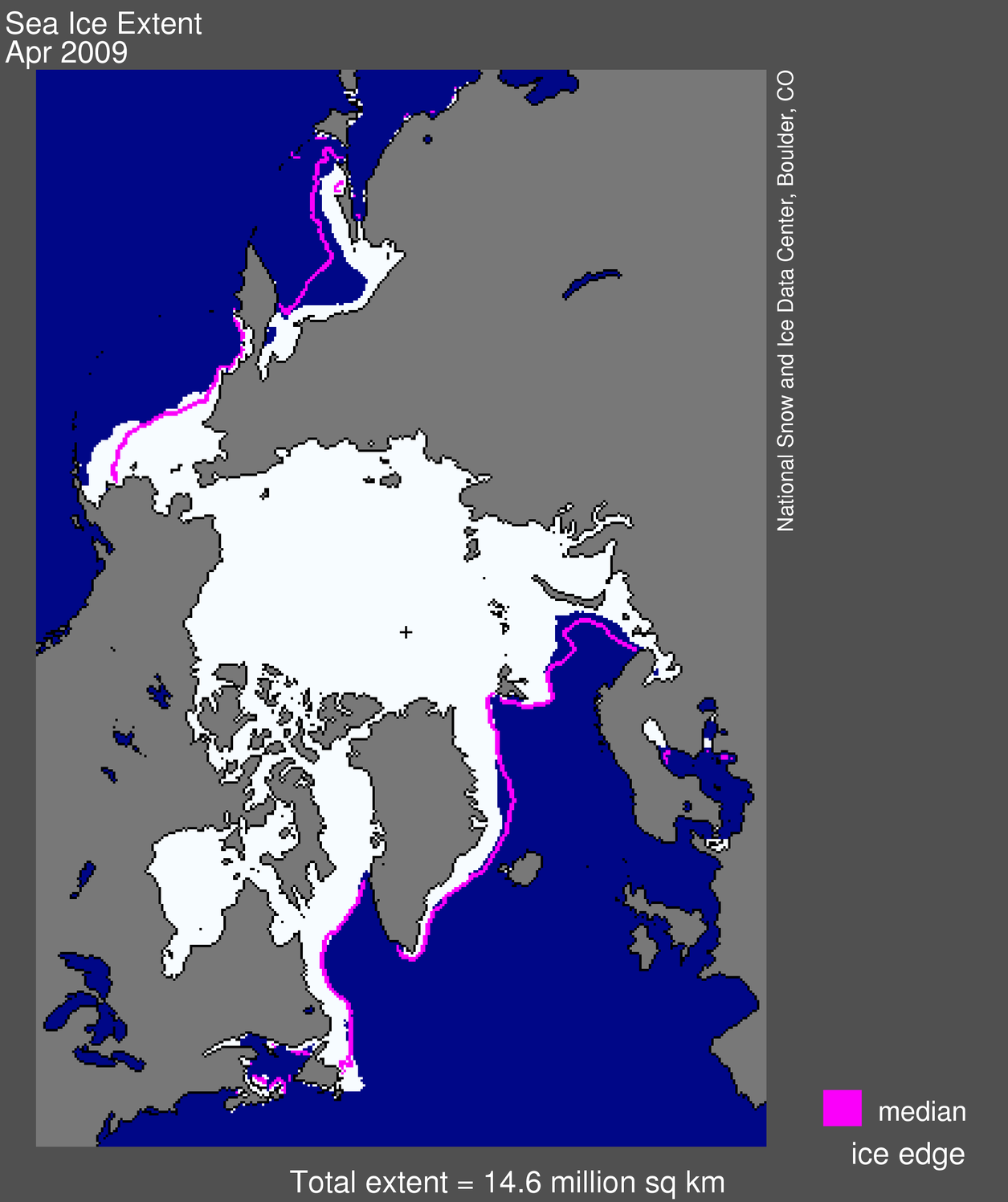 Figure 1. Arctic sea ice extent for April, 2009, was 14.58 million square kilometers (5.63 million square miles). The magenta line shows the 1979 to 2000 median extent for that month. The black cross indicates the geographic North Pole. Sea Ice Index data. About the data. —Credit: National Snow and Ice Data Center. High-resolution image
Overview of conditions
Sea ice extent averaged over the month of April 2009 was 14.58 million square kilometers (5.63 million square miles). This was 710,000 square kilometers (274,000 square miles) above the record low for April in 2007, and 420,000 square kilometers (162,000 square miles) below the 1979 to 2000 average.
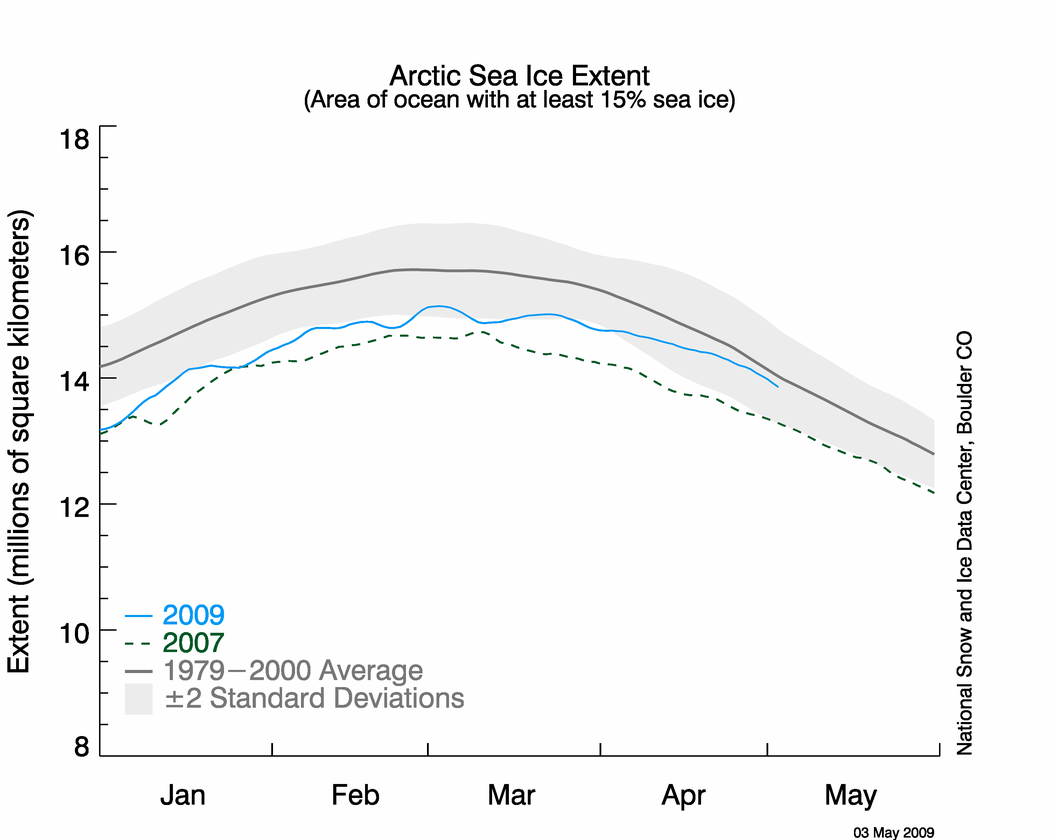 Figure 2. The graph above shows daily sea ice extent as of May 3, 2009. The solid blue line indicates 2009; the dashed green line shows 2007;and the solid gray line indicates average extent from 1979 to 2000. The gray area around 1979-2000 average line shows the two standard deviation range of the data. Sea Ice Index data. —Credit: National Snow and Ice Data Center. High-resolution image
 Conditions in context
The decline rate for the month of April was the third slowest on record. The Arctic lost sea ice cover at a rate of 27,300 square kilometers per day (10,500 square miles), compared to an average of 41,600 square kilometers (16,000 square miles) per day for 1979 to 2000. Ice extent was well above normal in the Bering Sea, but below normal in the Barents Sea and the Sea of Okhotsk.
For the past few years, Arctic sea ice extent for most months has been more than two standard deviations below the 1979 to 2000 mean, particularly in summer. Two standard deviations provide an estimate of the expected range of natural variability. Because of cooler than average temperatures, Arctic sea ice extent at the end of April 2009 was within the expected range of natural variability.
 Figure 3. Monthly April ice extent for 1979 to 2009 shows a decline of 2.8% per decade. —Credit: National Snow and Ice Data Center courtesy NOAA/ESRL Physical Sciences Laboratory. High-resolution image
April 2009 compared to past Aprils
Compared to previous Aprils, April 2009 is near the middle of the distribution (10th lowest of 31 years). The linear trend indicates that for the month of April, ice extent is declining by 2.8% per decade, an average of 42,400 square kilometers (16,400 square miles) of ice per year.
 Figure 4. The map of air temperature anomalies for April 1 to 15, 2009, at the 925 millibar level (roughly 1,000 meters [3,000 feet] above the surface), shows cooler-than-usual conditions over much of the Arctic Ocean. Areas in blue correspond to negative (cool) anomalies. Areas in orange and red correspond to strong positive (warm) anomalies. —Credit: National Snow and Ice Data Center courtesy NOAA/ESRL Physical Sciences Laboratory. High-resolution image
Causes of the slow April decline
Cool conditions over the Bering Sea, noted in the April 2009 update, persisted through mid-April. Cool weather also slowed ice loss in the Barents Sea. The cool temperatures resulted from the movement of cold air from eastern Siberia across the central Arctic. After mid-April, the pattern shifted to relatively warmer conditions in the Bering Sea and melt progressed, resulting in the faster decline in the total extent during the second half of the month.
It is difficult to assess how the slow decline through April will affect the summer minimum ice extent. Persistence of cool conditions through the summer could lead to a greater September ice extent compared to that of recent years. However, as discussed in our last post, the spring ice cover is thin and hence quite vulnerable to summer melt. However this summer unfolds, scientists expect to see high year-to-year variability in ice extent embedded within the long-term decline.
 Figure 5. This map shows regions of above- and below-average precipitation observed in winter, following summers with very low Arctic sea ice extent. —Credit: From the National Snow and Ice Data Center, courtesy J. Francis, Rutgers University. High-resolution image
Can summer ice extent affect winter weather?
A new study suggests that Arctic ice extent at the end of summer can affect precipitation at lower latitudes the following winter. Jennifer Francis from Rutgers University and colleagues compared winter weather following summers with below-average ice extent, to weather following summers with above-average ice. The researchers found that low summer sea ice extent is linked to drier winters over much of the U.S., Scandinavia, and Alaska, and wetter winters in the northern Mediterranean, Japan, and the Pacific Northwest.
The study showed that extensive ice loss in summer warmed the Arctic atmosphere during autumn. This warmth weakened the storm track that encircles the northern hemisphere, affecting weather patterns far away from the Arctic. As sea ice continues to decline in summer, these influences will become more prominent.
Reference
Francis, J. A., W. Chan, D. J. Leathers, J. R. Miller, & D. E. Veron. 2009. Winter Northern Hemisphere weather patterns remember summer Arctic sea-ice extent. Geophysical Research Letters, 36, L07503; doi:10.1029/2009GL037274.
NSIDC scientists provide Arctic Sea Ice News & Analysis, with partial support from NASA.
Link to this article at the NSIDC: http://nsidc.org/arcticseaicenews/index.html


No comments:
Post a Comment