Thursday, July 21, 2016

Jeff Masters: Eastern Hemisphere's All-Time Temperature Record: Kuwait Fries in 54 °C (129.2 °F) Heat

by Jeff Masters, wunderblog, July 22, 2016

   
It was a historic day in the annals of meteorology on Thursday, July 21, 2016, in the Middle East, where the temperature in Mitribah, Kuwait, soared to an astonishing 54 °C (129.2 °F). If verified, this would be Earth's hottest temperature ever reliably measured outside of Death Valley, California, according to wunderground's weather historian Christopher C. Burt and world weather extremes expert Maximiliano Herrera. The temperature is likely to be verified, since Thursday's incredible heat also extended into Iraq, which set their all-time heat record: 128 °F (53.4 °C) at Basrah. According to Burt and Herrera, Thursday's Basrah reading ranks as the fourth highest temperature ever reliably measured outside of Death Valley; the only higher non-Death Valley temperatures were today's 54 °C (129.2 °F) at Mitribah, Kuwait, a 53.6 °C reading at Sulaibya, Kuwait, in 2011, and a 53.5 °C reading at Mohenjodaro, Pakistan, on May 26, 2010. Note that there is one other competitor for hottest non-Death Valley temperature ever measured: the official all-time high temperature in Israel is a 54 °C (129.2 °F) reading from Tirat Tsvi, Israel, on June 22, 1942. The Israeli Met Office pursued an investigation of the record in 2012, prompted by an inquiry from the World Meteorological Organization (WMO) and convincing evidence from wunderground's weather historian Christopher C. Burt and weather extremes expert Howard Rainford that the actual high temperature was a full degree lower. The Israeli Met Office concluded that the record was valid, but refused to make public the details leading to their conclusions. Until they do so, the record remains suspect.


Figure 1. A photograph of the official Furnace Creek, Death Valley, maximum recording thermometer at time of observation on Monday morning July 1, 2013 (which was for the maximum temperature measured on June 30). The photo shows a maximum of 129.2 °F was reached, tying it with the 129.2 °F reading at Mitribah, Kuwait, on July 21, 2016, for the highest reliably measured temperature on Earth, according to wunderground's weather historian Christopher C. Burt and world weather extremes expert Maximiliano Herrera. Observations at the site are made only at 4 p.m. and 7 a.m. daily. The shelter door is not opened at any other time in order to not affect the ambient air temperature inside the shelter. You may have seen a different image of this same thermometer on the NWS-Las Vegas web site posted July 1, 2013, that shows the temperature just shy of 129 °F. That is because THAT photograph was taken after the thermometer had been removed from its shelter and turned vertically, which caused the mercury to slip down the tube about 0.3 °F. This photograph was taken prior to the thermometer being removed from the shelter. Photo courtesy of Death Valley National Park and NWS-Las Vegas.

Comparison with Death Valley temperatures
The official world record high temperature is 56.7 °C (134.1 °F) on July 10, 1913, in Furnace Creek Ranch, California, in Death Valley. Mr. Burt has commented "the record has been scrutinized perhaps more than any other in the United States. I don't have much more to add to the debate aside from my belief it is most likely not a valid reading when one looks at all the evidence." He proposes that the highest reliably recorded temperature at Death Valley is a 54.0 °C (129.2 °F) reading on June 30, 2013 -- tied with Thursday's measurement in Kuwait. The 129.2 °F value at Death Valley was rounded down to 129 °F in the official record, though. Death Valley has also recorded 53.9 °C (129 °F) four times: July 20, 1960; July 18, 1998; July 20, 2005; and July 7, 2007. There is no evidence that the temperature reached 129.2 °F on those dates, unlike the reading on June 30, 2013.

The Middle East's heat wave continues on Friday
The Middle East's astonishing heat wave will last one more day. Friday's high in Basrah, Iraq, is predicted to hit 128 °F and Mitribah, Kuwait, is predicted to hit 127 °F. Gotvand, Iran, is predicted to hit 126 °F -- very close to Iran's all-time heat record of 127.4 °F, set most recently at Gotvand on July 17, 2014. On Saturday, the ridge of high pressure bringing the record heat will weaken, bringing temperatures about 10 °F cooler to Iraq and Kuwait and about 2-4 °F cooler to Iran.

Mr. Burt plans to post an in-depth look at the new heat records in a forthcoming post.

I'll have an update on the tropics on Friday afternoon.
Friday, July 1, 2016

M. A. Cooper et al., GRL (2016), Paleofluvial landscape inheritance for Jakobshavn Isbræ catchment, Greenland

Please go to the link to the full, open-access article for the amazing figures showing the ancient river beds under the ice sheet:

http://onlinelibrary.wiley.com/doi/10.1002/2016GL069458/full

Geophysical Research Letters,  (21 June 2016); doi10.1002/2016GL069458

Paleofluvial landscape inheritance for Jakobshavn Isbræ catchment, Greenland

M. A. Cooper*, K. Michaelides, M. J. Siegert and J. L. Bamber

Abstract

Subglacial topography exerts strong controls on glacier dynamics, influencing the orientation and velocity of ice flow, as well as modulating the distribution of basal waters and sediment. Bed geometry can also provide a long-term record of geomorphic processes, allowing insight into landscape evolution, the origin of which may predate ice sheet inception. Here we present evidence from ice-penetrating radar data for a large dendritic drainage network, radiating inland from Jakobshavn Isbræ, Greenland's largest outlet glacier. The size of the drainage basin is ∼450,000 km2 and accounts for about 20% of the total land area of Greenland. Topographic and basin morphometric analyses of an isostatically uplifted (ice-free) bedrock topography suggests that this catchment predates ice sheet initiation and has likely been instrumental in controlling the location and form of the Jakobshavn ice stream, and ice flow from the deep interior to the margin, now and over several glacial cycles.


A 3.5-million-year-old river network preserved beneath the Greenland Ice Sheet

An ancient drainage basin covering one fifth of Greenland predates the ice sheet and strongly influences the modern Jakobshavn Glacier, according to a new analysis of ice-penetrating radar data.

SOURCE: Geophysical Research Letters
by Terri Cook, EOS.org,
Using detailed geophysical surveys of Greenland and Antarctica conducted during the past few decades, scientists can now peer below the thick glacial ice to learn more about the origin and evolution of the underlying landscape. To date, most of these studies of subglacial topography have focused on Antarctica. Now Cooper et al. have turned their attention to Greenland, where they have discovered the first evidence of an extensive network of rivers in the landscape beneath the Jakobshavn Isbræ, the island’s largest outlet glacier.
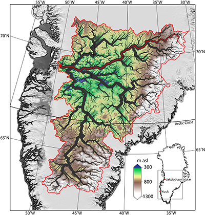
Using a digital elevation model generated from ice-penetrating radar data and corrected for the weight of the modern ice sheet, the team charted the ancient river network using two different software packages. The results of both tools reveal a dendritic network of valleys radiating inland from the Jakobshavn Glacier —a landscape that, according to the researchers, covers an area comparable in size to the Ohio River Basin and predates the formation of the ice sheet about 3.5 million years ago.
Ancient river network beneath Jakobshavn Glacier.
The ancient river network underneath Jakobshavn Isbræ basin is shown in black; a main stream of the catchment is marked by the solid red line. Bed elevation (between 300 and 1,300 meters above sea level) is also shown. Credit: Cooper et al., 2016.
The team’s analysis reveals a watershed that is mostly smooth and low in elevation but also includes mountainous terrain on its eastern edge, for a total elevation range of 3,382 meters. Within this basin, the team discovered very large channels up to 1,400 meters deep and 12 kilometers wide—dimensions that exceed the recently reported north Greenland “megacanyon.” Their findings of low valley width-to-depth ratios, V-shaped channel cross sections, and a main channel elevation profile typical of river networks all support the conclusion that extended river incision, rather than glacial erosion, was the dominant process that formed this network.
Assuming a steady rate of incision into the hard, underlying gneiss, the researchers estimate that it would have taken about 2.3 million years to carve the observed channels, although they acknowledge that processes like glacial outbursts or increased discharge during interglacial periods could have shaped them over much shorter periods of time.
Near the basin outlet, the researchers also observed an abrupt break in slope at the confluence of three ancient channels. This knickpoint coincides with the location where the surface flow of the Jakobshavn Glacier rapidly accelerates, a finding that suggests that the underlying, preglacial landscape exerts a strong influence on the location, shape, and size of Greenland’s largest outlet glacier. 
(Geophysical Research Lettersdoi:10.1002/2016GL069458, 2016)
—Terri Cook, Freelance Writer
Citation: Cook, T. (2016). A river network preserved beneath the Greenland ice sheet, Eos, 97, doi: 10.1029/2016EO054839. Published on 28 June 2016.