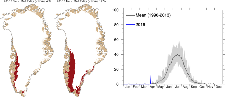
12 Percent. That’s how much of Greenland’s surface experienced melt yesterday according to a report from DMI’s Polar Portal as an unprecedented flow of warm, wet air slammed into its great ice sheets. 10 Percent. That’s how much of Greenland’s ice sheet surface is required to melt in order to mark an official start to the Summer melt season. Late May or early June. That’s when Greenland melt season typically begins.
In other words, a Greenland melt season that usually starts as May rolls into June, and has never initiated before May 5th, just began on April 11th of 2016. That’s 24 days ahead of the previous record, set only 6 years ago, and more than a month and a half ahead of the typical melt start. In other words — way too early. But in a rapidly heating world where monthly temperatures have now exceeded a range of 1.5 C above 1880s' levels, we could well expect Greenland melts to begin earlier, end later, and encompass more and more of the ice sheet surface at peak melt during July.
Record early start to Greenland’s ‘Summer’ melt season occurred on April 11, 2016, according to reports from DMI’s Polar Portal.
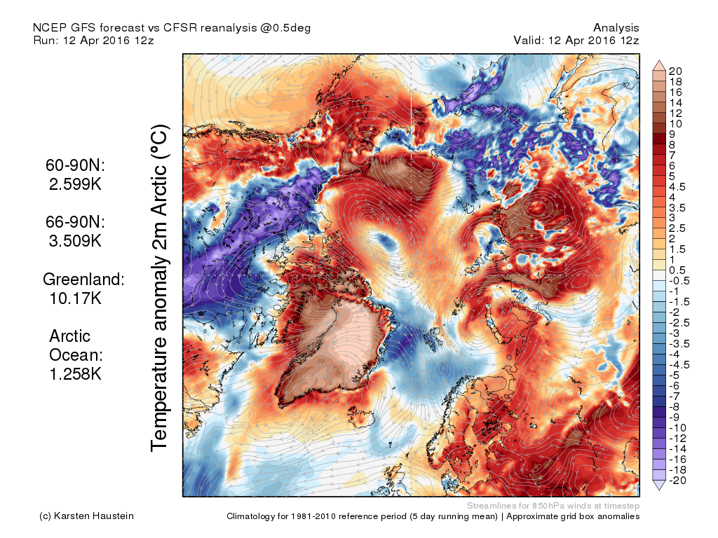
Yesterday’s new record early melt start occurred as extraordinarily warm temperatures in the range of 20-40 degrees Fahrenheit above average swept over southern, central and western Greenland. This flood of extremely warm temperatures for Greenland was accompanied by heavy rains and strong winds — gusting to gale or even hurricane force in some locations. In some areas, rain fell over the ice sheet itself. As recently as midday Tuesday, Dr. Jason Box — a prominent Greenland researcher — tweeted a report from a friend in Nuuk that the city was “close to drowning in water caused by rain and snow melt.”
Today, temperatures for the whole of Greenland — a 1.7-million square kilometer island containing enough ice to raise sea levels by more than 20 feet should it all melt — were measuring as high as 10.17 C above average (more than 18 F above average), with readings over much of northern and central Greenland spiking over 20 C (36 F) above normal (1980-2010) ranges. So it’s likely that Monday’s record early 12% surface melt will extend and possibly expand on through today (April 12).
Extreme warmth over much of Greenland on April 12th is continuing a new record early start to melt season for this up to two-mile-high pile of ice. Image source: Karsten’s Climate Maps. Data Source: NOAA/NCEP/GFS.
Over the coming week, temperatures across Greenland are expected to steadily fall back toward more normal ranges. However, it’s worth noting that much of the heat from this year’s record early melt spike will be baked into the ice — adding a kind of internal heat pressure as Spring gradually progresses into Summer.
During July of 2012, an unprecedented 95% of Greenland’s surface experienced melt. For 2016, unprecedented Arctic warming during Winter appears to have set the stage for a serious challenge to both 2012 Greenland and 2012 Arctic sea ice melt records. And with seasonal sea ice at or near new record lows even as Greenland is off to an amazingly early melt start, it appears that 2016 is now in a race to set a number of new benchmarks as Arctic ice continues its ominous and disruptive longer-term decline.


No comments:
Post a Comment